| Home | Welcome | What's New | Site Map | Glossary | Weather Doctor Amazon Store | Book Store | Accolades | Email Us |
 | |||||||||
The Temperature Inversion
Of course, the atmosphere does not always have a uniform lapse rate or inversion condition, there may be regions with a vertical cross section of the atmosphere where the temperature structure changes its rate and may shift from lapse to inversion and vice versa once or several times. Several common situations can produce an inversion layer in the lower atmosphere. A few, like nocturnal cooling and the movement of warm air over colder surfaces, are found at ground level or just above it. Others, such as frontal inversions, may touch the ground or may have their base at some height above ground. Inversions may also occur in the upper levels of the troposphere, the most noteworthy being the subsidence inversion found in anticyclones due to compressional heating. Layering of the Troposphere
An important point to mention here is that the temperature of the air and the density of the air are related, and this has important implications as to what happens to a parcel of air that is raised or lowered to a different altitude by some means. When a parcel is raised, it cools at a standard rate through expansion; when it descends, it warms at this rate through compression. Meteorologists call this change in temperature when the parcel’s elevation is changed a dry adiabatic process. The term adiabatic refers to the change of temperature of an air parcel without gain or loss of heat from it through outside factors, and dry indicates that neither condensation nor evaporation occurs within it. (There is a wet adiabatic process, which accounts for the releases of latent heat through changes in the state of water vapour.) The change in temperature of a parcel when raised or lowered through a dry adiabatic process is 9.8 C deg / 1000m (5.5 F deg / 1000 ft). In the simplest situation, if a parcel is raised or lowered in an adiabatic process, it will cool or warm to a temperature dependent on the altitude change. If the moved parcel becomes warmer than the surrounding air at its new level, its lower density will cause it to move upward adiabatically to a new level where the densities of parcel and environment are equal. Similarly, if the moved parcel is cooler than the new elevation, it will sink to seek density equilibrium. When a parcel of air continues to ascend until adiabatic cooling brings its density down to that of the surrounding air, the condition is considered unstable since the parcel continues to ascend freely once pushed from its initial height. Unstable conditions are common near the planetary surface during daytime solar heating. Conversely, a parcel pushed to a height where it is colder than its environment seeks to return to its initial elevation and the situation is termed stable. A third condition also exists. In this case, the parcel moved from its original position adiabatically to a position where its density matches that of the surrounding air. Since it is in density equilibrium, it will remain at that elevation, a condition termed neutrally stable. Radiation Inversions
Once a shallow inversion layer forms, it will continue to grow as long as the surface is cooling unless the wind speed is great enough to mechanically mix the surface air with the warmer air above it. In calm or nearly calm conditions, the heavier air within the inversion will not mix with the less dense air above it, and the inversion can grow. Surface radiation inversions have important consequences for local air quality. Radiation fog often forms in a surface inversion layer when the temperature within drops below the condensation temperature (dew point). Frontal InversionsWhen a weather front moves across an area, regions of elevated inversions form whose height depends on the nature of the air masses. In a warm front, the warm air overriding cooler air ahead of it establishes both the front and the inversion. The height of the inversion base is lowest at the frontal wedge common point and highest the furthest out that the warmer air has penetrated. In a cold front, the inversion is initially surface based as the advancing cold air wedges under the warm air. 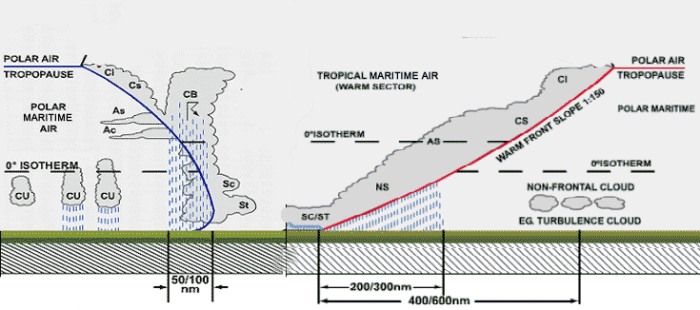 Frontal inversions may also form along mesoscale fronts such as the sea-breeze or lake-breeze fronts over land and the land-breeze front over the water. Surface-Cooling InversionsRadiation inversions form when the planetary surface cools due to radiational heat loss that is conducted into the surface air layer. If the planetary surface is significantly colder than the air moving over it, an inversion will form, and may be quite strong and deep when the overriding wind is light. Most common surface-cooling inversions form when warm air moves across ice- or snow-covered surfaces or bodies of cold water. In many situations, surface fogs arise when warm, moist air travels over a cold surface and its temperature drops below the condensation level. 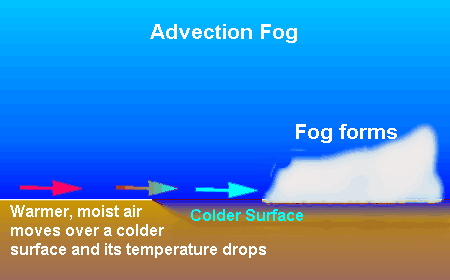 Subsidence Inversions
Topographically Induced Inversions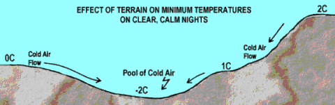 The topography of a region can also produce local inversions, particularly in mountainous terrain. In such situations, cold air descends from elevation due to its higher density and undercuts the warmer air at lower elevations, forming the inversion. These cold air currents usually follow the same drainage patterns that water would flow down the terrain and can pool in depressions, stream beds and over lakes. The production of a cold air stream need not require very high terrain, and can form in hilly regions or along river valley edges. 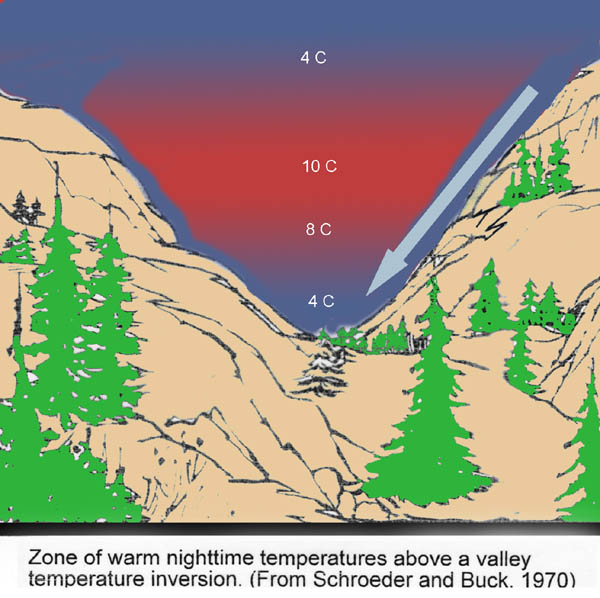 Other InversionsThe above are the most common inversion types and formation mechanisms, but not all. The ozone layer in the stratosphere forms a chemically produced inversion by the heat released in the photochemical processes of the ozone formation/destruction cycle. Evaporation of liquid water that takes heat from an air parcel may also form an inversion layer as can the advection of colder air into a warmer air mass at higher elevations. Learn More From These Relevant Books
|
|||||||||
 |
Now AvailableThe Field Guide to Natural Phenomena: |
Now Available! Order Today! | |
 |
 |
Now |
The BC Weather Book: |


 The atmosphere’s temperature structure in the vertical — the change of temperature with height above the surface — plays a key role in many important weather phenomena that range in scale from the global to the micro scales. Many definitions of the
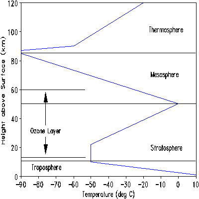
 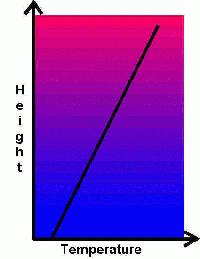 There are, however, several common situations where the reverse occurs; that is, when cooler air lies beneath a warmer air layer. This condition is called an inversion, and if the coldest air is against the earth’s surface, a surface inversion. Inversions also occur higher in the atmosphere within and above the troposphere, and in fact, the general thermal structure of stratosphere is an inversion layer. As the diagram here shows, the stratosphere is warmer in the ozone layer than the higher altitudes of the troposphere, and this constitutes an inversion. A second “sphere” of warmer air can be found in the extreme upper layer, the thermosphere, where the tenuous atmosphere is buffeted by the solar wind. (The upper atmosphere thermal structure is not the focus of this article, however, and we will be looking closer to the planetary surface herein.)
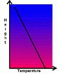 To give a basis for what is an inversion, we must look at what meteorologists consider the natural state of the troposphere. If we ignore the lowest portion of the atmosphere, say the lower 100 m (328 ft), the air temperature, in an ideal state, will decrease with height, and this decrease is 6.4 C deg per 100 m (3.5 F deg per 1000 ft). This ideal state frequently differs from the actual change of temperature with height, and the environmental lapse rate — the actual change of temperature with height — is an important measure for many atmospheric phenomena including the severity of convective storms.
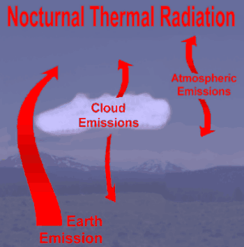 The most common mechanism that forms an inversion condition is the loss of surface heat through long-wave (heat) radiation when the solar input into the
 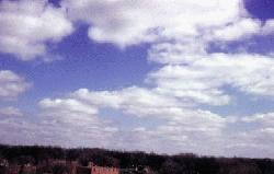 The subsidence inversion is found at higher altitudes, usually in the core of anticyclones where slowly descending air heats by compression as it sinks. This subsidence will produce an elevated inversion within the air mass at some height above the ground. The subsidence inversion has important consequences for air quality as it limits the volume of air in which pollutant emissions are mixed. However, the most common impact of subsidence inversions is on the depth of cumulus clouds forming beneath it. The inversion caps the depth of the fair-weather cumulus (