The dawn brought one of those "lambish" March mornings. The clear sky
turned robin's egg blue as the dawn twilight arch gave way to morning,
and all through the event the winds blew lightly — if at all. In a few
hours, the warm sun would break the morning chill, and by mid-morning
the perfectly clear sky would begin to lose its fair complexion as
small buds of whiteness pop up hither and yon. So started a day when cumulus humilis,
the most basic of the cumulus cloud family, would fill the skyscape.
This cloud type often is the forerunner to larger, more developed
cumulus varieties that fill the afternoon sky. But today, these fair-weather cumuli dot the sky within the large high-pressure cell that sat over the region.
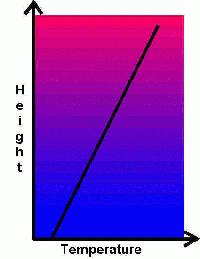
An Inversion Temperature Profile
Early spring is often a good time for cumulus humilis formation because
the warming sun still has limited strength to heat the ground surface,
particularly if snow and ice cover the soil. High pressure systems in
early spring often retain some of their winter weight, and the excess
pressure sinks the colder air toward the surface, warming it by
compression to form a rather strong temperature inversion. In the
inversion, a warm air layer at altitude caps a cold air layer that
during the night reached the surface. Now with heating from the
mid-morning sun, a shallow layer of warm air begins to form at the cold
air's base.
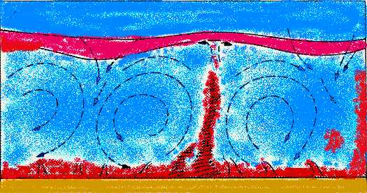
Forming Thermals
Once a spot on
the ground surface has been heated to a greater temperature than the
air immediately above it, a buoyant bubble or air, or thermal,
will usually form. Thermals take shape most readily over dark soil,
rock or pavement and less easily over snow- and ice-covered surfaces.
The thermal, being lighter than its surroundings, ascends into the
colder air. As the thermal or updraft ascends, the bubble of
air expands and thus cools. As the ascent and expansion continue, the
thermal's core temperature drops. When its temperature approximately
equals that of the surrounding air, the ascent stops.
Thermal Plumes send Surface Air To Higher Altitudes
Across the local landscape, many such thermal plumes may be rising
at any given time. You can see something similar to this by watching a
pot of water begin to boil on the stove. Around the pot, you will see
trails of rising bubbles as the water heats toward rapid boiling. (For
more on buoyancy updrafts, see my article "What Goes Up".)
When the wind field around the thermal is light (like the condition in
the pot), the thermal rises almost vertically. If the wind is moderate,
the thermal rises at an angle tilted in the downwind direction. But if
the wind if very strong and gusty, the thermals may be broken apart,
quickly mixed with the surrounding air and thus have only a limited
ascent.
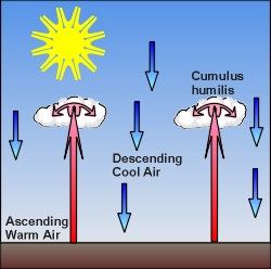
Forming Clouds
Once the thermals
rise above the surface, the potential for cloud development increases.
Whether a cloud will arise from any particular thermal depends on the
moisture content of that thermal when it forms, the height to which it
rises, and the temperature and moisture content (or humidity) of the air through which it moves. At some altitude in the surrounding atmosphere, a thermal will reach its condensation level.
At the condensation level, the relative humidity of the thermal air
will be around 100 percent (saturated), and liquid droplets may arise
from condensation of the thermal's water vapour.
If the
thermal is unable to reach its condensation level, no clouds form and
skies remain clear. But if the thermal punches through this altitude,
clouds begin to take shape. Since the surrounding air within the high
pressure cell is rather uniform in its temperature and moisture
properties, the condensation level (also called the lifting condensation level and the cloud base)
occurs at a rather consistent altitude over the region (usually around
3200 to 5000 metres or 2000 to 3000 feet). Therefore, the bases of
young cumulus clouds can all be found at a similar altitude.
Above
the cloud base, small visible clouds begin to appear as heaps atop the
rising air column and, for this reason, are collectively called cumulus
clouds. With conducive conditions for further growth, the initial
cumulus can develop into larger and taller formations such as cumulus congestus, cumulus castellanus and the ultimate giant, cumulonimbus. But today, the sinking airmass and overlying elevated inversion prevent the cumuli from reaching great heights, and we have cumulus humilis. Humilis means humble in Latin, and accurately describes these smallest members of family Cumulus.
Typically,
cumuli humilis have cloud tops at 5000-8000 m (3000-5000 ft), making
them shallow and very distinct in their outlines. As their family name
denotes, they are small heaps of clouds with flat bottoms and rounded
tops, and often look like they have been formed by a biscuit cutter out
of cotton balls. Although it may appear that these clouds live a long
life over the afternoon, each individual cloud actually lasts but five
to forty minutes before slowly fading away as its air is mixed into the
surroundings. But when one has faded, another will emerge, and the
process continues on.
Between
each cumulus humilis, the air descends slowly to replace the rising
thermals. As a result, the cloud field can look very regularly spaced
with clouds aligning along "cloud streets." Later in the afternoon as
the sun's heat wanes, the energy producing the cumulus field decreases,
and thermals contain less excess heat and therefore rise less high. The
resulting cloud depth decreases to give flat pancake-like clouds.
Finally the production of thermals ceases altogether, and as each
remaining cloud completes its lifespan, the sky clears up. By evening,
the skies will likely again become completely clear. If the high
pressure field continues to dominate the region, the process may
reawaken with the next dawn.
Learn More From These Relevant Books Chosen by The Weather Doctor
Day, John A.: The Book of Clouds , Sterling, 2005, paperback, ISBN 0760735360.
Williams, Jack: The Weather Book, 1997, Vintage Books, ISBN 0-679-77665-6.
Written by Keith C. Heidorn, PhD, THE WEATHER DOCTOR,
November 1, 2005 A version of this material was previously published by Keith Heidorn on Suite 101: Science of the Sky, 2004
For More Weather Doctor articles, go to our Site Map.
I have recently added many of my lifetime collection of photographs and art works to an on-line shop where you can purchase notecards, posters, and greeting cards, etc. of my best images.


 Above
the cloud base, small visible clouds begin to appear as heaps atop the
rising air column and, for this reason, are collectively called cumulus
clouds. With conducive conditions for further growth, the initial
cumulus can develop into larger and taller formations such as cumulus congestus, cumulus castellanus and the ultimate giant, cumulonimbus. But today, the sinking airmass and overlying elevated inversion prevent the cumuli from reaching great heights, and we have cumulus humilis. Humilis means humble in Latin, and accurately describes these smallest members of family Cumulus.
Above
the cloud base, small visible clouds begin to appear as heaps atop the
rising air column and, for this reason, are collectively called cumulus
clouds. With conducive conditions for further growth, the initial
cumulus can develop into larger and taller formations such as cumulus congestus, cumulus castellanus and the ultimate giant, cumulonimbus. But today, the sinking airmass and overlying elevated inversion prevent the cumuli from reaching great heights, and we have cumulus humilis. Humilis means humble in Latin, and accurately describes these smallest members of family Cumulus. Between
each cumulus humilis, the air descends slowly to replace the rising
thermals. As a result, the cloud field can look very regularly spaced
with clouds aligning along "cloud streets." Later in the afternoon as
the sun's heat wanes, the energy producing the cumulus field decreases,
and thermals contain less excess heat and therefore rise less high. The
resulting cloud depth decreases to give flat pancake-like clouds.
Finally the production of thermals ceases altogether, and as each
remaining cloud completes its lifespan, the sky clears up. By evening,
the skies will likely again become completely clear. If the high
pressure field continues to dominate the region, the process may
reawaken with the next dawn.
Between
each cumulus humilis, the air descends slowly to replace the rising
thermals. As a result, the cloud field can look very regularly spaced
with clouds aligning along "cloud streets." Later in the afternoon as
the sun's heat wanes, the energy producing the cumulus field decreases,
and thermals contain less excess heat and therefore rise less high. The
resulting cloud depth decreases to give flat pancake-like clouds.
Finally the production of thermals ceases altogether, and as each
remaining cloud completes its lifespan, the sky clears up. By evening,
the skies will likely again become completely clear. If the high
pressure field continues to dominate the region, the process may
reawaken with the next dawn.