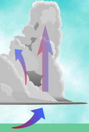
Upward currents, updrafts, are very important factors in determining the weather around us. Many clouds form in upward air currents, particularly those bubbling cloud masses of the cumulus cloud family. As discussed in another essay, "Making Clouds and Rain," one required ingredient for precipitation in all its forms is ascending air. But, updrafts also allow many air constituents, such as heat, moisture and contamination, to be raised off the planet's surface and mixed into larger air masses, thus keeping the troposphere a rather well-mixed volume of air.
The general definition for updraft is "a rising current of air," although the term is often limited to upward moving currents within large cumulus clouds and thunderstorms. Storm updrafts are the athletic big brothers of the updraft family, reaching speeds as swift as 80 km/h (50 mph). Most of the family, in contrast, are wee folk, upward currents that rarely exceed 10 cm/sec (0.3 ft/sec) or 0.4 km/h (0.2 mph).
We can identify five main driving forces for updraft formation. Depending on the time and space scales of interest to the observer, these forces may work alone or in concert, and in some cases, one may initiate another. They are:
A sixth mechanism is so commonly discussed in most weather books, that I need to at least mention it here. The lifting of air along warm and cold frontal zones forms updrafts through the combination of convergence and buoyancy forcing (at times enhanced by divergence aloft). I consider this, however, a second-rank forcing because it combines two of the main driving forces.
Topography and density forcing are perhaps the only true forcing mechanisms. One could argue successfully that turbulence, convergence and divergence are second-rank forcing agents, themselves caused by topographical and density differences acting on different time and space scales.
Updrafts in the lower atmosphere are balanced, usually nearby, by downdrafts as the atmosphere adjust to the movement of mass. Thus, we can define the above as driving forces for downdrafts as well, partners, and at times the dominant partner, in every occurrence of updrafts. In thunderstorms, downdrafts can form strong downbursts or microbursts often misinterpreted as tornadic winds when they damage property on the surface. Generally, however, downdrafts are usually even slower than the weak updrafts, moving like a long sigh after a quicker inhalation.
Turbulence produces chaotic twists and turns in a fluid flow such as the wind. Turbulent flow is the opposite of smooth (laminar) flow in which the fluid elements appear to be a uniformly flowing marching band in strict formation. Turbulent flow acts more like the plays unfolding on the football field with elements (players) moving about the field in a seemingly random pattern. Turbulence can be defined on any time or space scale but usually is considered to act primarily on the small microscales of time and space, but that is not a hard and fast rule. For example, to someone focused on planetary-scale climate elements, transitory low pressure systems could be considered as turbulence in the system's flow.
Turbulent wind flow causes large, rapid variations in wind speed, whereas low turbulence or laminar flow changes little over time.
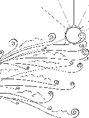
Some turbulent updrafts in small-scale flow are caused by the wind flowing over rough surfaces, such as a rocky or vegetated landscape, and reacting to the unevenness. On the microscale, these roughness elements are small topographical variations, ranging from trees and buildings down to barely visible sand grains and dirt clumps.
To get a view of this turbulence in action, watch soap bubbles or smoke dance, rising and falling, on a light wind day as they move downwind with the current. The bubbles may rise to cross a fence or hedge, drop a bit on the other side, or race up the face of a building or tree and then drift away high above the ground. Or they may twist and turn among vegetation or other small, scattered obstacles, like a running back avoiding tacklers.
Other turbulent updrafts arise when uneven heating or other processes produce small, light parcels of air that rise randomly across the landscape. This turbulence arises from density differences among air parcels altering the buoyancy forces acting in the fluid. More on this below.
In the next segment, we will look at the role of topography and buoyancy in forming updrafts.
Learn More From These Relevant Books Chosen by The Weather Doctor
For More Weather Doctor articles, go to our Site Map.
I have recently added many of my lifetime collection of photographs and art works to an on-line shop where you can purchase notecards, posters, and greeting cards, etc. of my best images.


 Upward currents, updrafts, are very important factors in determining the weather around us. Many clouds form in upward air currents, particularly those bubbling cloud masses of the cumulus cloud family. As discussed in another essay, "
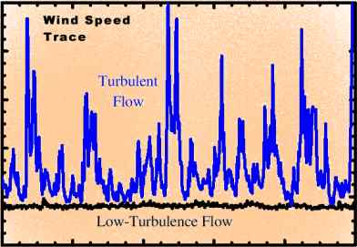
 To get a view of this turbulence in action, watch soap bubbles or smoke dance, rising and falling, on a light wind day as they move downwind with the current. The bubbles may rise to cross a fence or hedge, drop a bit on the other side, or race up the face of a building or tree and then drift away high above the ground. Or they may twist and turn among vegetation or other small, scattered obstacles, like a running back avoiding tacklers.