The driving forces of convergence and divergence are usually large-scale processes which help create high and low pressure cells and fronts, but they can form updrafts on the regional, mesoscale or microscale as well.
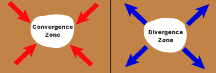
Convergence is the process whereby streams of elements come together into a much smaller central area, either by opposing flow directions or by some faster elements catching up to those ahead. Since I am writing this in Spring, imagine we are in a blimp flying over Wrigley Field on Opening Day of the baseball season. Hours before the game begins, we can see from our lofty vantage point the fans coming toward -- converging on -- Wrigley Field from all over Chicagoland.
As the fans enter the ballpark, they are forced to come closer together until they reach a level of maximum density, the seating capacity. In order to add more fans to the crowd without making those within angry, some must move upward, into the upper deck of the grandstand. If the Cubs management wanted to add many more fans on a regular basis, they would have to build more upper levels. Thus, the convergence of people causes the upward movement of some to higher seats (elevation).
In the atmosphere, when winds converge over a relatively small area, the push of the air-molecule crowd forces those in the centre to form an upward air current, our updraft. (The solid ground below, of course, prevents the air from creating a downdraft.) Surface air convergence may be initiated by topography or solar heating or some combination. However, convergence zones also form when surface air masses, particularly those of contrasting properties -- heat/cold, moist/dry -- are forced into each other by the winds, zones we commonly call fronts.
There are many areas on Planet Earth where convergence zones can regularly be found, but none is as striking as the Intertropical Convergence Zone (ITCZ), a belt that encircles the Earth around the equator. Here, the high influx of solar energy produces rising air currents that reach into the upper atmosphere and send heat poleward into both hemispheres. The high heat, humidity and continually ascending air produces nearly constant cumulus clouds and regions of heavy rainfall under the ITCZ . Many of the world's jungles are located in the ITCZ regions.
Section of ITCZ west of Central America GOES 11 Photo courtesy NASA
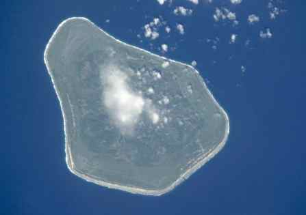
Some of the most striking, early weather satellite pictures detailed cloud-capped islands in mid-ocean, surrounded by clear skies. Here is an example of how several updraft-forming mechanisms work together. First, the rising sun heats the island surface of sand or rock much quicker than it can heat the surrounding waters. By heating the air in contact with the surface, its density is lowered, the air rises, and a small region of relatively low pressure forms over the island, initiating a sea breeze.
Clouds forming over Mangaia I., Cook Islands Photo courtesy NASA-Johnson Space Center
Assuming the island is rather flat and of moderate areal extent, the sea-breeze winds from opposite shores will meet around mid-island, forming a convergence zone that forces the air to rise further. Once this rising column of air over the central island reaches its condensation level, cumulus clouds will form, capping the island like the wooly ball atop a toque. Thunderstorms generally develop by late afternoon with such regularity that you can set your watch.
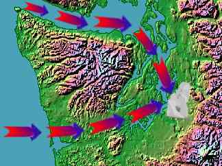
Surface-level convergence in rugged terrain can produce updraft regions, which may generate clouds and convective showers. One notable terrain-induced convergence zone is the Puget Sound Convergence Zone near Seattle, Washington. Along the coast west of Seattle, westerly winds off the Pacific Ocean have a difficult time crossing the high and rugged Olympic Mountain range. One of the easiest paths for the air to follow inland is eastward through the Strait of Juan de Fuca into the Georgian Basin and then southward through the channels of Puget Sound. Some air, however, does manage to traverse the coastal range further south, skirting some peaks, rolling over low ones, and then flowing through fjords to eventually push northward into the Sound. The favoured location where these air currents meet is called the Puget Sound Convergence Zone. Here, the rising, moist marine air produces convective rain showers that help to reinforce Seattle's wet reputation.
Warm and cold fronts are prime areas for updraft formation, combining the forcing of convergence with that of buoyancy. Along the warm front, the warm air converges on the colder air and being less dense, slides upward over the cold air. Within the cold frontal zone, on the other hand, it is the cold air converging on the warm. The cold air pushes under the warm because it is more dense, and thus it lifts the warm air aloft. Lifts at the cold front are more explosive, and the resulting updrafts more rapid, causing convective clouds to grow into thundershowers or thunderstorms.
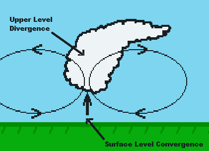
Weather forecasters look for regions of surface convergence on their weather charts because they favour the formation of convective precipitation and severe storms. The convergence of winds along a frontal boundary will often spark the development of a major extratropical cyclonic storm, particularly if an upper-level divergence zone is also present.
Divergence is the opposite situation to convergence, the moving away of elements from a common area. In our baseball example above, divergence is the moving of fans away from Wrigley Field after the game, dispersing back to their homes. Those who had been seated in the upper deck descend to street level before leaving the park before diverging.
In the lower atmosphere, surface divergence causes air to sink from above to replace that moving outward from the divergence zone, therefore surface divergence zones are the place to look for indications of downdrafts. Downdraft zones are generally characterized by clear skies or only thin cloud layers. Pancake-shaped cumulus humilis in mid-afternoon are frequently the best the sun can do to form clouds in a divergence zone.
On the other hand, high in the atmosphere, where the physical barrier of the solid surface is too far below to be effective, an elevated zone of divergence can establish an updraft region below it. Upper-level divergence that can induce sustained updrafts from the surface is one sign that severe-weather forecasters look for as an indicator of cyclone formation or severe thunderstorm potential.
Learn More From These Relevant Books Chosen by The Weather Doctor
For More Weather Doctor articles, go to our Site Map.
I have recently added many of my lifetime collection of photographs and art works to an on-line shop where you can purchase notecards, posters, and greeting cards, etc. of my best images.


 In the atmosphere, when winds converge over a relatively small area, the push of the air-molecule crowd forces those in the centre to form an upward air current, our updraft. (The solid ground below, of course, prevents the air from creating a downdraft.) Surface air convergence may be initiated by topography or solar heating or some combination. However, convergence zones also form when surface air masses, particularly those of contrasting properties -- heat/cold, moist/dry -- are forced into each other by the winds, zones we commonly call fronts.
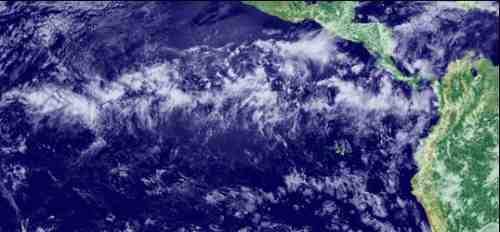
 Surface-level convergence in rugged terrain can produce updraft regions, which may generate clouds and convective showers. One notable terrain-induced convergence zone is the Puget Sound Convergence Zone near Seattle, Washington. Along the coast west of Seattle, westerly winds off the Pacific Ocean have a difficult time crossing the high and rugged Olympic Mountain range. One of the easiest paths for the air to follow inland is eastward through the Strait of Juan de Fuca into the Georgian Basin and then southward through the channels of Puget Sound. Some air, however, does manage to traverse the coastal range further south, skirting some peaks, rolling over low ones, and then flowing through fjords to eventually push northward into the Sound. The favoured location where these air currents meet is called the Puget Sound Convergence Zone. Here, the rising, moist marine air produces convective rain showers that help to reinforce Seattle's wet reputation.
 In the lower atmosphere, surface divergence causes air to sink from above to replace that moving outward from the divergence zone, therefore surface divergence zones are the place to look for indications of downdrafts. Downdraft zones are generally characterized by clear skies or only thin cloud layers. Pancake-shaped cumulus humilis in mid-afternoon are frequently the best the sun can do to form clouds in a divergence zone.