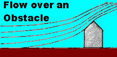
Topographical forcing of updrafts is the production of upward moving currents due to topographical features on the landscape. Any vertical step-up formed by a topographical element can induce an updraft. The airflow patterns affected by terrain features are often called orographic flows.
I here define topography in the context of topographical forcing influence to mean those variations from flat terrain that would be seen on a topographical relief map: hills and valleys; mountains and basins; canyons and shorelines. However, vegetation can also act as topography if its elements are large such as a forest or trees, shrubs, or hedges. Human structures such as cities, buildings, bridges, or fences may also be considered topography in some contexts.
Surrounded by rugged mountainous terrain rising from sea level here on Vancouver Island, I see topographical influences on updrafts more frequently than if I were a resident of flat terrain areas such as Saskatchewan, Kansas or Florida. But I was born and raised a prairie-Illinois flatlander and know that topographical influences are also visible there when you take the time to search them out.
To illustrate the effects of terrain on wind flow in forming updrafts, imagine you are piloting an aircraft flying from Hawaii toward the North American coast at an altitude lower than the coastal mountain ranges ahead. Your destination is an inland city, say Calgary or Kansas City.
If the planet had uniformly elevated continental terrain rising moderately above sea level, you would have little trouble, given fair weather, maintaining your altitude until final landing approach. Earth, however, is not so accommodating, and the western coast of North America has a series of young, tall mountain ranges that must be traversed.
As you approach the coastal mountains for your trip's overland leg, you have one logical flight plan choice: fly on an upward path to cross over those mountains. And whether you choose a long, slow, safe ascent, or a quick, dare-devilish, heart-stopping, nearly vertical climb close to the range, your flight path has an upward component which must exceed the range's greatest elevations. If you were air, this would cause you to move in an updraft: a slow ascent if taking the safe route; a rapid ascent if being the daredevil.
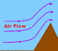
Air molecules fly similar trajectories, but having no need for safety, many airstreams approach fairly close to the mountain face before forced to ascend in a nearly vertical rise. All else being equal, the sharper the change in terrain, the faster the updraft produced by it. Steep slopes such as cliff faces and canyon walls produce strong updrafts; slow rising hills usually give rise to weaker updrafts.
Any vertical step-up formed by a topographical element will induce an updraft, unless other atmospheric conditions work in opposition, or the breadth of the obstacle (such as a pole) makes flow around easier than flow over. The absolute height of the obstacle is usually not as important as the height/width ratio, the obstacle's face slope angle, and obstacle separation in determining the upward component of the flow.
The air moving onto the continent from the flat Pacific Ocean is forced over high coastal summits through a wide spectrum of updraft speeds. The ascent pushes the damp marine air to high altitudes to form clouds and precipitation along the range's face. The chilling ascent "wrings out" much of the air's water vapour along the western faces of those ranges, thus producing the ideal wet climate conditions for the temperate rain forests that cover coastal Alaska, British Columbia and Washington.
Air currents rushing toward a steep terrain face before ascending not only enhances the formation of showers, hail and thundershowers, they are also exploited by various life forms to hitch a free ride on the winds. For example, I wrote several years ago how the local turkey vulture population uses topographically induced updrafts to cross the 18-20 km (11-12.5 mile) width of the Strait of Juan de Fuca from Vancouver Island to Washington on their winter migration.
Gulls and other sea birds will use updrafts along the shore to get a push upward and can even exploit the air currents above the ocean waves to glide nearly effortlessly for hours. To do this, they catch the small updraft on the windward wave face that catapults them to a higher altitude. Gliding slowly downward under the force of gravity, they seek another vertical push just before reaching the wave surface.
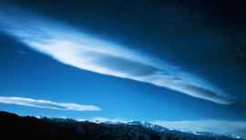
Clouds are good indicators of topographical updraft regions, forming regularly over mountains or hills and often appearing to remain stationary despite a strong wind. Such clouds are called cap clouds or banner clouds, formed where the ascending air reaches its condensation level near the ridge line. When the airstream descends in the lee of the ridge, the cloud droplets that it carries again evaporate, and the cloud dissipates. To the casual observer, the cloud appears to remain fixed over the mountain, but concentrated viewing or use of time-lapse cinematography would reveal the cloud to be a fluctuating body that changes shape and size as the air parcels move into and out of the condensation zone.
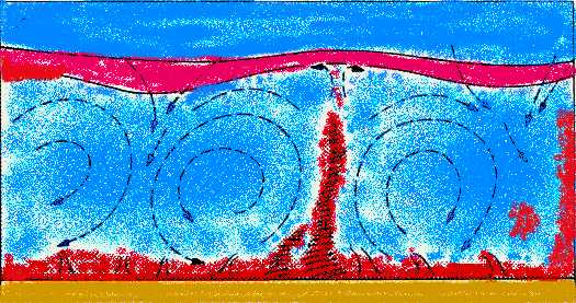
Air density forcing, also called buoyancy or buoyancy forcing, uses density differences between an air parcel and its surroundings to produce updrafts. (Usually buoyancy refers to upward motions, such as when you dive into a pool and are pushed upward toward the surface, and negative buoyancy is used to denote density forces producing downdrafts.) Air density variations can initiate surface updrafts on the flattest of terrains or updrafts residing within a column of air far removed from any topographical influences. Buoyancy forcing often enhances topographically produced updrafts, particularly when the air's water vapour condenses on ascent.
Updrafts (in red) rise as ground surface is heated by the sun above ambient air temperatures (blue).
Warm air is light air, and the density difference between a warm air parcel and its cooler environment causes it to rise. How far and how fast it rises depends on the parcel's properties and the temperature stratification of the air column in which it resides. As long as the rising air parcel is less dense than that around it, it will continue to rise. However, in rising, it cools and eventually reaches an equilibrium density with its surroundings, bringing the updraft to a halt.
The water vapour content, its absolute humidity, of an air parcel also affects its density. All other factors being the same, a volume of air with greater water vapour content will be lighter than a similar, drier volume. In addition, when water vapour condenses to a liquid or forms solid ice within an ascending air parcel, it releases heat (the latent heats of condensation and deposition, respectively) into the parcel, which now becomes warm and thus, less dense. The conversion of water from vapour to liquid or solid often promotes the formation of tall cumulus clouds and thundershowers. Under extreme situations, it can be the spark for severe thunderstorm development.
A parcel of air therefore ascends into the atmosphere if its temperature or humidity is increased by some means to reduce its density. What are some of those mechanisms?
Solar heating is one of the most common processes by which air in contact with the surface is heated. Flow over relatively warm surfaces, such as warm water bodies or rocks in which heat has been stored, can heat the air. Air may also be heated by internally generated earth processes (volcanoes, hot springs, etc.), human activities (manufacturing, building heating, power generation, etc.), and fire (forest, grass, buildings, etc.).
Evaporation from wet soils or standing water, plant transpiration, human activities (agriculture, irrigation), or precipitation falling within an air mass adds water vapour and thus lowers the density of the air parcel.
In the next segment, we will look at the role of convergence and divergence in forming updrafts.
Learn More From These Relevant Books Chosen by The Weather Doctor
For More Weather Doctor articles, go to our Site Map.
I have recently added many of my lifetime collection of photographs and art works to an on-line shop where you can purchase notecards, posters, and greeting cards, etc. of my best images.


 Topographical forcing of updrafts is the production of upward moving currents due to topographical features on the landscape. Any vertical step-up formed by a topographical element can induce an updraft. The airflow patterns affected by terrain features are often called orographic flows.
 Air molecules fly similar trajectories, but having no need for safety, many airstreams approach fairly close to the mountain face before forced to ascend in a nearly vertical rise. All else being equal, the sharper the change in terrain, the faster the updraft produced by it. Steep slopes such as cliff faces and canyon walls produce strong updrafts; slow rising hills usually give rise to weaker updrafts.
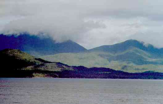
 Clouds are good indicators of topographical updraft regions, forming regularly over mountains or hills and often appearing to remain stationary despite a strong wind. Such clouds are called cap clouds or banner clouds, formed where the ascending air reaches its condensation level near the ridge line. When the airstream descends in the lee of the ridge, the cloud droplets that it carries again evaporate, and the cloud dissipates. To the casual observer, the cloud appears to remain fixed over the mountain, but concentrated viewing or use of time-lapse cinematography would reveal the cloud to be a fluctuating body that changes shape and size as the air parcels move into and out of the condensation zone.