| Home | Welcome | What's New | Site Map | Glossary | Weather Doctor Amazon Store | Book Store | Accolades | Email Us |
 | |||||||||||||||||||||||||||||||||||||||||||||||||||||||||
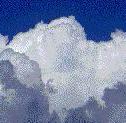
Making Clouds and Rain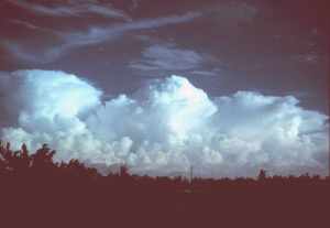 Although the formation of clouds and precipitation can be quite complex in full detail, we can simplify the process into a simple recipe, good for the vast majority of situations. Building CloudsFirst, we need two basic ingredients: water and dust. On Planet Earth, naturally occurring clouds are composed primarily of water in its liquid or solid state. (On other planets, clouds may form from other compounds such as the sulphuric acid clouds on Venus.) Thus, we begin our recipe by collecting a sufficient quantity of water in the vapour state that we will soon transform into the liquid or solid states. The water vapour content of the atmosphere varies from near zero to about 4 percent, depending on the moisture on the surface beneath and the air temperature. Next, we need some dust. Not a large amount nor large particles and not all dusts will do. Without "dirty air" there would likely be no clouds at all or only high altitude ice clouds. Even the "cleanest" air found on Earth contains about 1000 dust particles per cubic metre of air. Dust is needed for condensation nuclei, sites on which water vapour may condense or deposit as a liquid or solid. Certain types and shapes of dust and salt particles, such as sea salts and clay, make the best condensation nuclei. With proper quantities of water vapour and dust in an air parcel, the next step is for the air parcel mass to be cooled to a temperature at which cloud droplets or ice crystals can form. And, voila, we have clouds. This simple recipe is a lot like cooking chicken -- you take a chicken and some spices, apply heat and after a time you have a cooked chicken. But just as there are many ways to cook chicken, there are many different ways to form clouds.
Let us now expand our recipe and add precipitation.. Professor John Day, the Cloud Man, has taken the simple cloud recipe, added a few more details and continued it until it also makes precipitation. He calls this The Precipitation Ladder. As with our simple recipe, he begins the process with the basic ingredients of dirty air and water vapour. In Rungs 3 through 8, he takes the ingredients through several processes to form a cloud. Ascent and Expansion are two of the main processes that result in the cooling of an air parcel in which clouds will form. We mostly think of moving air as wind flowing horizontally across the surface. But air moving vertically is extremely important in weather processes, particularly with respect to clouds and precipitation. Ascending air currents take us up the Precipitation Ladder. (Where descending currents are present, we come down the Ladder with processes reversing until we are finally left with water vapour and dust in an air mass.) There are four main processes occurring at or near the earth's surface which give can rise to ascending air: convergence, convection, frontal lifting and physical lifting. Convergence occurs when several surface air currents in the horizontal flow move toward each other to meet in a common space. When they converge, there is only one way to go: Up. A surface low pressure cell is an example of an area of convergence and air at its center must rise as a result. Convection occurs when air is heated from below by sunlight or by contact with a warmer land or water surface until it becomes less dense than the air above it. The heated parcel of air will rise until it has again cooled to the temperature of the surrounding air. Frontal lifting occurs when a warmer air mass meets a colder one. Since warm air is less dense than cold, a warm air mass approaching a cold one will ascend over the cold air. This forms a warm front. When a cold air mass approaches a warm one, it wedges under the warmer air, lifting it above the ground. This forms a cold front. In either case, there is ascending air at the frontal boundary. Physical lifting, also known as orographic lifting, occurs when horizontal winds are forced to rise in order to cross topographical barriers such as shorelines, hills and mountains. Whatever the process causing an air parcel to ascend, the result is that the rising air parcel must change its pressure to be in equilibrium with the surrounding air. Since atmospheric pressure decreases with altitude, so too must the pressure of the ascending air parcel. As air ascends, it expands. And as it expands, it cools. The higher the parcel rises, the cooler it becomes. Now that we have begun cooling the air parcel, we are almost ready to form a cloud. We must continue to cool the parcel until condensation is reached. The next several rungs of the Precipitation Ladder describe the processes through to the condensation of liquid water. As the air cools, its relative humidity will increase — a process Day terms humidification (Rung 6). Although nothing has yet happened to change the water vapour content of the air, the saturation threshold of the air parcel has decreased as the air cooled. By decreasing the saturation threshold, the relative humidity increases. Cooling is the most important method for increasing the relative humidity but it is not the only one. Another is to add more water vapour through evaporation or mixing with a more humid air mass. If we are to form a cloud, humidification must eventually bring the air within the parcel to saturation or close to it. At saturation the relative humidity is 100 percent. Usually a little more humidification is required which brings the relative humidity to over 100 percent, a state known as supersaturation, before a cloud will form. When air becomes supersaturated, its water vapour looks for ways to condense out. If the quantity and composition of the dust content is ideal, condensation may begin at a relative humidity below 100 percent. If the air is very clean, it may take high levels of supersaturation to produce cloud droplets. But typically condensation begins at a relative humidity a few tenths of a percent above saturation. Condensation of water onto condensation nuclei (or deposition of water vapour as ice on freezing nuclei) begins at a particular altitude known as the cloud base or lifting condensation level. Water molecules attach to the particles and form cloud droplets which have a radius of about 20 micrometres (0.02 mm) or less. The droplet volume is generally a million times greater than the typical condensation nuclei. Clouds are composed of large numbers of cloud droplets, or ice crystals, or both. Because of their small size and relatively high air resistance, they can remain suspended in the air for a long time, particularly if they remain in ascending air currents. The average cloud droplet has a terminal fall velocity of 1.3 cm per second in still air. To put this into perspective, the average cloud droplet falling from a typical low cloud base of 500 metres would take more than 10 hours to reach the ground.
Prior to the beginning of the Nineteenth Century, most weather observers believed that clouds were too transient, too changeable and too short-lived to be classified or even analyzed. With few exceptions, no cloud types were even named; they were just described by their colour and form as each individual saw them: dark, white, grey, black, mare's tails, mackerel skies, wooly fleece, towers and castles, rocks and ox-eyes. Clouds were used as forecast tools in weather proverbs, but mostly by their shape, state of darkness or colour: "Red sky in morning, sailor take warning." "Mackerel skies and mare's tails, make lofty ships carry low sails." The first widely accepted categorization of clouds was assembled by Luke Howard in 1802 or 1803. Howard believed that clouds could be identified by four simple categories within the complexity of cloud forms.
Clouds could also alter their forms, Howard reasoned. Thus, when cumulus clouds bunched together so that they crowded the sky, they became Cumulo-stratus (what are called today stratocumulus). Howard�s classification was accepted by the international meteorological community in 1894, with some additional terms, such as alto (meaning "middle") to designate the altitudes where clouds formed. We now know that cirrus clouds in their various forms are composed of ice crystals, and the upper levels of tall cumulus may also have ice in them even in the summer. While clouds in their varied forms and appearances (See Cloud Atlas) are a source of much interest, we will leave them now and continue up the Precipitation Ladder toward the top rung: Precipitation. Forming Precipitation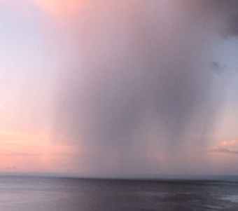 We know that not all clouds produce rain that strikes the ground. Some may produce rain or snow that evaporates before reaching the ground, and most clouds produce no precipitation at all. When rain falls, we know from measurements that the drops are larger than one millimetre. A raindrop of diameter 2 mm contains the water equivalent of a million cloud droplets (0.02 mm diameter). So if we are to get some precipitation from a cloud, there must be additional process within the cloud to form raindrops from cloud droplets. The next rung of the Precipitation Ladder is Buoyancy or Cloudiness which signifies that we must increase the cloud water content before we can expect any precipitation. This requires a continuation of the lifting process. It is assisted by the property of water of giving off heat when changing from vapour to liquid and solid states, the latent heats of condensation and of deposition, respectively. (If the vapour first changes to a liquid before freezing, then we also have the latent heat of condensation released and followed by the release of the latent heat of freezing.) This additional heat release warms the air parcel. In doing so, the buoyancy of the parcel relative to the surrounding air increases, and this contributes to the parcel's further rise. We can see the continued ascent of these parcels in cumulus clouds that reach great vertical growth. Now in the cloud, there must be Growth of cloud droplets to sizes that can fall to the ground as rain (we will look at snow in a minute) without evaporating. Cloud droplets can grow to a larger size in three ways. The first is by the continued condensation of water vapour into cloud droplets and thus increasing their volume/size until they become droplets. While the first condensation of water onto condensation nuclei to form cloud droplets occurs rather quickly, continued growth of cloud droplets in this manner will proceed very slowly. Second, growth by collision and coalescence of cloud droplets (and then the collision of rain drops with cloud droplets and other drops) is a much quicker process. Turbulent currents in the clouds provide the first collisions between droplets. The combination forms a larger drop which can further collide with other droplets, thus growing rapidly in size. As the drops grow, their fall velocity also increases, and thus they can collide with slower falling droplets. A 0.5 mm-radius drop falling at a rate of 4 m/s can quickly overtake a 0.05 mm (50 micrometre) drop falling at 0.27 m/s. When drops are too large, however, their collection efficiency for the smallest drops and droplets is not as great as when the drops are nearer in size. Small droplets may bounce off or flow around much larger drops and therefore do not coalesce. A drop about 60% smaller in diameter is most likely to be collected by a large drop. Clouds with strong updraft areas have the best drop growth because the drops and droplets stay in the cloud longer and thus have many more collision opportunities. Finally, it may seem odd, but the best conditions for drop growth occur when ice crystals are present in a cloud. When in small droplet form, liquid water must be cooled well below 0oC (32 oF) before freezing. In fact, under optimal conditions, a pure droplet may reach -40 oC (or oF) before freezing. Therefore, there are areas within a cloud were ice crystals and water droplets co-exist. When ice crystals and supercooled droplets are near each other, there is a movement of water molecules from the droplet to the crystal. This increases the size of the ice crystal at the expense of the droplet. When the crystals grow at temperatures around -10 oC (14 oF), they begin to develop arms and branches, the stereotypical snow crystal. Such crystals not only are efficient at growing at the expense of water droplets, they also easily stick to one another forming large aggregates we call snowflakes. Finally, the drops have grown to a size that they can fall in a reasonable time to the surface without evaporating, and we have reached the top rung Precipitation. (For more on raindrops, click here.)The following table gives some typical drop diameters for various rain types, using cloud droplets as a reference size. Most rain falls in the range of 0.2 to 5 mm (0.008 to 0.20 inch).
Of course, not all precipitation falls as rain. A fair amount of the world's precipitation falls as snow or some other solid water form. Actually, outside the tropical regions, it is likely that the much of the precipitation begins in the solid form and only becomes liquid rain when it melts while falling through air with temperatures above freezing. Most people call almost any frozen form of precipitation, other than hail or ice pellets, a snowflake. But meteorologists are a bit more fussy. Technically the term snowflake refers to an assemblage of individual snow crystals that have bumped together and remain joined during their fall. Snowflakes typically fall when air temperatures near the earth's surface are not far from the freezing mark. Snow crystals adhere to each other better at these temperatures. At very cold temperatures, snowflakes are uncommon and we see mostly snow crystals during a snow fall. Snow crystals are typically 0.5 to 5 millimetres ( 0.02 to 0.20 inches) in size whereas snowflakes are about 10 mm in size (0.4 inches) and may be as large as 200 to 400 mm (0.79 to 1.57 inches). Other common forms of solid precipitation are: hail, sleet or ice pellets, graupel or soft hail or snow grains, and a special form: freezing rain, also known as glaze or rime. The latter falls as a liquid but freezes on contact with an object. When clear ice forms, freezing rain is called glaze. When the ice is milky, it is called rime. Hail is a phenomenon of severe thunderstorms, requiring strong updrafts to form hailstones by passing the hailstone seed many times through air laden with drops and ice crystals. Learn More From These Relevant Books
|
|||||||||||||||||||||||||||||||||||||||||||||||||||||||||
 |
To Purchase Notecard, |
Now Available! Order Today! | |
 |
 |
NEW! Now Available in the US! |
The BC Weather Book: |