| Home | Welcome | What's New | Site Map | Glossary | Weather Doctor Amazon Store | Book Store | Accolades | Email Us |
 | |||||||||
Lake Breeze Weather
On late spring and summer days when the temperature soars, a special wind system may form along the coastline of the Great Lakes or other large lakes. It is known as the lake breeze, a similar condition to the sea breeze known along ocean shores. The lake breeze forms during daylight in the late spring and summer months because Great Lake waters do not warm as quickly as the surrounding land surfaces. Air cooled by contact with the cold lake waters is denser than that surrounding the lake and thus forms a cell of relatively high pressure over the lake. When the sun heats the land, the air above it warms becoming less dense. Thus, solar heating produces a wide region of lower pressure over the land. With high pressure over the lake and low pressure over land, the regional pressure gradient pushes winds inland off the lake. This is the lake breeze flow. 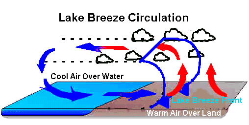 Lake Breeze Circulation SystemThe formation of the lake breeze depends on two main factors: the air temperature contrast between the lake and surrounding land ? which defines the local pressure gradient ? and the strength of the regional wind caused by continental pressure differences, which can counter the lake-land differential. The strongest lake breezes, those above 25 km/h (15 mph), with the furthest inland penetration, 40 kilometres (25 miles), generally occur during late spring hot spells when lake waters are still winter cold while the land is simmer warm. Since lake water temperature changes very slowly, solar heating of land creates the temperature differential necessary to form the lake breeze around mid-morning. Clear morning skies and light winds are the most favorable weather conditions for lake breeze formation. If the regional wind is too strong, it prevents the formation of the required pressure gradient to drive the lake breeze. When the sun's heating diminishes in late afternoon, so does the lake breeze as the land begins to cool. However, around large lakeside cities such as Chicago or Toronto, solar heat stored in urban concrete and steel may permit the lake breeze to continue blowing into the evening hours. The Lake Breeze FrontWe have all experienced cold fronts that sweep by with the passage of large-scale storm systems. A cold front can also occur on a more local scale. When the lake breeze forms and brings the colder lake air onto the land, the boundary zone between the two air masses ? lake air and land air ? is known as the lake breeze cold front, or simply the lake breeze front. If you are standing near the shoreline of a large lake such as Lake Michigan, you should be able to feel the lake breeze front pass you. The air becomes notably cooler (and often perceptibly moister), the wind direction shifts, and a gusty breeze arises from the direction of the lake. The lake breeze frontal zone is quite narrow (1-2 km wide) and often moves slowly enough that you can walk back and forth across it from the warm land air to the cool lake air, a most interesting experience. How far the lake breeze front penetrates inland depends on the temperature contrast between the land air temperature and that over the lake. Meteorologists have recorded inland penetration as far as 40 kilometres (25 miles), but 16 km (10 miles) is more typical. At the upper levels of the lake breeze front, cumulus clouds often form and, when the conditions are right, thunderstorms can pop up along the frontal zone. Lake Breeze Thunderstorms
The region of southwestern Ontario along a line from Detroit to Toronto is bounded by Lake Huron to the north and Lake Erie to the south. Lake breeze fronts often move in from both lakes and approach each other. The two frontal advances push the warm, humid land air into a narrow, and often stationary, convergence zone, forcing it to rise upward. This convergence first forms bands of cumulus clouds, some of which can grow into lake breeze thunderstorms when conditions are ripe. 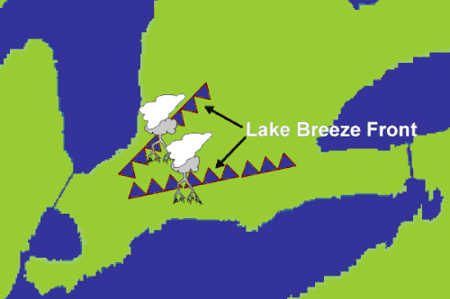 Lake Breeze Thunderstorm Forming along Lake Breeze FrontRecently, scientists in Ontario, Canada documented a severe thunderstorm triggered by lake breezes flowing off Lakes Erie and Huron and converging over southwestern Ontario. During the field research study, named ELBOW, into lake breeze thunderstorms, meteorologists observed a thunderstorm born between the converging lake breeze fronts quickly grow into a severe storm in about 20 minutes. A spotter team experienced heavy rain, downed trees and flooded roads and fields from the storm. Local radar estimated that 200 mm (8 inches) of rain fell at the small crossroads community of Punkeydoodle Corners over a five-hour period from this stationary thunderstorm storm cell. 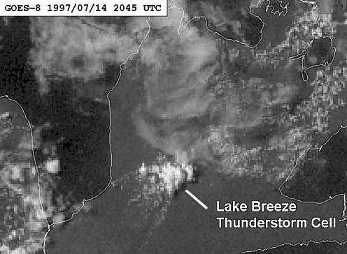 Satellite View of Southern Ontario Storm: 14 July 1997 |
|||||||||
 |
To Purchase Notecard, |
Now Available! Order Today! | |
 |
 |
NEW! Now Available in the US! |
The BC Weather Book: |


 I have previously written on the impact of the Great Lakes region on autumn and winter storms. but the Lakes have equally major impacts on spring and summer weather in its basin. On late spring and summer days when the temperature soars, a special wind system may form along the coastline of the Great Lakes or other large lakes. It is known as the lake breeze, a similar condition to the sea breeze known along ocean shores.
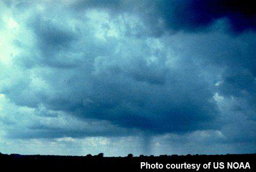 Thunderstorms are triggered by a wide variety of atmospheric interactions, including those along the lake breeze front. The development of thunderstorms requires quantities of low-level moisture, deep layers of conditional atmospheric instability which when triggered allow the development of towering cumulonimbus clouds, and significant upward vertical motion which provides the trigger. A hot, humid summer day can usually provide the first two ingredients, but the third ingredient is often missing. This can be provided by the lake breeze front. Rising air motions at the frontal boundary induce the lift required to initiate thunderstorm development.