| Home | Welcome | What's New | Site Map | Glossary | Weather Doctor Amazon Store | Book Store | Accolades | Email Us |
 | |||||||||||||
Weather Almanac for September 2002THE FOG ROLLS INAs I was heading home around the bewitching hour recently, I noted that the clear sky above was more hazy as I looked toward the horizon. Dew was beginning to form on the windshield so I knew that the air was fairly close to saturated.
This specific type of fog is termed radiation fog and is quite common across Canada and the USA, particularly in the Autumn season. Fog, however, comes in many flavours, depending on the prevailing large scale weather regime, location and topography. Radiation fog's cousins frontal fog and members of the advection fog family also find the year's last quarter conducive for a visit. What Is Fog?Although we may not recognize it as such, fog is actually a cloud formed or lying on the ground — even those patchy fogs which fill low spots or hollows in the terrain are cloud fragments. Fogs form when air saturates (its relative humidity reaches around 100 percent), and the water vapour within the air mass condenses on small particles in the air to form liquid cloud droplets. The air may become saturated either by lower its temperature to its condensation (dew) point or by adding water vapour into the air until it reaches saturation. [For more on water vapour in the air, see my article: Sometimes It's Relative: Humidity.] Fog is technically defined — for weather observing purposes — as "an obscurity in the surface layers of the atmosphere which is caused by a suspension of water droplets, with or without smoke particles present, and which is defined by international agreement as being associated with visibility less than 1000 metres (1090 yards or 0.62 miles)." But, often we see fog patches that dot the landscape or hang over one area of the surroundings. This too is fog even when it does not fit the visibility requirement (though it likely would from within). 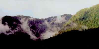 Fog forming on mountain slopes spirals and puffs like the woods are on fire. Fog formation depends very strongly on two characteristics of the air mass in which it forms. Foremost is the humidity, the amount of water vapour present in the air. If the air mass is very dry, its likelihood of producing fog is slight. To form the fog, the air mass must be brought to a saturation condition with respect to its humidity and temperature. Thus, more and more water vapour be can add until the air becomes saturated, or the air can cool until its temperature reaches the saturation point. At saturation, water vapour begins to form liquid water droplets which comprise the fog we see. Cloud droplets that form fog and clouds are very small, only around 1 to 20 micrometres in diameter, and thus they fall to the ground very, very slowly. This allows fog and clouds to seemingly hang suspended in the air. But if the air warm slightly or mixes with drier air, the liquid water can return to the vapour state. That is why fogs often quickly dissipate with the morning sun or an increase in the wind. As a result of this delicate balance, cloud/fog edges are tenuous and ever changing. The condensation of water vapour in an air mass through cooling can be produced by several mechanisms, the most common three are:
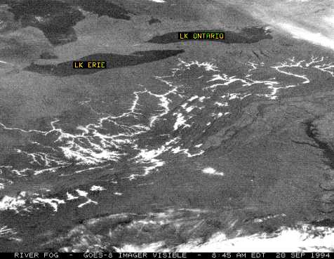
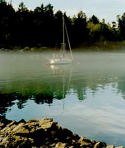
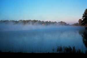
As mentioned, there are several types of fog, formed by variations in the cooling/condensation process. Radiation fog and frontal fog are perhaps the most common fog types in those areas away from large water bodies. In hilly or mountainous terrain, one might experience upslope or valley fogs. Over and near water, the water body influences either the temperature or the moisture content of air masses over it and along the shore. These fogs are usually classed as advection fogs or sea fogs. Depending on how a particular fog forms, it can rise or fall or roll in, or even just envelop. In the following sections I look at each of these. Radiation FogRadiation fog generally forms when the air near the surface cools to its saturation temperature due to radiational cooling at night when the sun has set. [For more on radiational cooling, see my background piece: Balancing Radiation.] A typical scenario for radiation fog would proceed in this manner. We start with a clear evening with moderate or high humidity and light winds. As the sun's energy diminishes at dusk, the ground surface radiates its heat away faster than it can gain it from other sources, and thus its temperature drops. The cool surface then cools the air in contact with it. Throughout the night, the surface and overlying air continue to cool (unless warmer air moves in, or a cloud deck forms above); the degree of cooling depends on several factors including cloud cover, wind speed and number of hours of darkness. 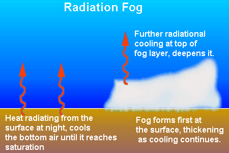 If the air reaches its condensation, or dewpoint, temperature during that nocturnal cooling, fog will form. A wet surface — moist soil or pools of standing water — significantly increases the chances of radiation fog formation, so the radiation fog potential is high after a rainfall, particularly if followed by a cold front which clears the skies and lowers the air temperature. Radiation fog is not as common over water surfaces since the cooling of the water surface by radiation is much slower during the night than the cooling occurring over the land. The radiation fog layer may vary in depth and its horizontal extent from shallow scattered patches formed in surface depressions to a general blanket as much as 300 metres (1000 feet) in depth. Visibility within the fog drops to less than 1 kilometre (5/8 mile) as the density of water droplets in the air increases. With further cooling and more condensation, the fog layer becomes optically denser, often reducing visibility to the proverbial "can't see hand in front of face" density. Often, and particularly in autumn when long nights are conducive to deep cooling, we see patchy fog in the countryside form in low areas of the terrain. These are preferred fog locations because cold air, being denser than warmer air, flows like water toward the lowest point in the terrain. Therefore, if there is any slope to the land, such as water drainage channels or hillsides, the cooler air will flow into the lowest elevation points. Radiation fog dissipates when the air mass is reheated, or the wind increases speed and mixes the moist, foggy air with warmer or drier air around it. Where fog is thin, morning solar radiation can penetrate to the ground and heat the underlying surface, thus evaporating the fog from below, a process that can be rapid in summer and excruciatingly slow during winter. Nocturnal radiation fogs often bypass cities, while rather thick fog forms in surrounding rural and suburban zones, because the city produces and holds heat much better than the more open, vegetated suburbs, and thus the city does not cool as deeply overnight. (The air over a city is also often slightly drier than that in the environs.) Advection FogsAdvection fogs are fogs formed when air moves either over a cooler surface or over a warmer, moist surface, and as a result the air mass reaches saturation. Most often this occurs when a moist air mass moves over a cold surface, such as a large, cold body of water or snow/ice cover, whose temperature is below the dew point of the advecting air mass, and its lowest reaches are cooled to condensation. 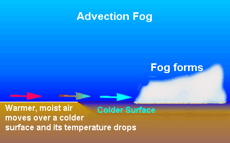 The formation of advection fogs is enhanced when the distance (fetch) over which the advecting air moves is large. A low wind speed heightens the likelihood as the air remains in contact with the surface long enough to cool the air layer sufficiently. Advection fogs are often persistent since the weather situation that forms them can last a day or more. Usually, either a frontal passage and change of air-mass or a major change in wind direction are needed for dissipation of advection fog to take place. 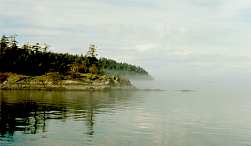 Evaporation advection fogs occur when a cool or cold air mass crosses a relatively warm water body and has water vapour evaporate into it. Often, such fogs are caused by cold air outbreaks off land crossing large water bodies such as the sea or large lakes. Such advection fogs are often referred to as sea fog, and are common offshore in winter. Sea fog is sometimes called sea smoke because it rises from the water surface in plumes of moist air that resemble smoke. Upslope and Valley FogsUpslope and valley fogs are two special cases, in my mind, of advection fogs particular to hilly terrain. They form when air moving in hilly or mountainous terrain cools to condensation. For example, when air tries to move over a terrain obstacle, it cools to some degree as it rises, the degree of cooling depending on the amount of rise. During that cooling, if the air temperature falls below the dew point, the resulting condensation will form a cloud. If that cloud hugs the ground, it becomes fog at that surface. For example, an air mass moving over a water body may gain moisture until it is very near its saturation level. While still over the water, it may not cool enough to reach condensation, but when forced over the shore, the rise from water level may cause enough cooling to form a cloud/fog. 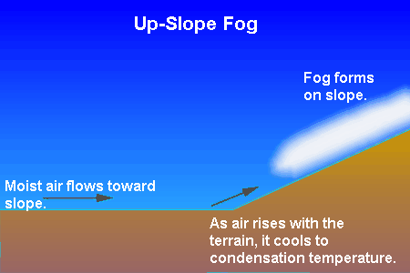 When we see clouds hugging a mountain summit, you can be sure it is foggy on the mountainit embraces. In areas like the raincoast of the Pacific Northwest of North America, upslope movement of moist Pacific air can cause extensive fog at higher elevations which disappears when the air descends on the lee of the ranges. 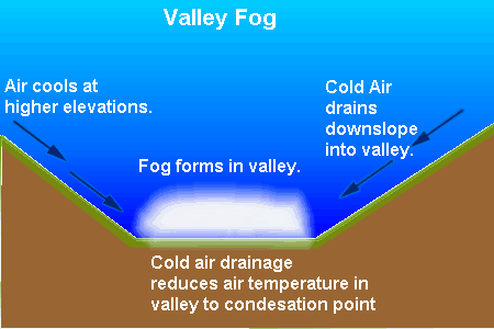 Valley fogs form when the air near the terrain heights cools — usually by radiation at night — and descends through its greater density into the surrounding valleys, flowing like water. Pooled in the valley, the cold air may condense the water vapour present into a fog which fills the valleys to a depth. Satellite photographs show the dramatic regionality of valley fog, bright fingers of fog lying between mountain ridges.
Frontal/Precipitation FogThe final fog type I wish to address is frontal fog, which may also be called precipitation fog. This fog type generally occurs when rain falling from warm air aloft evaporates at or near the surface under light wind conditions. The evaporating precipitation as it falls through colder air thus increasing the surface air's moisture burden until condensation is achieved. Such fogs are most common in the vicinity of warm or stationary fronts, but they can form at cold fronts as well. However, cold fronts generally move and mix too quickly to allow the condition to persist for long. 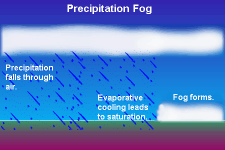 Precipitation fog can also occur under other conditions, such as beneath an area where rain falls from air driven upslope over terrain. It may also form briefly in areas where hot surfaces are quenched by showers. In this situation the hot surface forces evaporation of the rain hitting it and the vapour mixes with the cool air surrounding the falling rain to become over-saturated. A Foggy SituationBecause of its obscuring nature, fog is often used as a metaphor for the hidden, unknown or unclear. Poet Emily Dickenson's last words were reported to be: "The fog is rising." Its image fills literature and poetry and song. But fog as fog has its own place in the hearts of many writers. My favourite, and perhaps the best known, is Carl Sandburg's short poem Fog.
[For more on how various writers have viewed fog, see The Elders Speak: On Fog on this site.] Even before my eyelids rose to greet the dawn, I knew fog had settled over the city. The repeated moan of the Victoria Harbour foghorn had been my distant town crier, spreading the news over the sleepy city. When I first looked out my window, the fog was thick around me and closed around the neighbourhood. Trees and buildings only tens of metres distant were swallowed by the fog's embrace. I settled back and enjoyed a few more minutes of sleep. Learn More From These Relevant Books
|
|||||||||||||
 |
To Purchase Notecard, |
Now Available! Order Today! | |
 |
 |
NEW! Now |
The BC Weather Book: |


 I suspected that fog would form around the area overnight, perhaps only hours after I closed my eyes for the
night. The sun's tenure in the day is declining steadily now, headed for that equinox date when it will
relinquish majority control to the night. Fogs form frequently during this time of year because with the longer
night hours, the earth's surface can cool for a longer time during clear and calm nights. When the cooling
reaches the dew point, fog forms across the land.
I suspected that fog would form around the area overnight, perhaps only hours after I closed my eyes for the
night. The sun's tenure in the day is declining steadily now, headed for that equinox date when it will
relinquish majority control to the night. Fogs form frequently during this time of year because with the longer
night hours, the earth's surface can cool for a longer time during clear and calm nights. When the cooling
reaches the dew point, fog forms across the land.