| Home | Welcome | What's New | Site Map | Glossary | Weather Doctor Amazon Store | Book Store | Accolades | Email Us |
 | |||||||||||||||||||||||||||||||||||||||||||||||||||||||||||||||||||||||||||||||||||||||||||||||||||||||||||||||||||||||||||||||||||||||||||||
Weather Almanac for November 2009ALONG THE FRONT: WHERE AIR MASSES MEETBack in August 2008, I wrote an Almanac piece on the Bergen School whose members revolutionized weather analysis and prediction a century ago with their cyclone model and its associated weather fronts. In the original paper that introduced the wave cyclone model, the authors originally referred to the convergence line that separated cold air from the warm to the west and north of a low pressure center as the squall line and the line between the warm and cold air to the low's south and southeast, as the steering line. In 1920, these two lines became known as the cold front, and the warm front, respectively. 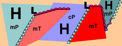 In this month’s Almanac, I will look at the basic concept of fronts, particularly the four main fronts associated with the cyclonic wave of a low pressure system: the stationary front, the warm front, the cold front, and the occluded front as well as the dew point front and some mesoscale fronts. At The FrontThe practice of referring to the boundary zone where two or more air masses meet as fronts began with Jacob Bjerknes who compared of the clash of air masses to the battle fronts of the recently concluded Great War in Europe. The symbols we now use on weather maps to depict these fronts arose from a correspondence from fellow meteorologist Tor Bergeron, who proposed the designation, to Bjerknes and in their basic form continue in use today, familiar to all who watch televised weather reports or see a daily weather map in their newspapers. While cold fronts and warm fronts are the most recognizable of the weather fronts, the initial “front” in the idealized wave cyclone model was the polar front, the nearly continuous boundary across the hemispheres between air masses of polar origin and those of tropical origin. In the beginning states of a wave cyclone cycle, the polar front acts as a stationary front where polar and tropical airs are separated by an unmoving boundary with cold air to the north and warm to the south. Along the front, a zone of temperature transition, a discontinuity between winds blowing from the east north of the frontal zone and winds blowing from the west south of it can also be found. Cyclone development begins with a kink in the polar front that sets up the movement of cold air southward in the region west of the kink and warm air northward east of that point. With further development, the portions of the polar front surrounding the kink, which now becomes the center of low pressure, form the cold front to the west and warm front to the east. Eventually, as Bergeron realized, the cold air (front) overtakes the warm air (front) and lifts it off the surface, a process Bergeron called occlusion, which takes place at the occluded front. 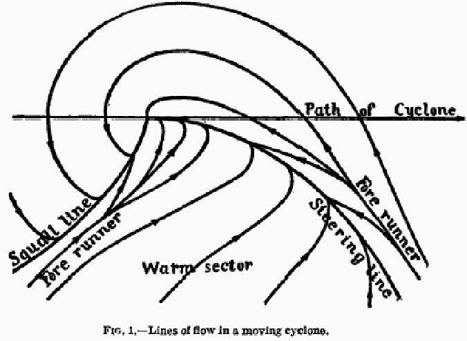 Model of the Structure of Moving Cyclones. |
|||||||||||||||||||||||||||||||||||||||||||||||||||||||||||||||||||||||||||||||||||||||||||||||||||||||||||||||||||||||||||||||||||||||||||||
 |
 |
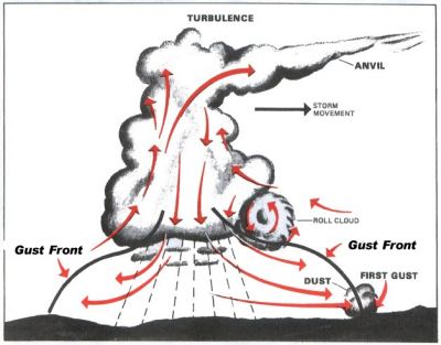
Thunderstorm Gust Front |
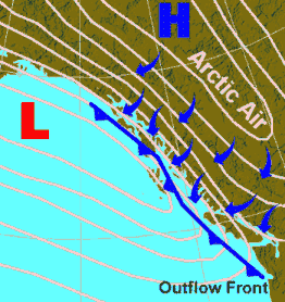
Arctic Outflow Front |
An outflow front is the leading edge of a region of cold air coming out of high terrain, often moving out over a body of water. These are common in winter along the Canadian Pacific Coast when cold air from the interior of British Columbia pushes through mountain passes down over the coastal waters. A similar type of front may be found at the head of a downslope or down-valley wind when cold air descends a slope or down valley from higher elevations a part of a diurnal heating and cooling cycle.
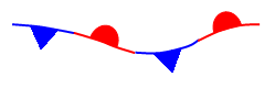 I’ll begin the discussion of the four main fronts with the stationary front since in the Bergen model, the stationary front is at the initiation of the cyclone wave development. On a weather map, the stationary front is depicted with alternating triangular barbs and semicircles. On colored maps, the barbs are blue and the semicircles, red.
At a stationary front, in essence, the two air masses are at a standstill with neither moving perpendicular to the frontal boundary. In an idealized world, a stationary front should separate all distinct and adjacent air masses when they themselves are stationary. In the ideal, the polar front would be a stationary front separating polar air from tropical air somewhere in the mid-latitudes. Usually when a stationary front is present, neither air mass is strong enough to push the other aside. As a result, a plot of surface isotherms (line connecting points of equal temperature) shows isotherms that are broadly spaced. Above a stationary front, the upper level winds, which push and steer air masses, blow parallel to the frontal boundary.
[It should be noted here that in the real world, the front is not an absolute dimensionless line but more of a zone of transition, which can be quite amorphous in its environmental properties. This zone can be very narrow, particularly at fast moving fronts when it passes quickly enough to seem like a sharp and often turbulent boundary. In other cases, such as the stationary front, it might be hundreds of metres wide. Also note that the discussion is based on weather in the Northern Hemisphere.]
In some instances, segments along the frontal boundary in a wave cyclone or family of cyclones cease moving, or move extremely slow (usually at a speed less than about five knots), and these are indicated on weather maps as stationary fronts. Such stationary fronts may dissipate after several days or be reactivated as warm or cold fronts if conditions aloft change and the air masses again begin moving. When a front is stationary for any length of time, the density (usually temperature) differences degenerate with time and may be recognizable only as a shear line — a narrow zone with distinct wind direction changes.
Weather conditions along a stationary front can be quite variable initially, but when the front remains stationary for some time, the weather becomes more like that of a warm front with persistent stratiform clouds and prolonged precipitation.
 In simplest terms, a warm front characterizes the zone where warmer air replaces colder air, though, as we will see later, a warm occluded front also exhibits this characteristic. In the ideal cyclone model, the warm front precedes the low-pressure center and moves from the southwest to the northeast. Typically, the speed of advance of a warm front is 10–20 km/h (6-12 mph). At the frontal boundary, the less dense warm air begins to ascend the colder air it is overtaking. The warm front is denoted on a weather map by (red) semicircles that sit on the side of the line pointing in the direction of motion.
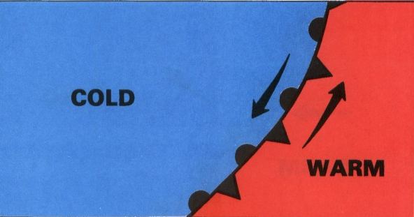
If we look at a cross-section view of a warm front, the most noticeable feature is the gentle slope (roughly 1:200 to 1: 300, that is, a one-kilometre rise at a distance out of 200 or 300 km) to the front as the warm air glides over the colder air ahead. As the warm, and usually moist, air rises, it cools, forming clouds well ahead of the front. Often, a thin layer of cirrus can be observed as far ahead of the warm front as 1000 km (625 miles). The textbook sequence of clouds ahead of the warm front is cirrus, followed by cirrostratus, altostratus, nimbostratus and stratocumulus clouds. In some circumstances, cumulo-clouds, including cumulonimbus, can be embedded in the advancing cloud deck. The actual cloud sequence may vary from the idea, of course, depending on the environmental conditions surrounding the warm front.
Because the frontal boundary aloft slopes gently upward ahead of the surface warm front, upward air movement associated with warm fronts are typically not as strong as the vigorous upward motions associated with a cold front, and thus clouds tend to be more horizontal (stratoform) in structure, and the accompanying precipitation widespread and light to moderate in intensity. But this is not always the case as thunderstorms can develop along the warm front.
At the front itself, precipitation can be steady and frontal fog is often present in the nearly saturated air. With the front’s passage, the weather typically becomes warmer and more humid. On a weather map, a plot of isotherms generally shows a bunching of the isolines over a short distance, which is an indicator that a front is located somewhere in the vicinity. The wind direction at the front shifts abruptly, usually from the east (east northeast through east-southeast) to the south (south to southwest). The shift in wind direction is another indicator of a warm front’s position and can be useful in locating the front on those occasions when the temperature contrast across the front is small. Changes in relative humidity or the dewpoint temperature may also be used to determine the passage or location of a warm front.
The following chart shows the typical weather characteristics associated with a warm front from its approach to passage.
| Weather phenomenon | Prior to the Passing of the Front | While the Front is Passing | After the Passing of the Front |
|---|---|---|---|
| Temperature | Cool | Warming suddenly | Warmer, then leveling off |
| Atmospheric pressure | Decreasing steadily | Leveling off | Slight rise followed by a decrease |
| Winds | South to southeast (Backing) | Variable | South to southwest (Veering) |
| Precipitation/conditions | Showers, snow, sleet, or drizzle | Light drizzle | Usually none, sometimes light rain or showers |
| Clouds | cirrus, cirrostratus, altostratus, nimbostratus, then stratus and fog; occasionally cumulonimbus in summer | Stratus, sometimes cumulonimbus | Clearing with scattered stratus, sometimes scattered cumulonimbus |
| Visibility | Poor | Poor, but improving | Fair in haze |
| Dew Point | Steady rise | Steady | Rise, then steady |
(from Wikipedia, 2009 http://en.wikipedia.org/wiki/Warm_front)
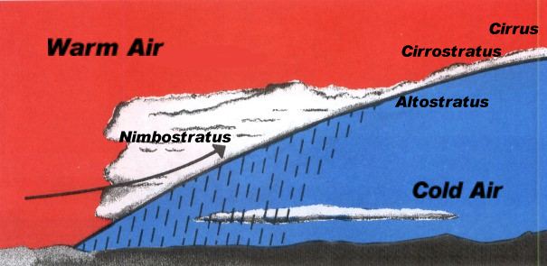
 In the usual sequence of wave cyclone passage, the cold front follows the warm front. On the weather map, red triangular barbs mark the cold front’s position and point in the direction of the cold air’s motion. As with the warm front, we can define the cold front in simple terms as the zone where cold air replaces warm air (with a similar nod to the cold occlusion). Not only is the temperature change of the air opposite from that of the warm front, the humidity level also drops behind the cold front. And unlike the warm front where the warmer air glides over the colder air ahead of it for many hundreds of kilometres, the cold front quickly undercuts the warm air ahead, pushing it to higher altitudes. Thus, the cold front has a very steep slope (1:50), four times or more that of a warm front. Cold fronts also advance at a much higher rate than warm fronts, typically 30–40 km/h (18-25 mph).
Because the cold air at the leading edge of a cold front is undercutting the warm air, it causes the warm, usually moist, air to rise, often rapidly, forming convective clouds types, i.e. the cumulus family. Thus, precipitation associated with cold fronts is often heavy but short-lived and falls over a short distance around the front, typically in a band 50-70 km (30-110 miles) wide. It is not uncommon for cold frontals precipitation to be quite stormy, however, with thunderstorms that are capable of producing locally heavy rains, hail, and even tornadoes.
Even when cold frontal passage is dry, it can be accompanied by gusty, and strong winds that usher in the colder air, which may have temperature drops in excess of 15 C degrees (27 F degrees) within the first hour. The temperature drops at a cold front are usually greatest during the winter, spring and later autumn, but may be small during the late spring, summer or early autumn. In these months, the sensible difference in the air between the two sides of the cold front is most often felt as a decrease in humidity, and thus, calling such fronts, dry fronts might be more appropriate.
Most often, when a cold front approaches, it is coming from the north, northwest or west at the leading edge of a polar air mass. Winds therefore shift from a southerly (S-SW) direction to one from the NW quadrant (W-N). There are occasionally exceptions to this sequence in North America, particularly on the US northeast coast. In certain situations, the cold air approaches from the NE quadrant (N-E), and the cold front is termed a backdoor cold front. Backdoor cold fronts in New England are often associated with Nor’easters when there is a cold air mass over the Canadian Maritimes.
The following chart shows the typical weather characteristics associated with a cold front from approach to passage.
| Weather phenomenon | Prior to the Passing of the Front |
While the Front is Passing |
After the Passing of the Front |
|---|---|---|---|
| Temperature | Warm | Cooling suddenly | Steadily cooling |
| Atmospheric pressure | Decreasing steadily | Lowest, then sudden increase | Increasing steadily |
| Winds | Southwest to southeast | Gusty; shifting | North to west (usually northwest) |
| Precipitation/conditions* | Brief showers | Thunderstorms, sometimes severe | Showers, followed by clearing |
| Clouds* | Increasing: Cirrus, cirrostratus, and cumulonimbus | Cumulonimbus | Cumulus |
| Visibility* | Fair to poor in haze | Poor, but improving | Good, except in showers |
| Dew Point | High; steady | Sudden drop | Falling |
(from Wikipedia, 2009 http://en.wikipedia.org/wiki/Cold_front)
Because cold fronts move faster than warm fronts, eventually the colder air behind a cyclone will overtake not only the warm air sector ahead of it but also the cold air ahead of that warm front. This usually happens in the late mature stage of a wave cyclone’s lifetime and usually signals the beginning of the end of that cyclone’s lifetime by cutting off the supply of warm moist air. When the warm air is lifted off the surface, a new type of front is formed, known as the occluded front. The occluded front is thus the boundary that separates the cold air mass to the west of the low pressure center from the cold air mass that is ahead of the both the low and the warm front. In the process of occluding, the western cold air undercuts both the warm air to the east and causes it to rise above the surface.
 In the past, weather analysts designated the occluded front on a weather map as a line with both red semicircles and blue barbs on the same side and facing in the direction of the movement of the colder air. This has changed in recent years to purple as the designated color to the line and symbols.
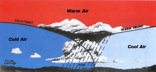
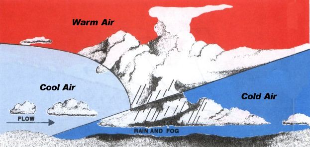
There are two types of occlusion: the warm occlusion and the cold occlusion. The difference depends on the relative temperatures of the cold air masses behind and before the warm air sector. In the cold occlusion, the western air mass overtaking the warm front is colder than the cold air ahead of the warm front, and therefore undercuts both air masses and lifts them. For the warm occlusion, the western air mass overtaking the warm front is not as cold as the cold air ahead of the warm front, and thus while it lifts the warm air above it, they both override the eastern cold air mass. In both types of occlusions, there are well-defined vertical boundaries between the coldest air, the cool air, and the warm air.
The two diagrams below illustrate the differences between the cold (left) and warm (right) occlusions.
 |
 |
The weather along an occluded front can be quite varied, but usually their passage is associated by a reduction in humidity and a noticeable wind shift from the east-southeast to the west-southwest behind the front. With cold occluded fronts, the weather initially is similar to that at a warm front, but it eventually changes into the typical cold frontal weather. With warm occluded fronts the weather is similar to typical warm frontal weather and remains so.
The following chart shows the typical weather characteristics associated with an occluded front from approach to passage.
| Weather phenomenon | Prior to the Passing of the Front | While the Front is Passing | After the Passing of the Front |
|||
|---|---|---|---|---|---|---|
| Temperature
Cold Type Warm Type |
cold-cool cold |
dropping rising |
colder milder |
|||
| Winds | southeast-south | variable | west to northwest | |||
| Atmospheric pressure | usually falling | low point | usually rising | |||
| Precipitation/conditions | light, moderate or heavy precipitation | light, moderate or heavy continuous precipitation or showers | light-to-moderate precipitation followed by general clearing | |||
| Clouds | in order: Ci, Cs, As, Ns | Ns, sometimes Tcu and Cb | Ns, As or scattered Cu | |||
| Visibility | poor in precipitation | poor in precipitation | improving | |||
| Dew Point | steady | usually slight drop, especially if cold-occluded | slight drop, although may rise a bit if warm-occluded |
Table adapted from: Ahrens, (1994) Source http://ww2010.atmos.uiuc.edu/%28Gh%29/guides/mtr/af/frnts/ofdef.rxml
As the basic definition of a weather front given above states, a front separates two air masses of different densities. While most often temperature is the primary factor in defining the differences in the air mass densities, the water vapor content of the air mass can also produced distinctly different air masses, since the density of humid air is lower than that of dry air. In the summer, there are often small temperature differences between air masses that move across the North American continent. This is particularly true in the United States where summer continental polar air masses are usually not very cold and are warmed further as they move southward from the Canadian north. In addition, during the summer months, continental tropical air masses form over the desert regions of the US Southwest and northern Mexico. These air masses are warm and dry.
 Because of the modification of continental polar air masses and formation of continental tropical ones, the temperature differences between them and maritime tropical air masses that move up from the Gulf of Mexico may be small. However, there is a significant difference in the moisture content between them. Thus, the boundary zone between such air masses can best be located by a sharp change in the absolute humidity level, or the dew point temperature, which is the measure of moisture content reported on weather maps and coded station reports. The front that may develop between the summer continental air masses and the maritime air masses under such conditions has been termed the dew point front or the dry line. On a weather map, the dry line is depicted as brown lines with semicircles tightly bunched along the side of the line indicating direction of motion.
Dew point fronts may occur anywhere on Earth in regions where desert areas are near warm seas. In the United States, the southern plains west of the Mississippi River, particularly in New Mexico and Texas, are a favored location.
Because a drier air mass is denser than moist air mass at the same temperature, it will lift the moist air ahead of it when the two meet. The lifting will produce cumuliform clouds and may trigger the development of thunderstorms along and ahead of the dew point front. However, if the dry air is much hotter than the moist air, the dry air mass will be lifted, forming a dry layer at altitude. Dry air above warm, moist air is very unstable and can be explosively so, particularly if a cold air mass is also involved — a condition often found in late spring to the west of the US’s Tornado Alley. Under such conditions, severe thunderstorms with tornadoes can form in the vicinity of the meeting line of a cold front and a dew point front aloft.
Dew point fronts are not usually associated with a wave cyclone system. Therefore, they may not move continuous eastward as other fronts do, remaining over an area for an extended time as a marker of the separation zone between the hot, dry and warm, moist airs. In such a quasi-stationary state, they normally drift eastward during the day and westward at night. At times, however, a strong storm system can sweep a dew point front eastward into the Mississippi Valley or further east. When a dew point front passes, the weather conditions show a sharp drop in the dew point, and a wind shift from south or southeasterly to west or southwesterly accompanied by clearing skies.
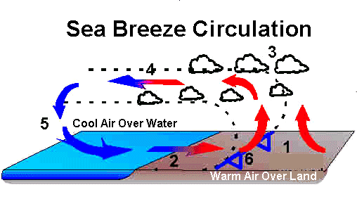
The above discussion of fronts has focused on the larger, synoptic scale fronts commonly displayed on a standard synoptic weather map. Several weather phenomena on the mesoscale, however, exhibit similar patterns to those larger fronts and fit the basic definition of a weather front. I could break these down into two main groups: the mesoscale cold front and the mesoscale warm front, and perhaps add a mesoscale dewpoint front, each with similar significant changes in temperature or moisture content. But rather than describe all of these, I will discuss one of the most common —the sea breeze front — as an example of these mesoscale fronts.
When the temperature over land increases significantly over that of an adjacent water surface, the temperature difference can produce a pressure gradient that can induce breezes to blow off the water onto the land. (For a more complete explanation, see my article: Sea and Land Breezes) As the air moves inland, it does so along an interface that divides the region into two distinct zones. Since the air over the sea (or a large lake) is colder than the air over the land, the boundary between these two zones has similarities to a cold front: a drop in temperature and major change in wind direction from an offshore flow to an onshore flow. One differential between the sea breeze front and a cold front is that humidity usually increases.
 |
|
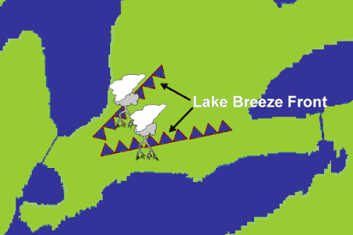
As the sea breeze regime strengthens, this boundary zone, the sea breeze front, moves further inland, undercutting the warmer land air and lifting it. Cumulus clouds may form along the upper regions of this frontal wedge because of this uplifting, and on occasion, thundershowers and thunderstorms may develop. In some areas, such as the Florida Peninsula, thunderstorms are common along the edge of the sea breeze front and can be severe if the sea breeze front from the Atlantic shore meets the one from the Gulf of Mexico to produce a strong convergence zone. A similar situation can be found on large lakes such as the Great Lakes. As in the Florida situation, severe weather can occur in southwestern Ontario when lake breezes from Lakes Erie and Huron meet.
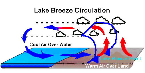
The diagrams below shows the cross section of a lake breeze situation and the convergence of the fronts over Southern Ontario.
 |
 |
Cross section oflake breeze regime |
Convergence of lake breezes over SW Ontario |
At night when the land cools to a temperature lower than that over the adjacent waters, the situation described above may reverse into a land breeze situation, and a land breeze front delineates the boundary between these two mesoscale air masses as the land air flows offshore. In most areas, the land breeze is much weaker than the sea breeze and therefore so is the mesofront.
As meteorologists analyzed frontal weather situations in the years following the Bergen wave cyclone model, they found more detail in the formation of fronts and movement of air masses along a common boundary. Next month, I will look into the more recent developments surrounding fronts.
 |
To Purchase Notecard, |
Now Available! Order Today! | |
 |
 |
Now |
The BC Weather Book: |


