| Home | Welcome | What's New | Site Map | Glossary | Weather Doctor Amazon Store | Book Store | Accolades | Email Us |
 | |||||||||||
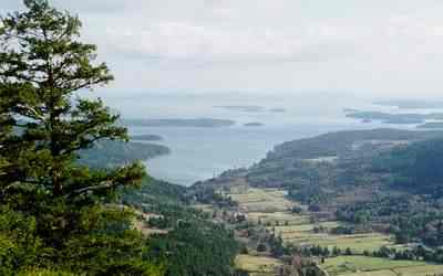
Weather Almanac for April 2002UP, UP AND AWAYDuring the late 1960s, the rock music group The Fifth Dimension produced a hit recording titled "Up, Up, and Away." For those that are unfamiliar with the song, it dealt with riding in a balloon and floating among the stars over a peaceful Earth below. Since then, I have often considered it one of my theme songs as I sat watching the weather unfold around me. Today, as I write this piece, I can see a flock of small cumuli gathering like sheep over the Gulf Islands and the Coast Range on the continent to the east, moving "up, up and away" from me, riding the winds eastward The scene further engendered memories of sitting on a hillside one long-ago April watching cumuli spring up over the flat terrain of Michigan. What I was supposed to be doing that Spring day was studying for my meteorology finals. What I was doing was studying the weather, field research of the best kind, watching cumuli puff into bubbly towers. In both events, I was watching the visible manifestations of updrafts, rising currents of air. The Michigan updrafts were formed solely by the daytime heating of the ground, but for the situation here on Vancouver Island, terrain effects were also hard at work. A general definition for updraft is "a rising current of air," although the term is often limited to upward moving currents within large cumulus clouds and thunderstorms. Storm updrafts are the athletic big brothers of the updraft family, reaching speeds as swift as 80 km/h (50 mph). Most of the family, in contrast, are wee folk, upward currents that rarely exceed 10 cm/sec (0.3 ft/sec) or 0.4 km/h (0.2 mph). 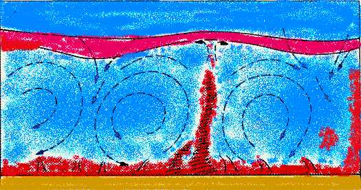 Updrafts (in red) rise as ground surface is heated by the sun above ambient air temperatures (blue). We can identify at least five main driving forces for updraft formation in the atmosphere.
Depending on the time and space scales of interest to the observer, these forces may work alone or in concert, and in some cases, one type may initiate another. I will only briefly describe each here. A companion piece What Goes Up offers more detail. Turbulence is the chaotic twists and turns, ups and downs, working on a very small scale in a fluid flow such as the wind. Turbulent flow is the opposite of smooth (laminar) flow. Topographical forcing is the disrupting effect on airflow from those variations from very flat terrain that would be seen on a topographical relief map: e.g., hills and valleys; mountains and basins; canyons and shorelines. Vegetation and human structures can also produce smaller-scale topographical forcing. Air density forcing, also called buoyancy, produces updrafts due to the density difference between a lighter air parcel and its environment. Most often, the density difference is due to the temperature differential between the parcel and surroundings. Warmer air is lighter air, and it will rise through cooler air. Water vapour content of an air parcel also affects its density. All other factors being the same, a volume of air with greater water vapour content will be lighter than a similar, drier volume and thus rise. Convergence is the process whereby fluid streams move together into a smaller area. In the lower atmosphere, if winds converge at the surface over a relatively small area (surface convergence), the inward push of the air-molecule crowd forces those in the central area to form an upward air current, an updraft. Divergence is the opposite flow situation to convergence -- fluid streams flowing apart from a common area. High in the atmosphere, where the physical barrier of the solid surface is too far below to be effective, a region of upper-level divergence can establish an updraft below it as air is drawn up to replace that leaving the divergence zone. A sixth mechanism is so commonly discussed in most weather books, that I need to at least mention it here. The lifting of air along warm and cold frontal zones forms updrafts through the combination of convergence and buoyancy forcing (at times enhanced by divergence aloft). I consider this a second-rank forcing because it combines two of the main driving forces. Watching UpdraftsAs my regular readers likely realize, I am most interested in weather phenomena occurring on time and space scales that we can personally sense: the small end of the regional scale, the mesoscale and the microscale. Both updraft forcing by topography and by buoyancy often reveal visible signs of updrafts on these scales that the astute observer can recognize once familiar with them. Because I am surrounded by rugged mountainous terrain rising from sea level on Vancouver Island, I see topographical influences on updrafts more often than if I were a resident of flat terrain areas such as Saskatchewan, Kansas or Florida where buoyancy influences are the most dominant. Mountains or high hills are good places to start watching for updrafts, and therefore, I focus the remainder of this essay on watching these topographical updrafts.
Clouds are the best visible indicators of updrafts formed by terrain. Such orographic (terrain-produced) clouds form when moist air, ascending to cross a terrain barrier reaches its condensation level. Above this level, some of its water vapour will condense into liquid droplets and thus form visible clouds.
To the casual observer, these clouds may appear to remain fixed over the summit even when a strong wind is blowing. Concentrated viewing or time-lapse cinematography, however, will show cap clouds to be fluctuating masses, changing their shape and size from one instant to the next. What is actually seen is a train of individual air parcels rising on the windward side above their condensation level, then again dropping below the condensation level on the leeside of the summit ridge. Once below the condensation level, the liquid cloud droplets evaporate into invisible vapour, the clouds rapidly dissipate, and the air clears. 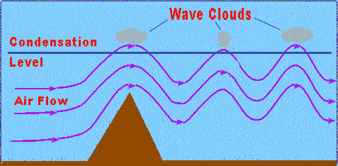 An interesting variation on summit banner clouds occurs when the terrain obstacle induces a vertical oscillation, or standing wave, in the crossing airstream, which persists for some distance downwind. The standing wave pattern that develops causes the air parcels streaming downwind to oscillate above, then below their condensation level. The wave motion forms stationary bands of thin cumulus-type clouds separated by clear air bands extending downwind from the ridge. These cloud bands are called wave clouds. Often, air flow over mountainous terrain produces strong updrafts that lift the air sufficiently to allow the clouds to grow into precipitating cumulus towers or thundering cumulonimbus. The added uplift provided by coastal mountains produces significant rain/snow falls, or enhances that from passing storm systems such as those that strike the Pacific Northwest from southeastern Alaska, through British Columbia, and into Washington and Oregon. The additional contribution of orographic precipitation provides ideal moisture conditions for the trees and vegetation that make up the region's great temperate rainforests to flourish. While clouds provide long-lasting, large indicators of topographically induced updrafts, some animals and plants can also make updrafts visible. The swaying of trees or the flight of their lost leaves can reveal vertical currents. Seed dispersal from species such as milkweed and dandelion and pollens of other plant species can also mark the presence of updrafts if released in great quantities, but usually their small size and low density make following their windblown travels difficult except on the smallest scales. Small animals, particularly spiders, mites, and insects, hitch rides on the wind to extend their dispersal by using updrafts to launch themselves into the airstream. But, they too require close inspection to see. (For more, see the article: Aeroplankton: Living On the Air.)
My most memorable "bird event" was of a soaring bald eagle exploiting the local terrain updrafts. It occurred as I stood atop Salt Spring Island's 589 m (1932 ft) Mount Maxwell. There I witnessed, from a middle point in its ascent path, the eagle ride the updrafts. As I looked down toward the harbour, my eye caught a moving speck far below, the eagle. As it approached the mountain slope, the eagle located a rising current and began its spiral ascent. Circling within the current's stream, it rose to my eye level in a manner of minutes. Continuing past my vantage point, the bird continued ever upward until it was again but a speck in the sky above. During the ten minutes or so that it took to climb from a speck below to one above, the great wings barely flapped, only dipping and twisting as the eagle searched for the best position to ride the updraft. Finally, having reached its desired altitude, the eagle flapped its great wings and disappeared northward.
Today, however, I watch gulls and other sea birds use the topographically induced updrafts along the shore of the Gulf Islands to gain a higher perspective on the sea field below. They can also exploit the air currents above the ocean waves to glide nearly effortlessly for long distances just above the water surface. They catch the small updrafts on the windward wave face that catapult them to a higher altitude. Gliding slowly downward under the pull of gravity, they seek another vertical push just before reaching the wave surface. Smoke from industrial operations or surface fires may also reveal topographic updrafts, but care should be taken in interpretation as the heat which produces the smoke imparts added buoyancy to the smoky parcel, and thus the rise is often due to a combination of buoyant and topographical forces. I could go on for pages on other indications of updraft presence, but I will leave you to explore them on your own for now. I finish, therefore, with a small-scale viewing delight, particularly if you share it with your kids. (If you have none to awaken the child within you, go borrow a few from family or friends for a couple hours.) Small-scale updrafts, as well as the other twists and turns in the wind field around us, can be seen around buildings, trees, fences, hedges, etc. using a simple tracer: soap bubbles. (You could also use feathers or seed fluffs such as dandelions, but that may cause neighbours to anger.) [If perchance you think this is too childish an undertaking, see Duncan Blanchard's account of two renown atmospheric scientists chasing bubbles to study air currents around a building in the name of research.] First, choose a day with comfortable temperature and light to slightly moderate winds. Too light a wind and you will see mostly buoyancy derived currents (not a bad thing, see below). Too strong and the bubbles will disappear too quickly. Next, get some equipment. There are many varieties of bubble makers available on the market, the choice is yours, but a bowl of dish soap solution and a small frame bent from a paperclip or short length of wire is all that is needed. I think the best bubbles for watching the wind are about the size of a dollar coin. Bigger ones are usually too fragile; smaller ones disappear from view too quickly. Finally, start bubbling! Oops, did you remember to round up the kids to play with you? I find setting off a few bubbles at a time allows me to pick one and focus on that bubble's trajectory. However, setting off a small bubble armada can bring out details of the wind's spatial variability. With the aid of the kids, you can launch bubbles from various locations and see how the currents vary over the area. And while you are playing/experimenting, don't forget to give an explanation or two to your bubble crew, even if it is only to get them involved. "Did you see the way that bubble rose and twisted....?" A similar play experiment, on a day when the wind is calm or nearly so and solar heating is strong, can reveal details of local buoyancy-driven updrafts. Another good tool for teaching/learning that gets you outdoors. I could add many pages on watching buoyancy updrafts, but since I have written other essays on this site which mentioned those conditions, I will link some of the URLs here and get back to my weather watching. You too! Push away from the computer and go out and look for some signs of topographical influences on wind flow. This site will stay here for some time to come. Winds of the DayA Springtime Cloud-watching Kind of a Day"Up, up and away in my beautiful balloon....!" Learn More From These Relevant Books
|
|||||||||||
 |
To Purchase Notecard, |
Now Available! Order Today! | |
 |
 |
NEW! Now |
The BC Weather Book: |


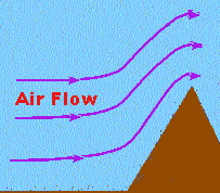 Where topography presents a mostly impenetrable barrier to the airflow, it forces the air to rise over the obstacle, producing updrafts of various strengths. However, any vertical step-up formed by a topographical element, even one as small as a tree or bush, can induce updrafts unless other atmospheric conditions work in opposition, or the breadth of the obstacle (like a telephone pole) makes flow around easier than flow over. All else being equal, the sharper the vertical change in terrain height presented to the flow, the faster the updraft produced by it.
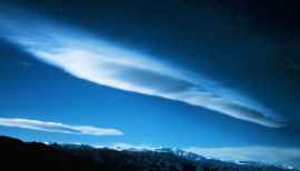 Clouds that form a cap or band across the summit region or extending outward from the summit region are called cap or banner clouds. They are members of the
 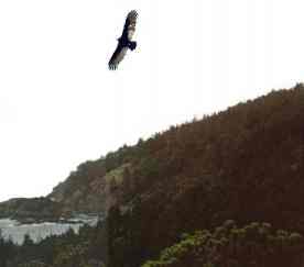 For my money, the champions at exploiting updrafts are members of the bird family. Among the most expert species are the great soaring birds: eagles, hawks and vultures. A few years back, I wrote a piece (