| Home | Welcome | What's New | Site Map | Glossary | Weather Doctor Amazon Store | Book Store | Accolades | Email Us |
|
|
 | ||||||||
Weather JournalA Matter of ScaleIf an extraterrestrial spacecraft approached Planet Earth on a mission of exploration, likely the first feature it would notice would be the ever changing swirl of clouds across the face of this blue planet. From outer space we can easily see interconnected weather patterns moving on a global scale. For meteorologists, this is the largest scale on which weather occurs, but it is not the only one. There is a general agreement on at least four spatial scales of atmospheric phenomena: global, synoptic, mesoscale and microscale. (We could also define several time scales for weather elements.) The global and synoptic scales are often referred to in combination as the macroscale, the largest of scales. Each of these weather scales influences the others and is in turn influenced by them. Often weather on the particular scale is influence by a nearby topographical feature of the same size. For example, mesoscale weather may be influenced by the proximity of a lake containing relatively cold water. The global scale, also known as the planetary scale, consists of the largest weather elements and patterns. Generally, elements thousands of kilometres and greater in dimension are considered global-scale elements. They include the general circulation features, such as the trade winds, prevailing westerlies, Rossby waves and the jet streams, and regions of the atmosphere such as the tropics, the mid-latitudes, the polar regions and the ozone layer. Looking at the weather a little closer than the global scale, we have the synoptic, or continental, scale. This scale covers weather elements such as high and low pressure systems, air masses and frontal boundaries, features commonly found on standard weather maps. The size range of elements found on the synoptic scale are usually from tens to thousands of kilometres in breadth, the area of one continent, and may extend from the surface to the lower stratosphere. 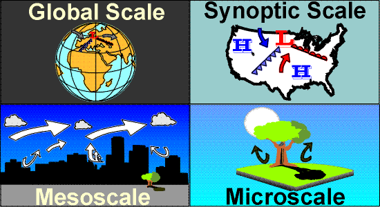 Focus a little closer and we see the mesoscale. This scale, also known as the local scale, covers atmospheric elements from a few kilometres to tens of kilometres in the horizontal dimension and from the surface to the top of the planetary boundary layer, about 1 kilometre in depth. Squall lines and other convective storms fit into the mesoscale as do sea-land breeze regimes, slope winds and a number of other topographically influenced weather features. The mesoscale can be thought of as encompassing an area from the size of towns to that of metropolitan regions. Mesoscale weather is what you see on the weather maps and forecasts for a specific area, or a state or province. Finally, if we look really close, we see the microscale. The microscale includes all atmospheric processes less than a few kilometres in size. This size range can include your backyard or garden, your neighbourhood, or a small lake, hills or wooded area. It can even be seen in differences within your garden or around the outside of your house or school. We don't think too much about the microscale, but it is the one in which we most intimately live and the one we have some ability to modify. Learn More From These Relevant Books
|
|||||||||
 |
To Purchase Notecard, |
Now Available! Order Today! | |
 |
 |
NEW! Now Available in the US! |
The BC Weather Book: |


