| Home | Welcome | What's New | Site Map | Glossary | Weather Doctor Amazon Store | Book Store | Accolades | Email Us |
 | |||||||||||||||||||||
Hail FormationHail is the prime warm season species of frozen precipitation, born of severe thunderstorms. Hailstones when sliced through their center reveal an onion-like layering, particularly evident in the larger stones. These distinctively different layers indicate the type of ice formed as the hailstone grew in size, layers usually alternating between opaque ice and clear ice. An opaque ice layer forms when the hailstone collects small, supercooled liquid water drops that freeze rapidly on impact, thereby trapping air bubbles within the ice and giving it a "milky" texture. When larger supercooled water drops impact on a hailstone, the freezing is slower, allowing the air bubbles to escape, and thus forming clear ice.
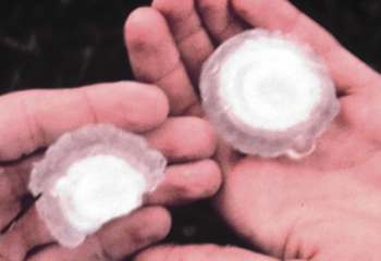
The US National Weather Service recognizes a series of descriptor terms for various hailstone diameters, ranging from pea-sized to softball-sized. The British Meteorological Office uses a slightly different set of terms. (Charts listing these descriptor terms are given here.) The largest hailstone ever documented fell in Coffeyville, Kansas on September 3, 1970, weighing 0.75 kilograms (1.67 pounds), and spanning 14.4 centimetres (5.67 inches).
Hailstone Formation Hailstones generally begin forming on seeds of small frozen raindrops or soft ice particles known as graupelwhich are hardened conglomerates of snow flakes. Graupel or frozen droplets are not the only embryos for hail. Hailstones sometimes contain foreign matter such as pebbles, leaves, twigs, nuts, and insects that have been lofted into the storm cloud by strong updraft winds.
The size of hailstones usually increases with the intensity of the storm cell from which they spawn. To form hailstones the size of golf balls requires over ten billion supercooled droplets be accumulated, and thus they must remain in the storm cloud for at least 5 to 10 minutes. (Compare this to the one million or so droplets needed to form the typical raindrop.) Therefore, large hail (> 5 cm / 2 inches) forms mostly in supercellthunderstorms which have strong updraft winds.
A layer of drier air in the mid levels of the thunderstorm also assists in hail development. Because very moist air retains more heat, hailstones forming in an extremely moist atmosphere don't freeze properly and resemble soggy slush balls (one reason hail is very rare in hurricanes). As these soft stones fall, they either disintegrate, or simply melt well before reaching the ground. Storm research has determined that hail is most likely to form when the height of the wet-bulb zero level falls between 2200 and 2800 metres (approximately 7000 to 9000 ft). The wet-bulb zero level is an adjustment to the altitude at which the melting point of ice (0oC) occurs and takes into account the added cooling effect generated by the evaporation of precipitation into the surrounding air. Precipitation falling through relatively dry air can cool the air further by evaporation of liquid water, thus lowering the height of the wet-bulb zerolevel below the altitude of the 0oC temperature isotherm. It is important that the wet-bulb zero level falls within this narrow altitude range, for the likelihood that a hailstone will form and then fall to the surface decreases when the level is outside this range. If the wet-bulb zero level is too high, most hailstones will melt before reaching the ground. A prime example of these conditions can be found in the State of Florida. Although Florida is a hotbed for thunderstorm activity, thewet-bulb zero level is usually too high and thus hail fall is infrequent -- most forming stones melt before reaching ground. If the wet-bulb zero level is too low -- below 2200 m -- it usually indicates a relatively cold air layer at low altitudes that will inhibit the formation of strong updrafts within the thunderstorm needed to promote the growth of hailstones. 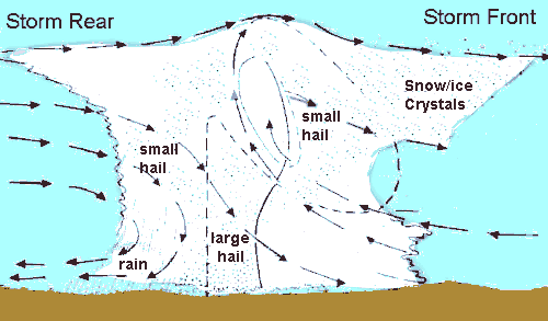 Hail storms require strong updrafts, cold levels and sufficient ice nuclei and supercooled water to form. Thus, the squall line and supercell thunderstorms are the most frequent hail producers. Supercells have the greatest potential for damaging hail since they are physically taller clouds and have access to the colder levels of the atmosphere. They are also longer lived and thus have a better chance of acquiring nuclei in sufficient quantities to form hail. The Role of the Updraft
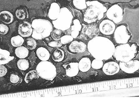
The updraft is not only the agent producing hail, it is also responsible for pushing cumulonimbus cloud tops high into the troposphere, creating the environment for lightning and its sibling thunder, and the various wind characteristics of the thunderstorm cell. [I wrote extensively on the updraft in the April 2002 Almanac. Click here for a portal to those articles.] For the smallest hail to form, an updraft of around 36 to 54 km/h (24-34 mph) is required. Larger stones -- those termed golf-ball size (1 3/4 inch diameter) -- require updrafts of around 88 km/h (55 mph) to form.Softball-size hail involves updrafts exceeding 160 km/h (100 mph). Fifty years ago, the most widely held theory of hailstorm formation envisioned the growing hail riding a roller coaster of thunderstorm updrafts and downdrafts before falling earthward when their weight finally exceeded the updrafts' lifting capabilities. We now believe that this is but one possible mechanism for hail formation. Hail need not ride a Cb elevator but may increase in size by falling slowly through a layer rich in supercooled water. We now believe that this is but one possible mechanism for hail formation. Hail need not ride a Cb elevator but may increase in size by falling slowly through a layer rich in supercooled water. Such hailstones are often characterized by having little layering of the ice within. In the rough and tumble environment of the thunderstorm interior, hailstones of various sizes may collide. While the force of collision may break the stones into smaller ones, it may also weld stones together. Such violent interactions are the source of the irregular, large hailstones often observed. Eventually each hailstone breaks free from its aerie and plunges to earth. Its fall may be the result of an increase to a size unable to be countered by storm cell's updrafts, or it may be caught in a downdraft and hurled earthward. Large hailstones fall at speeds faster than 160 km/h (100 mph). Not all hailstones survive the downward trip, however. Some are broken through collisions into smaller chunks that melt before reaching the surface, others just melt as they traverse the warmer (above freezing) air below the storm. An estimated 40-70% of hailstones formed within a cumulonimbus nursery melt before touching ground. Viewed from the air, we can see that hail falls along paths known as hail swaths. These can be quite small -- a hectare or so (a few acres) in area -- or quite large, 16 kilometres (10 miles) wide by 160 kilometres (100 miles) long. Wide hail swaths usually are associated with squall line thunderstorms. 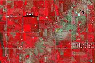 Hail swath (greenish path) from 13 July 1997 hailstorm outside Sioux Falls, South Dakota as seen by Landsat. Credit: US Geological Survey, (Landsat 5 TM, 16 July 1997) Hail swaths can pile hail so deep it must be removed with a snow plow. In Orient, Iowa, for example, in August 1980, "hail drifts" were reported 2 metres (6.5 feet) deep. Large and severe hail swaths may devastate one field of crops while leaving a neighbour's untouched. 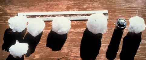 Assorted Hailstones (Credit: NOAA Photo Library) Note Added September 2010: For more on Hail, see the July 2002 Almanac.Photo Credits: NOAA Photo Library, NOAA Central Library; OAR/ERL/National Severe Storms Laboratory (NSSL).For an incredible video of an Oklahome hailstorm, click belowLearn More From These Relevant Books
|
|||||||||||||||||||||
 |
To Purchase Notecard, |
Now Available! Order Today! | |
 |
 |
NEW! Now Available in the US! |
The BC Weather Book: |


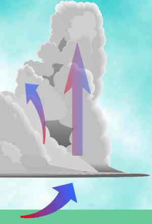 For the hail embryos to grow, they must remain in a layer of supercooled water for a length of
time -- the longer the residency, the larger the hailstone's potential size. And since Mother Earth
has a strong attraction -- gravity -- for all things airborne, there must be a countering force to
keep them aloft. This is supplied by the Storm King in the form of strong updrafts which
construct the great towers of the cumulonimbus (Cb)storm clouds.
For the hail embryos to grow, they must remain in a layer of supercooled water for a length of
time -- the longer the residency, the larger the hailstone's potential size. And since Mother Earth
has a strong attraction -- gravity -- for all things airborne, there must be a countering force to
keep them aloft. This is supplied by the Storm King in the form of strong updrafts which
construct the great towers of the cumulonimbus (Cb)storm clouds.