| Home | Welcome | What's New | Site Map | Glossary | Weather Doctor Amazon Store | Book Store | Accolades | Email Us |
 | |||||||||||||||||||||
Weather Almanac for July 2002HAIL TO THEE
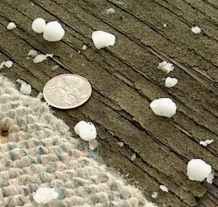
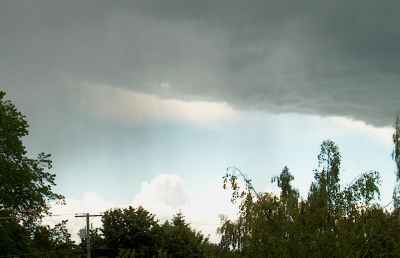
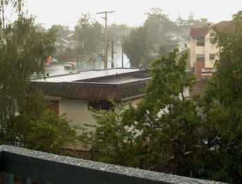
Hail is no stranger to southeastern Vancouver Island, particularly in the elevated regions, but it is more common in the cold months when moist air flows off the warmer Pacific and thrusts upward by the Island's mountains. These hail storms provide us with small, usually pea-sized hail. My home turf is not blessed with many thunder showers or thunderstorms. Often here in Victoria, they are so short that by the time you can react, say "What's that?" and go to the window, it is all over. The storm that struck June 7 had a few rumbles of thunder — thought I saw no lightning myself — but it did treat me to three separate hail showers. The heaviest lasted about tree minutes and produced dime-sized hail. The accompanying photo was taken shortly after the second fall. The larger stones did not land on my protected balcony, but enough of the smaller ones were blown in to cover about 60-70% of it.
HailstonesHail is the prime warm-season species of frozen precipitation, born of severe thunderstorms. Hail stone size usually increases with the intensity of the storm cell from which they spawn. For example, a hailstone the size of a golf ball requires over ten billion supercooled droplets to be accumulated, and thus it must remain in the storm cloud for 5 to 10 minutes and be held aloft by updrafts exceeding 88 km/h (55 mph). When sliced through their center, hailstones reveal an onion-like layering, particularly evident in the larger stones. These distinctive layers alternating between opaque ice and clear ice, indicate the manner in which ice accumulated during different stages of the hailstone's growth. 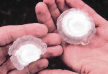 Hailstone layers (Credit: NOAA Photo Library) An opaque ice layer forms when the hailstone collects small, supercooled liquid water drops that freeze rapidly on impact, thereby trapping air bubbles within the ice and giving it a "milky" texture. When larger supercooled water drops impact on a hailstone, the freezing is slower, allowing the air bubbles to escape, and thus forming clear ice. 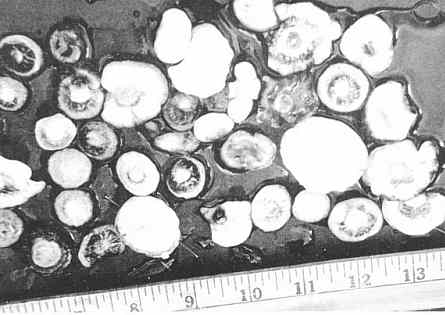 Assorted Hailstones (Credit: NOAA Photo Library) The US National Weather Service recognizes a series of descriptor terms for various hailstone diameters, ranging from pea-sized to softball-sized. The British Meteorological Office uses a slightly different set of terms. (Charts listing these descriptor terms are given here.)
The largest hailstone ever officially documented fell in Coffeyville, Kansas on September 3, 1970. It weighed 0.75 kilograms (1.67 pounds), and spanned 14.4 centimetres (5.67 inches). The previous record stone fell at Potter, Nebraska on July 6, 1928. It measured 13.7 cm (5.4 inches) in diameter and weighed about 0.68 kg (1.5 lb). In the Potter storm, eyewitness accounts reported individual hailstones fell far apart, about 3 to 4.5 metres (10 to 15 ft) from each other. This seems to indicate large areas of hail were swept together to form the large stones. Note Added November 2003: Note Added September 2010: Hailstone record size is not a regularly kept statistic around the world, so reports of supersized hail fall more in the oddity category. Recently while looking for other information, I came across a page in the Bulletin of the American Meteorological Society from 1975 that reported "record-sized hailstones falling in Canada: one in Saskatchewan; the other in Alberta. The Alberta stone fell on the farm of Mr G. Wilson located 8 km southeast of Wetaskiwin on 6 July 1975. It weighed 249 g (0.55 lb) and appears in the photograph to be about 9 cm (3.5 inches) in diameter. The Saskatchewan stone was heavier, weighing in at 290 g (0.64 lb), though it might have been much heavier as "a half inch of ice melted" before it could be put in a freezer. This stone fell on the farm of Mr H. Gawel near the village of Cedoux on 27 August 1973. Though the size is harder to judge in the photograph accompanying the note, I would estimate it too is in the 9-cm range. [Note added 4 April 2007.]
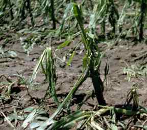
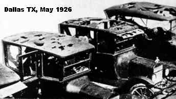
Viewed from the air, we can see that hail falls along paths known as hail swaths. These can be quite small — a hectare or so (a few acres) in area — or quite large, 16 kilometres (10 miles) wide by 160 kilometres (100 miles) long. Hail swaths can pile hail so deep it must be removed with a snow plow. In Orient, Iowa, for example, in August 1980, "hail drifts" were reported 2 metres (6.5 feet) deep. Large and severe hail swaths can devastate one field of crops while leaving a neighbour's untouched. Hailstone Formation in a NutshellHailstones generally begin forming on seeds of small frozen raindrops or soft ice particles known as graupel which are hardened conglomerates of snow flakes. In order for the frozen raindrops or graupel to grow into true hailstones, they must accumulate additional ice by spending time in cloud regions rich in supercooled water, where temperatures are below the 0oC (32oF) level. Since hailstone formation requires strong updrafts, cold air regions and sufficient ice nuclei and supercooled water, squall line thunderstorms and supercell thunderstorms are the most frequent hail producers. Supercells have the greatest potential for damaging hail since they are longer lived and physically taller than most thunderstorms, able to reach to the colder levels of the troposphere. For the hail embryos to grow, they must remain in a layer of supercooled water for some time — the longer the residency, the larger the hailstone's potential size. And since Mother Earth has a strong attraction — gravity — for all things airborne, there must be a countering force to keep them aloft. This is supplied by the Storm King in the form of strong updrafts which construct the great towers of cumulonimbus (Cb) storm clouds. For the smallest hailstone to form, an updraft of at least 36 km/h (24 mph) is required. Larger stones — those termed golf-ball size (1 3/4 inch diameter) — require updrafts of around 88 km/h (55 mph) to form. Softball-size hail involves updrafts of over 160 km/h (100 mph). Fifty years ago, the most widely held theory of hailstorm formation envisioned the growing hail riding a roller coaster of thunderstorm updrafts and downdrafts before falling earthward when their weight finally exceeded the updrafts' lifting capabilities. We now believe that this is but one possible mechanism for hail formation. Hail need not ride a Cb elevator but may increase in size by falling slowly through a layer rich in supercooled water. 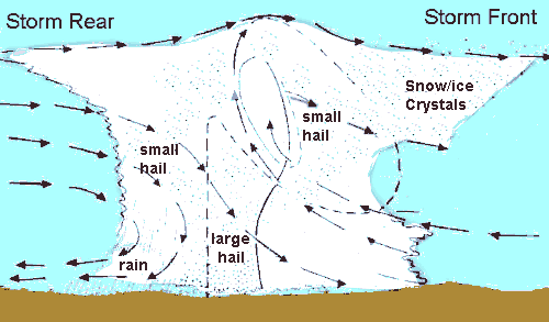 Eventually each hailstone breaks free from its aerie and plunges to earth. Its fall may be the result of an increase to a size unable to be countered by storm cell's updrafts, or it may be caught in a downdraft and hurled earthward. Not all hailstones survive the downward trip, however. Often less than half the hail formed within a cumulonimbus nursery ever touch ground. Some break up into smaller chunks that melt before reaching the surface, others just melt as they traverse the warm air below the storm's freezing level. [For more on hail formation, see Hail Formation on this site.] Hail ClimatologyIn the USA, hailstorms are most common on the Plains, especially just east of the Rockies."Hail Alley" — the most hail-struck region — is found where Colorado, Nebraska, and Wyoming meet, averaging between seven and nine hail days per year within this zone. Hail in this part of the country is most likely to fall late in the afternoon during the months of May and June. Regions in Canada with the most hail-days (number of days on which hail fall is reported) are the central and eastern Prairie Provinces — parts of Alberta, Saskatchewan and Manitoba — south-central British Columbia and southwestern Ontario. The highest annual frequencies in Canada (for the 1977-1993 analysis period) were between 3 and 7 hail days during warm months (May-September). Canada's hailstorm alleys are located in interior British Columbia and in Alberta with 5 to 9 hail-days per season. Hail typically forms most frequently between noon and evening, usually from May to July. Other parts of the world where damaging hailstorms are frequent include China, Russia, India and northern Italy. Hail DamageHailstorms are among the most damaging weather events each year in the US and Canada. Dollar damage totals in the US approach $1 billion annually. Costs are conservatively estimated at $100 million per year in Canada. The most destructive hailstorm in North America occurred around Dallas, Texas during 5 May 1995, caused an estimated damage of $2 billion, and injured 510 people. This storm supplanted a Denver, Colorado hailstorm whose softball-sized hail caused $625 million in property damage, mostly to automobiles and roofs, on 11 July 1990. The most costly Canadian hailstorm occurred on 7 September 1991 in Calgary, Alberta causing an estimated $360 million in insured damage and $450 million in estimated total damage. Much of the damage from hail is inflicted on crops, thus earning hail the title of the white plague in the agriculture industry. Damage to vehicles, buildings — particularly roofs — and landscaping lead the list of damage outside the agricultural sector. (As you can see in the accompanying photo, hail damage to automobiles has been with us for years.)
Hail of any size can also cause injury to humans and animals and has been fatal in the US. The last reported death, an infant, occurred in August 1979 at Fort Collins, Colorado. The most deadly hailstorm on record occurred in India on April 30, 1888, killing 246 people and 1600 domesticated animals. Note Added July 26, 2002: The following news report came from China during the past week (July 11-20). "A deadly hailstorm of giant hailstones, some the size of eggs, killed 25 people and left hospitals overflowing with head-wound victims in central China. The hailstorm struck northern parts of Henan province on Friday evening [July 19], uprooting trees, smashing car windscreens, cutting off electricity and destroying buildings. Locals described it as the worst hailstorm in at least half a century. " Thus It Ends
\ For an incredible video of an Oklahome hailstorm, click belowPhoto Credits: NOAA Photo Library, NOAA Central Library; OAR/ERL/National Severe Storms Laboratory (NSSL), and Keith Heidorn unless noted.Learn More From These Relevant Books
|
|||||||||||||||||||||
 |
To Purchase Notecard, |
Now Available! Order Today! | |
 |
 |
NEW! Now |
The BC Weather Book: |


 Perhaps the weather gods had planned this in advance, or maybe they had just read my mind. But less than a
week before I sat down to write this article, they presented me with an exhibition of hail to remind me, albeit
weakly, of the storm genre.
Perhaps the weather gods had planned this in advance, or maybe they had just read my mind. But less than a
week before I sat down to write this article, they presented me with an exhibition of hail to remind me, albeit
weakly, of the storm genre.