THE GREAT HURRICANE OF 1938 Part 3 THE GREAT NEW ENGLAND HURRICANE
It did not take long for the Long Island Express to cross Long Island and the Long Island Sound that separated it from the New England south coast. In the next few hours of 21 September 1938, the Long Island Express would become The Great New England Hurricane, the most destructive hurricane to hit New England in three centuries of European habitation.
At 2 PM EST, the first hammer strike of the great hurricane was felt along the New England coast and the small islands between it and Long Island. Winds gusted to the threshold of hurricane speeds 74 mph (118 km/h) at Block Island, Fishers Island, Stonington, Connecticut, and along the Rhode Island shoreline. When the hurricane storm surge slammed into the New England shoreline, the seismograph of Fordham University at New York recorded the impact as if it were a major earthquake....which in many respects it was.
Crossing New England
By 4 PM, the storm's central eye had reached the Connecticut coast, slipping between New Haven and Bridgeport, and lay inland with its center east of Waterbury. Its central pressure was measured at 28.11 inches (951.8 mb) at New Haven (3:50 PM) and 28.04 inches (949.4 mb) at Hartford (4:30 PM). While the pressure was lowest in western Connecticut, the strongest winds blew further to the east in the destructive front-right sector of the hurricane. This region of any tropical storm has the most destructive winds because the hurricane's winds, blowing in the direction of the storm's movement, receive an added boost from the storm's overall speed. In the case of the Great New England Hurricane, this likely added an extra 60 mph (96 km/h) at landfall to the storm's effective winds.
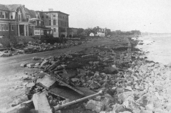
Storm-surge destruction along the eastern Connecticut coast following the 1938 hurricane.
Photo Courtesy Mitchell Field, 2nd Air Base Squadron - U.S. Army, NY, 1938
Fisher's Island, which lay just off the eastern Connecticut coast measured a five-minute average wind speed of 105 mph (168 km/h) at 3:15 PM. There were no further readings; five minutes later, the tower and its wind sensors blew away. Providence, Rhode Island measured a maximum five-minute average wind of 87 mph (139 km/h). Block Island clocked a peak average wind speed of 82 mph (131 km/h). Boston clocked a 73 mph (117 km/h) average wind.
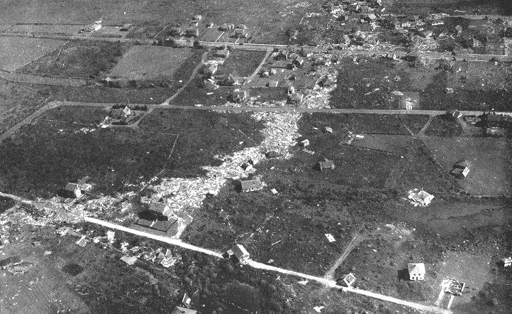
Storm-shocked husband and wife survey the remains of their home and community in the Harbor View district, southeast of New Bedford, Massachusetts Photography by Steve Nicklas, NOS, NGS Photo Courtesy Historic NWS Collection
The highest recorded wind speed came from nearby Blue Hill Observatory in Milton, Massachusetts, though topography affected its winds, clocking a 121 mph (194 km/h) average peak and gusts of 173 mph and 183 mph (277-293 km/h). These wind speeds may be unrepresentative of the storm in general due to the fact that the Blue Hill Observatory sits on a hill that slopes up from the south, the direction of the strongest winds during the hurricane's passage here, and this may have an effect on the resulting wind speeds. Even stronger winds would be registered at elevation at Mount Washington in New Hampshire when the hurricane passed through neighboring Vermont: a 136 mph (218 km/h) average wind speed.
In Providence, the wall of water pushed forward by the storm surge came at high tide. The water height thus was further compounded because the tide was an equinoctial high tide, higher than the usual high tides. The highest water marks along the southern New England coast ranged from 12 to 25 feet (3.7-7.2 m) above mean low water (mlw). At Point Judith, RI, the water rose to 18 feet (5.5 m) above mlw; at Fairhaven, Massachusetts, it was estimated the peak was at 25 ft (7.2 m). Pocasset, Massachusetts in Buzzards Bay the water was 20 ft (6.1 m) above mlw; at Nobska Pint Light Station near Woods Hole, Massachusetts, 15 ft (4.6 m).
The seawall at Narragansett Pier, southern Rhode Island. Photography by Steve Nicklas, NOS, NGS Photo Courtesy Historic NWS Collection
The waters funnelled through Narragansett Bay and flooded the city, located about 35 miles (56 km) inland from the main Atlantic coastline. All along the coast from Connecticut to Massachusetts, the surge wiped buildings and docks off the landscape and even scoured the land of sand and soil. Many houses were later found miles form their original foundations. Most were never found at all.
The rains associated with the Great New England Hurricane compounded the flood situation caused by the days of rain preceding this storm. The rivers in the Connecticut and Merrimac Valleys were already close to flood stage before the addition of the hurricane-associated rains and the combination caused disastrous flooding following the storm. The hurricane dumped an additional 4 to 6 inches (102-152 mm) of rain over the Connecticut River Valley giving a total rainfall for the week of 10 to 17 inches (254-432 mm). The added rain caused rivers to overflow their banks. In Hartford, for example, the Connecticut River rose 33 feet (10 m) above normal.
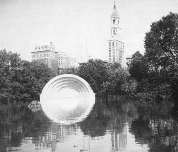
The Music Shell in Bushnell Park in Hartford, Connecticut Photo Courtesy Historic NWS Collection
Moving Inland
At 5 PM EST, the hurricane's center had pushed another 35 miles (56 km) inland and now was located along the western Massachusetts/Connecticut border north of Granby, Connecticut. Though still a powerful storm, its loss of contact with warm waters and the increased friction of the land had begun to weaken the storm. At 5 PM, its central pressure had likely risen to 28.25 inches (956.5 mb), an increase of 0.40 inches (13.5 mb) since its first landfall. At 5:15 PM when the eye region passed over Westfield, Massachusetts, its pressure measured 28.36 inches (960.3 mb).
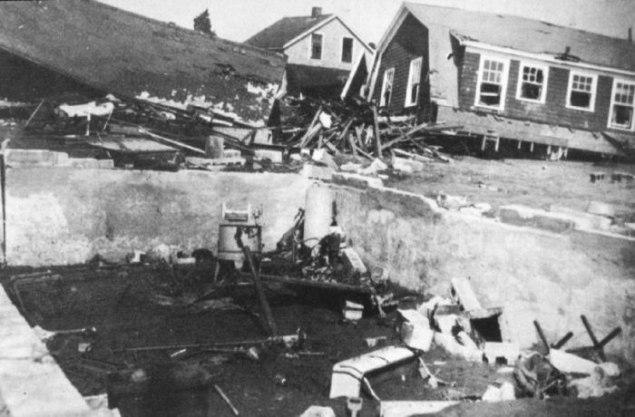
Island Park, Rhode Island was destroyed by a breaker with a reported height of 30 to 40 feet. A sturdy washing machine is all that remains of a destroyed home. Photography by Steve Nicklas, NOS, NGS Photo Courtesy Historic NWS Collection
Though weakening, the tempest still threw gale force winds over the region from Sandy Hook, New Jersey in the south, to Utica, New York to the north, east to Nantucket, Massachusetts and northeast to Concord, New Hampshire. The strongest winds remained in the eastern half of the storm with Putnam, Connecticut and Providence, Rhode Island recording 60 mph (96 km/h) average winds. At Blue Hill Observatory, the anemometer read a one-hour average wind speed of 84 mph (134 km/h) between 5 and 6 PM. A peak wind speed of 186 mph (298 km/h) was estimated with an possible error range of 30-40 mph (50-64 km/h). The high readings at Blue Hill were likely the result of upsloping topographical influences. The observatory sat on elevated terrain that sloped down to the south, the direction from which the storm winds blew.
At 6 PM EST, the storm center had crossed into Vermont and lay near Stratton Mountain, ten miles (16 km) east of Arlington, Vermont, a movement of 65 miles (104 km) in the preceding hour. Here, 100 miles (160 km) from the ocean, it encountered the Berkshire and Green Mountains and the thick forests of New England. A report from Dorset, Vermont indicated that when the center of the storm passed, the winds became calm and the cloud cover broke, suggesting the Great New England Hurricane still had an eye. The central pressure at this time was likely around 28.40 inches (961.6 mb). Gale force winds still blew at Bear Mountain, New York, 40 miles (64 km) north of New York City, and at Block Island. Boston's winds were still at hurricane speed. At Blue Hill Observatory, the peak gust just before 6 PM registered 87 mph (139 km/h). Extreme wind speeds were also measured at the Mt Washington Observatory, located at the summit of Mt Washington. The peak 5-minute wind of 136mph (218 km/h) was taken at an elevation of over 6288 ft (1918 m).
By 7 PM EST, the storm center had reached central Vermont just south of Rutland, but it was slowing. At Northfield, Vermont, the lowest barometer reading occurred at 7:30 PM: 28.77 inches (974.2 mb). At 8 PM, the storm had moved to Burlington, Vermont, a drift to the northwest. Burlington's barometer bottomed out at 28.68 inches (971.1 mb) at 8 PM. Amazingly, the storm still carried hurricane-force winds around its core. A few hours later, the storm center crossed the US�Canada border in the vicinity of Cornwall, Ontario, heading for an eventual death in northeastern Ontario.
One of the interesting aspects of the storm as it rolled up the US coast was its interaction with the low pressure trough over western New England with attendant fronts. The interaction undoubtably ratcheted up the storm's intensity. The analysis of Pierce shows that the hurricane's relationship to the warm and cold air masses was very evident, and thus the storm was possibly a hybrid between tropical and extratropical, or on its way to becoming extratropical as it passed over New England. Perhaps the first "Perfect Storm" occurred in 1938 and not 1991.
Storm Impacts on New England
As previously stated, I do not intend to write a full account of the damage done by the storm across New England. I refer readers wishing to know more to the well written books on the storm: Sudden Sea by R.A. Scotti; A Wind to Shake the World by Everett S. Allen, and The Long Island Express: Tracking the Hurricane of 1938 by Roger K. Brickner.
Western Connecticut was spared much of the fury of the storm's surf and wind, though not its rains. In New Haven, the winds took their toll on the Elm City's favorite tree, leaving splintered and fractured trunks strewn across lawns, cars and homes. Sixty miles east of New Haven and inland from the coast, Norwich suddenly found the water levels rising on the Thames River as the storm's early onslaught halted the river's downstream flow and then pushed its waters upriver on the storm surge.
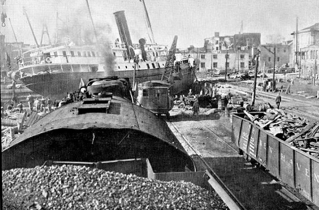
In New London, the first blow of the storm demolished the harbor. Ships ripped from their moorings slammed around the harbor and wrecked wharfs before sinking or beaching themselves. The wind and surf tore the government lighthouse tender Tulip, 190 feet (58 m) long and weighing around a thousand tons, from its moorings and marooned it on the tracks of the New York, New Haven and Hartford railroad tracks behind the Custom House. The tender remained across the tracks for 17 days, proving, according to a report from the railroad, "very difficult to move." Indeed, it took the construction of a new waterway to relaunch it. Salvagers dredged five thousand yards of mud, sand and rock out of a channel 15- 20 feet (4.6-6.1 m) deep in order to refloat the Tulip. Three strong vessels were required to pull the tender back into the water.
The lighthouse tender Tulip lies across the railroad tracks after being pushed ashore by the storm surge. Photo courtesy: E.B. Radovich, I Know A Railroad!
The Tulip was not the only major vessel to be tossed around by the raging seas. Moored in the vicinity of the Custom House by two huge anchors (ten and eight tons), the 300-foot (91.5 m), five masted barkentine Marsala began to be pushed toward the Shaw's Cove railroad bridge. The Marsala, a training ship of the American Nautical Academy, would have been seriously damaged, as well as causing considerable damage to the bridge and other vessels, save for the skill of her master Captain Oliver Bohld, chief officer Commander George Terry and 17 midshipmen. When the wind shifted just before it collided with the railroad bridge, the ship swung around and came up against the Chappell Lumber Company wharf. There, the crew was able to fasten both the bow and stern to the dock, thus preventing the Marsala from causing further damage. In fact, thousands of board feet of lumber were inadvertently trapped between the ship and dock, and thus were prevented from becoming washed out to sea or adding to the dangerous flotsam in the water.
The greatest damage to be inflicted on New London came at 4:30 PM when a short circuit in a flooded building the Humphrey–Cornell Company ignited a fire whose wind-fanned flames would spread across the business district and to random houses miles distant. Every able-bodied man who could be rounded up was pressed into duty to fight the huge fire. Though water was everywhere, power outages reduced the flow in the water mains to a trickle, and thus fire hoses soon ran dry. Nearly a quarter mile (400 m) of the business district burned to the ground. The fire burned out of control for 10 hours, before a shift in wind halted its spread. The fire alone caused an estimated $147 million (2007 dollars) in damage. It was the worst fire in New London since Benedict Arnold burned the town in 1781.
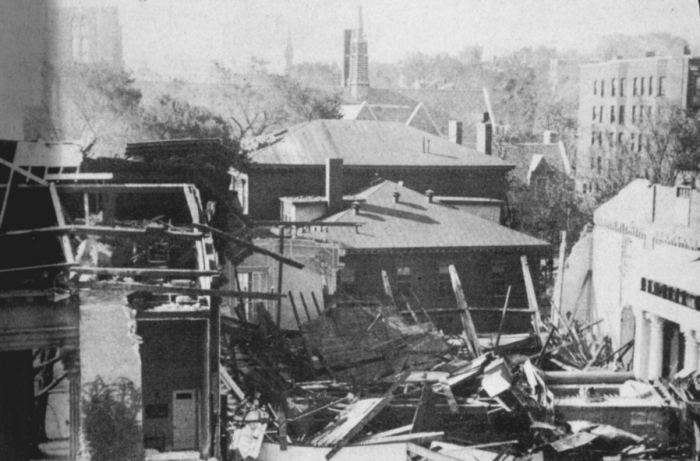
The destruction in Connecticut communities such as Noank, Cornfield Point, Old Saybrook, Old Lyme, Crescent Beach, Clinton, Madison and Westbrook, to name but a few, was appalling. Away from the shoreline, wind and flash floods devastated inland communities, knocking down thousands of trees, plucking off roofs and crashing telephone poles to the ground. Hundreds of churches lost their steeples.
Remains of the steeple of the First Unitarian Church, Worcester, Massachusetts. Photography by Steve Nicklas, NOS, NGS Photo Courtesy Historic NWS Collection
The State Department of Transportation would estimate 50,000 trees had fallen across roads and onto buildings and vehicles. The clean-up of the debris required many weeks, but gave much needed work to local men and women, unemployed during the Depression. The violent winds blew roofs off the dormitories housing 1,200 patients at the state mental hospital in Middletown and the stone tower on the Wesleyan University chapel. The Southern New England Telephone Company reported the storm destroyed more than 5,000 telephone poles and damaged 2,000 others.
At the capitol of Hartford, the storm damaged "The Genius of Connecticut." "The Genius of Connecticut" was a 17-foot (5.2 m) 3.5-ton bronze statue of a woman that capped the Capitol dome since erected in 1878. Though the statue survived the storm in place, it was damaged and posed a risk of toppling from its perch. After much debate, The Genius was removed from the dome and stored in the Capitol basement until 1942. Having survived a hurricane, The Genius became a victim of war when it was melted down to make ammunition and machine parts for the military. (Today, a bronzed version of the statue's original plaster cast stands in the Capitol's north lobby.)
Further east near the Rhode Island border, the crack passenger express of the New York, New Haven and Hartford Railroad, the Bostonian, ran into the teeth of the storm. It was halted just west of the Stonington station due to debris on the tracks, which turned out to be a cabin cruiser and a house. The train had stopped in a precarious spot on a long, low causeway. On one side, the ocean raged under hurricane winds and pounding surf; on the other, the tidal estuary was swollen with churning waters.
The 275 passengers, which included 30 boys heading for a private school in Massachusetts, could only watch the tempest boil around them and await their fate. As they sat in the cars, large houses ripped from their foundations bobbed chaotically in the churning ocean. As the train crew pondered the dilemma, the cars at the rear of the train began to sink into the waters. The pounding waves had begun eroding the railbed. The crew quickly moved most of the passengers forward to the first car behind the heavy locomotive, but others insisted on getting out on the causeway attempting to walk to the station a few hundred yards (metres) away. Brakeman Bill Donoghue managed to uncouple the abandoned cars from the engine and remaining coach car. Slowly the locomotive, tender and single coach car, with many hanging on to the train for their life, moved forward, nudging the boat and house from the track. As it slowly inched forward, the telegraph wires became entangled in the locomotive and were dragged along with several poles to the station. Two, one passenger and one crew member, died in the turbulent waters.
Elsewhere in Stonington, the surge swept shoreline structures off their foundations, some were found two miles (three kilometres) inland. Buildings in the beach towns of Clinton, Westbrook, and Old Saybrook lay in wreckage across coastal roads. In Old Lyme, the powerful storm surge flattened beach cottages or swept them away. Away from the coast, the wind and heavy rains caused the damage and took a multitude of lives. The hurricane center followed the Connecticut River Valley northward, and the rains drove the already swollen river well above flood stage. In Pawtucket, the winds toppled the huge steeples on both the Seventh Day Baptist Church and the Congregational Church within half an hour.
The Great New England Hurricane hit the small state of Rhode Island with the full force of its dangerous front right sector. The storm took between 380 and 433 lives in Rhode Island, over half of the total fatalities attributed to the storm in New England. Much of the damage and death was sustained along the coastline where communities were literally wiped of the face of the Earth.
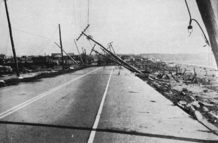
Island Park, Rhode Island was destroyed by a breaker with a reported height of 30 to 40 feet. Archival Photography by Steve Nicklas, NOS, NGS Photo Courtesy Historic NWS Collection
Napatree Point was one such community. Located on a small cape between the Atlantic Ocean and Little Narragansett Bay, southeast of Stonington, Connecticut and southwest of Watch Hill, Rhode Island along the Rhode Island–Connecticut border, it was home to forty two on 21 September 1938: only 27 survived the ordeal. The hurricane drove 44 summer homes from their foundations, smashing many like eggs. The yacht club also disappeared and the point was sectioned into a series of islands. Today, all that remains is a wildlife refuge. A little further east, the rising waters destroyed 500 cottages at Misquamicut.
The Moore family of Napatree Point were one of the lucky families. From their home, they watched their neighbor's home disappear under the onslaught of the surf. One minute Ann Nestor and the maid stood on the front porch, the next they and the building were gone. Then the Moore house, the last house standing on Fort Road, began to shake, and Jeffery Moore yelled to his family to run to the upper floor. Catherine and Jeffrey Moore, their four children — Cathy, Margaret, Geoffrey and Anne — old family friend May Doherty, cook Loretta, maid Nancy, a handyman Andy Pupillo and neighbor Jim Nestor, who had miraculously escaped the demise of his home, huddled in an attic room when the house shook free of its foundations. Suddenly, the floor dropped like an elevator, and they could see the ocean at the bottom of the stairs. Then the wind tore off three of the walls and the roof, and the small group sat with a death-grip on the plumbing pipes now sticking through the flooring.
Incredibly, the remnant of the room launched out into the bay and began "sailing" with the wind and surf. Geoffrey looked down and saw the forms of hammerhead sharks swimming against the flow. Then the group was joined by Cathy's pet parrot. Soon they realized that they had not blown out to sea, but up into Little Narragansett Bay. As night fell, the debris raft beached onto little Barn Island. Clutching their piece of bedroom floor, they had been blown clear across Little Narragansett Bay and deposited safely in Connecticut. Leaving the raft, the party clambered onto the island and sought shelter from the storm in a haystack near a stone wall. The Moore family and their party all survived the ordeal, but both Andy and Jeff would die within the year from causes not directly related to the storm.
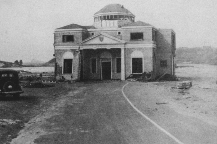
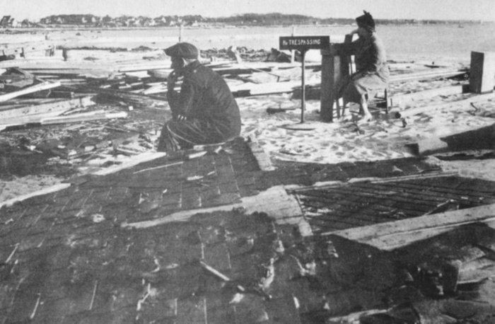
The central portion of the bathing pavilion at Bailey's Beach RI transported to the middle of the
road. Photography by Steve Nicklas, NOS, NGS Photo Courtesy Historic NWS Collection
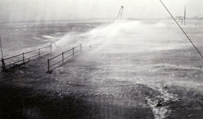
About the only structures on the Rhode Island coast that survived the storm were the large stone mansions at Newport. These survived because they were located high above the surf on the Cliff Walk, though several were damaged by the high winds. On Conanicus Island, the surge battered the Whale Rock lighthouse off its base and into the raging sea, taking lighthouse keeper Walter Eberly to his death. At Point Judith, the winds gusted to 121 mph (194 km/h). On Little Gill Island, near Block Island, the waves rose to 30-35 feet (9.1-10.7 m) above the surge. A later study concluded the highest waters — the combination of surge, tide and wave — and highest sustained winds occurred at Brenton Point southwest of Newport at the entrance to Narragansett Bay.
The shores of Narragansett Bay took the worst hit from the storm surge which destroyed most coastal homes, marinas and yacht clubs. Over 2,600 boats were destroyed, and more than 3,300 damaged. As the storm surge drove into Narragansett Bay, the bay's funnel shape amplified the water's height, rising to a level of nearly 15.8 feet (4.82 m) above normal tides.
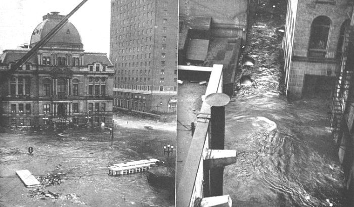
At the bay's northern reaches lies the City of Providence. In downtown Providence, the waters rose to 13 feet, 9 inches (4.0 m), drowning several motorists in their cars and others trying to cross the flash flood to safety. The rise of waters was so swift that thousands were caught in the upper floors of the great commercial district, unable to leave for home. Within half an hour, the water had risen to six feet (1.8 m) in the business district trapping people in buses and cars. Hundreds of vehicles were submerged, and most buildings saw waters rise as high as their second floor. The raging waters tumbled cars, trolley cars and varied debris across the city leaving much of it piled against the high-rise buildings. The debris included houses from nearby Warwick, barrels of heating oil, sofas and chairs, hats and fur coats, and great boulders that had formerly been part of the shoreline. The loss of electrical power compounded the chaos, particularly that night.
Storm surge reaches the downtown Providence, Rhode Island. Waves are visible in front of the Biltmore Hotel (right building), while marooned pedestrians gather on the steps of Providence City Hall. Photo Courtesy Providence Journal 1938
A plaque on the historic Old Market House commemorates the flood water peak, over 2.5 feet (0.76 m) above the previous high water mark set during the Great Gale of 23 September 1815.
Along the shoreline from Quonochontaug to Charlestown, a distance of 7 miles (11.2 km), 99 percent of the property were destroyed. Four hundred cottages at Misquamicut and another two hundred at Charlestown Beach vanished. In Charlestown Pond and Charlestown by the Sea the number of homes lost totalled 100 at each community.
Southern Massachusetts felt the same knockout punch along its coast that Rhode Island did. Buzzards Bay lies about 20 miles (32 km) east of Narragansett Bay. The surge first hit Horseneck Beach, then left Falmouth and New Bedford under eight feet (2.4 m) of water, sinking two-thirds of all the boats in New Bedford harbor. The waves and surge channelled up the bay battering the shore communities including Mattapoisett on its way to the northern bay communities of Onset and Wareham. Only one house remained intact in Westport Harbour. All but a dozen of 107 cottages at Mattapoisett's Crescent Beach were swept away. Properties at Horseneck Beach, Fairhaven and Woods Hole were swept clean.
Heavy surf breaking over SE side of Quadrangular dock at Woods Hole, Massachusetts Photo Courtesy NOAA Photo Library, NOAA Central Library; C&GS Season's Report
Along the eastern shores of Massachusetts, the surf was high but not as destructive as that further south, the full brunt of the storm's force taken by hook of land ending at Cape Cod. Winds were strong, however, with some of the peak velocities measured at Blue Hill west of Boston above hurricane force.
In western Massachusetts, the rain caused the major problem, although the hurricane winds levelled many thousands of trees. Adding hurricane-associated rains (up to six inches/152 mm) to the pre-hurricane rainfalls, the Connecticut River rose to 6 to 10 feet (1.8-3.0 m) above flood stage at Springfield and caused widespread damage. In Ware, the flooding of the Ware and Muddy Rivers stranded residents for days. When the flood waters finally receded, a chasm ran down Main Street, exposing the sewer pipes below.
In the storm's dying hours it would pass over Vermont and impact this state as well as the neighboring states of New York and New Hampshire. Here, great tracts of forest would be levelled by the winds, many of those downed because of the heavy rains had loosened the roots. Blowdown was particularly intense in areas where the terrain funnelled the winds and increased wind speeds. According to an eye witness report by Rudy Arnold: "Acres of trees were scattered about like matchsticks."
In Vermont, gale winds and flooding caused the greatest damage. In New Hampshire, a fire that broke out in Peterborough was fanned by the gale winds and many buildings burned down. The rain-induced flooding swept away ten bridges across the state. Thirteen died in the state as a result of the storm. The storm wreaked havoc across eastern New York State north of the coast. Winds toppled many steel towers, radio masts and telephone/power poles and uprooted trees.
Totalling The Damage
As of the start of the 2008 hurricane season, The Great Hurricane of 1938 ranks sixth in terms of the costliest hurricanes in United States history (adjusted to 2005 dollars) behind the Miami hurricane of 1926, the Galveston hurricanes of 1900 and 1915, Hurricane Katrina and Hurricane Andrew. The total damage from the Great Hurricane of 1938 amounting to $4.5 billion (2007 dollars).
Though the total death toll varies between accounts, the accepted number of hurricane-related fatalities stands at 682. For New England alone, the estimate is 564 deaths, but the accepted number of dead may be low as many bodies were never recovered. More than half the deaths occurred in Rhode Island, in the vicinity of 400 (380 to 433, depending on the source). Ninety died in Connecticut and 88 in Massachusetts. Fifty were lost on Long Island. Maine was the only Northeast State to not record a fatality. As troubling as the death toll was, it is perhaps remarkable that it was so low given the complete devastation of buildings and infrastructure along the coast. Part of that can be attributed to timing, the summer season had just ended, and most people had returned to inland homes and work from their summer homes along the shoreline.
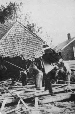
WPA workers and rescue squads search for bodies and survivors at Shawomet Beach, south of
Providence, Rhode Island 22 September1938 Archival Photography by Steve Nicklas, NOS, NGS Photo Courtesy Historic NWS Collection
The hurricane demolished tens of thousands of houses (the figure ranges from 4500 to 57,000) and smashed enough plate-glass windows to cover 17 football fields. Many textile mills, already reeling from the Depression, were severely damaged by the raging rivers that once powered their machinery and never reopened. Twenty thousand miles of electrical lines were toppled. The Bell System employed a repair crew of 2300 to restore phone service to over half a million customers. Their materials list included 400 miles of cable, 31,000 poles, 72 million feet of wire and 50 carloads of telephone hardware.
An estimated 26,000 automobiles were destroyed. Rail service between New York and Boston was interrupted for seven to fourteen days as a crew of 10,000 rail workers filled in track beds, replaced rails, rebuilt nearly 100 bridges and removed thousands of obstructions from the rails including houses and boats.
Damage to the fishing fleets in southern New England was catastrophic. A total of 2,605 vessels was destroyed, with over 3,350 damaged. In addition, the surge scoured oyster beds out to deep water when they perished. Tons of salt spray sent airborne by wind and wave damaged acres of vegetation and crops across New England and was evident as a white film on the windows of homes in Vermont, 120 miles (192 km) from the sea. Crops were flattened in the field, many awaiting harvest, and livestock losses numbered in the tens of thousands. Many farmers were wiped out, losing crops, animals and buildings. Half the apple crop in the region was destroyed at a loss of $29 million (2007 dollars). A third of Vermont's sugar maples were knocked down or severely damaged.
Tree damage in forests and in communities was extensive throughout New York and New England where an estimated 2 billion trees were lost. New Hampshire lost half of its white pines. The white pine forests of Rhode Island were its richest natural resource; in three hours most of them were gone, wiping out the state's forest industry. The US Forest Service estimated that the timber blown down by the storm would require five years of work to salvage and could have provided enough wood to build 200,000 five-room house.
All across New York and New England, towns lost their character-defining trees, many of which had survived since the Revolutionary War. For example, in East Hampton, Long Island, elm and locust trees formed an arch over Main Street a half mile (800 m) long. Most had been planted before the American Revolution and can be seen in the paintings by many well-known artists. After the storm, over 42 percent of the Main Street elms had been destroyed.
The Great Hurricane not only disrupted the lives of millions, it also rearrange the geography of the area, particularly that of Long Island where seven new channels were cut and old ones closed. Napatree Point was chopped into a series of islands. Great Gull Island in the Long Island Sound diminished from 18 acres to 12. An eight-foot (2.4 m) channel was carved through Saltaire on Fire Island. In less than half a day, dunes that had taken nature centuries to build disappeared or were totally re-sculptured After the storm the US Coast and Geodetic Survey advised that all existing maps and charts of Long Island and the southern New England Coast must be considered useless.
Flooding in Hartford Connecticut Photo Courtesy Historic NWS Collection
The newspapers quickly decried the lack of adequate warnings from the US Weather Bureau. The Weather Bureau countered with the fact that gale warnings had been issued and denied responsibility, reasoning that New Englanders would not have paid attention as they were not "properly hurricane-minded." The senior forecasters from the Washington office believed that hurricanes only hit New England once every hundred years or so, and this one like all others would fit the climatological pattern of moving offshore before hitting the Northeast Coast. But the trouble with forecasting extremes by climatology is that the once-in-a-hundred-years events do happen — and it had been more than a century since the last major hurricane hit the Northeast.
Only a week before the storm struck, Weather Bureau Chief Willis R. Gregg had died suddenly from a heart attack, perhaps leaving the Washington office shaken and leaderless. The Bureau would soon appoint a strong leader in F.W. Reichelderfer who would modernize the Bureau along many avenues. One of the new programs was the establishment in 1943 of a joint hurricane warning service with the Army Air Corps and the Navy located in Miami, the forerunner of the National Hurricane Center. Grady Norton would become senior hurricane forecaster then the first director of the hurricane warning service; he would be followed in the job by Gordon Dunn who would be the director when the service became the National Hurricane Center. Charles Pierce, who had correctly forecast the movement of the storm only to be opposed by the senior forecasters, received a promotion and remained with the Weather Bureau for the remainder of his career.
Was the Washington forecast adequate and timely? Probably not. Could a better forecast, at that time in history, have saved most of the lives? Probably not. In part the answers to the questions are rooted in the lack of realtime observations as to the storm's strength and extent in those days prior to aerial and satellite reconnaissance. Another factor was the storm's acceleration prior to making landfall. Finally, even with perfect warnings, it appears no area struck had a comprehensive emergency plan with evacuation procedures that could have saved many of those killed.
One positive aspect of the 1938 hurricane was that it brought much needed employment in these last years of The Great Depression. The extensive damage to homes and buildings, the huge number of fallen trees blocking roadways and covering lawns and property, and the miles of power and telephone lines needing repair opened thousands of jobs to the unemployed. Bell Systems reportedly brought in more that 2700 workers to repair downed phone lines in New York and New England.
The annual beauty of the New England autumn never came in 1938. Nearly all the trees still standing had been stripped bare of leaves on that fateful equinox day.
For More Weather Doctor articles, go to our Site Map.
I have recently added many of my lifetime collection of photographs and art works to an on-line shop where you can purchase notecards, posters, and greeting cards, etc. of my best images.


 At 6 PM EST, the storm center had crossed into Vermont and lay near Stratton Mountain, ten miles (16 km) east of Arlington, Vermont, a movement of 65 miles (104 km) in the preceding hour. Here, 100 miles (160 km) from the ocean, it encountered the Berkshire and Green Mountains and the thick forests of New England. A report from Dorset, Vermont indicated that when the center of the storm passed, the winds became calm and the cloud cover broke, suggesting the Great New England Hurricane still had an eye. The central pressure at this time was likely around 28.40 inches (961.6 mb). Gale force winds still blew at Bear Mountain, New York, 40 miles (64 km) north of New York City, and at Block Island. Boston's winds were still at hurricane speed. At Blue Hill Observatory, the peak gust just before 6 PM registered 87 mph (139 km/h). Extreme wind speeds were also measured at the Mt Washington Observatory, located at the summit of Mt Washington. The peak 5-minute wind of 136mph (218 km/h) was taken at an elevation of over 6288 ft (1918 m).