THE GREAT HURRICANE OF 1938 Part 2 THE LONG ISLAND EXPRESS
The Great Hurricane of 1938 raced up the American east coast as the morning dawned on 21 September 1938. However, the senior forecasters at the Washington DC Weather Bureau Office had quashed the forecast of junior meteorologist Charles Pierce, which proved to be the more correct, and, early that morning, issued an advisory stating that the storm was dissipating and moving away from the coast.
Pierce would later write in his analysis of the storm that from 7:30 AM to 11 AM EST, "the hurricane had show rapid movement northward and at 11 a.m. was east of Norfolk, Va....During the next two hours, the storm continued to accelerate in its movement so that by 1 p.m.....it was traveling at the rate of approximately 70 miles per hour and was about 100 miles east-southeast of Atlantic City."
Making Landfall
Though the hurricane passed Atlantic City, New Jersey out to sea, the signs that a major storm was out there were unmistakable. Heaving seas and thick spray battered against Steel Pier, and the barometer dropped from 29.50 inches (998.9 mb) to 29.23 inches (989.7 mb) in two hours. Winds rose from 23 mph to 43 mph (37 to 69 km/h) from the northwest, and heavy rains began to fall. A falling barometer with strong northwest winds was not a normal poor-weather situation but indications of a strong storm offshore and moving closer.
At Mitchel Field in Nassau County on Long Island at 11 am, the wind reached a moderate gale — Beaufort Force 7, between 30 and 38 mph (51 and 61 km/h) — from the northeast. At the same time, the wind measured at Floyd Bennett Field, 18 miles (29 km) west in Brooklyn, also blew at Force 7 but from the north-northwest. The two airfields were meteorologically separated by a warm front, part of the weather system which had brought the incessant rains to the region on previous days, and whose trough of low pressure was drawing the hurricane toward Long Island.
At 11 AM, Atlantic City, New York and Providence, Rhode Island all reported pressure drops of over a tenth of an inch in the past hour. Their wind reports ranged from 27 to 37 mph (43-59 km/h) with gusts to 46 mph (74 km/h). Heavy rain was falling in the two southern-most cities while Providence was still dry.
In Washington, Chief Forecaster Mitchell reportedly dropped the word hurricane from the 11:30 AM advisory, which was likely written by Pierce. The forecast for the central coastal area read: "Tropical storm central 10 AM about 100 miles east of Virginia Capes moving rapidly northward or slightly east of north....Northerly winds along the New Jersey, Maryland and souther Delaware coast will likely increase to whole gale force this afternoon and back to northwest and diminish tonight."
At the New York City Weather Bureau office, chief meteorologist Dr James Kimball had no advanced warning of the storm. He later said: "from 9 AM to 3 PM the Weather Bureau had received not a scrap of information about the storm's whereabouts." Therefore, the citizens of New York City, Long Island and southern New England went about their usual routines, not knowing of what was about to befall them.
That no storm warnings were sent to New York is surprising. The advisory's trajectory of the storm, as calculated by Brickner, moves the center of the storm to Sandy Hook/New York Harbor if headed due north, or to the Ammagansett�Montauk area of eastern Long Island if headed east of north. If "rapid" meant a forward speed of 40 mph (64 km/h), it would strike the coastline late in the afternoon.
At 1 PM, the hurricane's position lay about 100 miles (160 km/h) east-southeast of Atlantic City, its trajectory had moved a shade west of due north, and its forward speed had increased to 50 mph (80 km/h). The barometer at Atlantic City now read 29 inches even (981.9 mb) and would soon bottom out at 28.99 inches (981.6 mb). Winds of 56 mph (90 km/h) gusted to 61 mph (98 km/h) and drove the heavy rain against all obstacles. In the past three hours, 2.91 inches (73.9 mm) of rain had fallen. The strong winds and heavy surf severed the bridge connecting Brigantine Island and its barrier beach with Atlantic City, stranding two thousand.
Heavy damage from wind and storm surge along the New Jersey coast. South of Atlantic City in Wildwood, streets beyond the boardwalk filled with 3 feet (0.92 m) of water. Sections of the boardwalk there were swept away as were those at Ashbury Park and Manasquan. Sandy Hook recorded the lowest barometer reading for the state 28.71 inches (972.1 mb) at 2:15 PM and the highest wind fifteen minutes later: 70 mph (112 km/h).
In New York City, the winds reached gale force under torrential rains. The anemometer on the 1200-ft (366 m) Empire State Building would measure a gust of 120 mph (192 km/h). A science teacher at a New York school was astonish to see that the school's big brass barometer indicated a pressure drop of 0.25 inches (8.5 mb) in the past hour to 29.13 inches 986.3( mb). On Long Island, Babylon saw the pressure drop an astounding 0.40 inches (13.5 mb) in an hour. A good forecasting rule-of-thumb is that a storm will move to the region of the greatest pressure drop. Based on 1 PM pressure tendencies, western Fire Island, a spit of land off Long Island's south shore, was the storm's target.
Across Long Island Sound, the southern New England coast was beginning to feel the first effects of the storm. Block Island in the eastern reaches of the Sound was experiencing winds of 38 mph (61 km/h) with gusts to 54 mph (86 km/h) at 1 PM. At Providence, wind gusts hit 60 mph (96 km/h) under still sunny skies.
At 2 PM, the Washington storm advisory read: "Warnings change to northwest Virginia Capes to Sandy Hook. Tropical Storm central 12 noon about 75 miles east southeast of Atlantic City moving rapidly north-northeastward with no material change in intensity since morning. Storm will likely pass over Long Island and Connecticut late this afternoon or early tonight attended by shifting gales."
At the time this advisory was released, the winds along Long Island's Fire Island east to Montauk Point were already gusting to hurricane force. Across the Sound, winds gusted to the threshold of hurricane speeds 74 mph (119 km/h) at Block Island, Fishers Island, Stonington, Connecticut, and the Rhode Island shoreline. "Didn't the phrase �no material change in intensity since morning' seem incongruous with gust of hurricane intensity hitting Fire Island simultaneously with the advisory's release?" wondered Brickner.
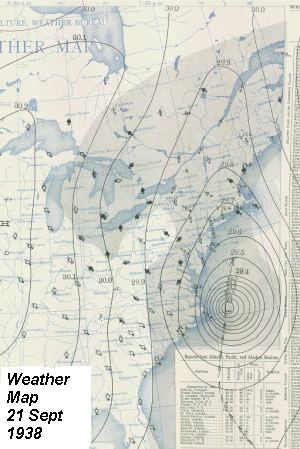
Pierce later placed the hurricane center at 2 PM east of Lakehurst, New Jersey, about midway between Atlantic City and New York City. The hurricane was also moving at a much more rapid pace than the 40 mph speed (64 km/h) — it had been moving at about that pace, based on earlier tracking — Pierce later estimated that it sped along at 70 mph (112 km/h). The speed of its advance thus earned the hurricane the name: The Long Island Express. At 2:30 PM EST, the hurricane hit land at Patchogue, Long Island, crossing the center of Fire Island. The storm surge hit the shoreline with such force that seismographs at nearby Fordham University and as far away as Alaska recorded the impact. (Others likely also recorded the strike.)
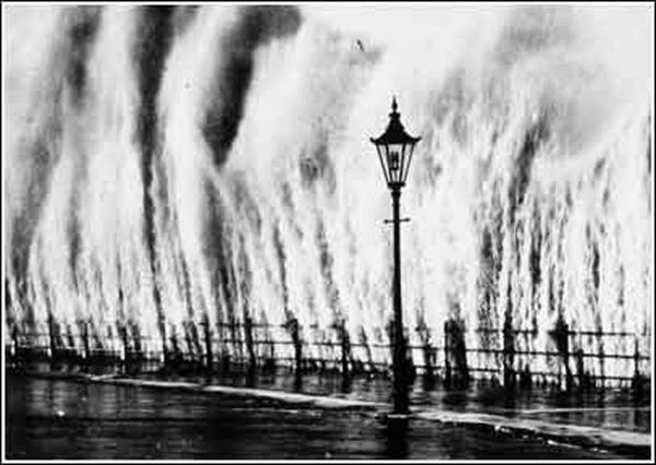
Waves thrash a seawall along the Atlantic coast during the Great Hurricane of 1938.
Photo Couresy NOAA Historic Photo Library
The lowest pressure recorded at a land station during the hurricane occurred at the Coast Guard Station at Bellport, Long Island: 27.94 inches (946.0 mb). Using the pressure reading as a measure of hurricane strength rates The Long Island Express as a Category 3 storm at landfall. Estimated wind speeds on central Long Island were 115-120 mph (184-192 km/h), also fit Category 3 strength, though some wind estimate place the upper limit at 150 mph (240 km/h) which would indicate a Category 4 storm. Because of the storm speed and strength and the nature of the coast, the storm surge likely was extremely high, compounded by the fact it hit at almost the exact time of the autumnal high tide. Estimates for Long Island peg storm surge at 16 feet (4.9 m). Adding to that waves from 15 to 25 feet (4.6-7.6 m) in height suggest a 30-40 foot (9-12 m) wall of water swept across Long Island. Contemporary newspaper reports noted "storm tide" damage to buildings located more that 25-ft (7.6 m) above mean sea level.
When the eye passed over Long Island, it stretched from Bellport to Southhampton, an estimated 30-50 miles (50-80 km) in diameter.
Storm Impacts on New York City and Long Island
To fully detail the human impact of the Long Island Express as it roared across Long Island would require many more words more than I intend to write in this essay. I refer readers wishing to know more details and many human interest stories to the well written books on the storm: Sudden Sea by R.A. Scotti; A Wind to Shake the World by Everett S. Allen, and The Long Island Express: Tracking the Hurricane of 1938 by Roger K. Brickner. Here are a few of the particulars.
Though New York City received only a glancing blow from the vicious storm, it did not escape unscathed. Pushed by the gale winds and high tides, the East River overflowed and covered three blocks into Manhattan, bursting steam pipes under the streets. Power losses blacked out the Bronx forcing hospitals to operate by candlelight. The winds atop the Empire State Building reached 120 mph (192 km/h).
The hurricane took over 50 lives on Long Island, and perhaps many more were uncounted as bodies were washed to sea. The greatest death toll came at Westhampton where 28 died. Of the 179 houses that stood on its shoreline, 153 were torn to shreds by the storm surge and winds. On Fire Island, 300 houses and cottages at Ocean Beach were swept away, 100 each disappeared at Saltaire. Fair Harbor and Montauk were destroyed. The total cost of the storm for Long Island alone was estimated to be $6.2 million, over $91 million in 2007 dollars.
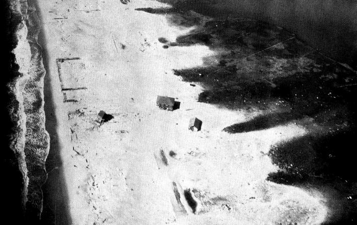
The eastern end of Fire Island, NY near Moriches Inlet after the 1938 hurricane. The main road
through the island is just visible in the center of the lower portion of the photograph. More than
200 homes had been perched on dunes 20 feet high. Photo Courtesy Mitchell Field, 2nd Air Base Squadron - U.S. Army, NY, 1938
The combination of wind and storm surge flattened a third of the buildings along the coast of eastern Long Island. The surf took out the Dune Road area at Westhampton Beach and the tracks of the Long Island Railroad. On the eastern end of Fire Island, the surge swept nearly everything away including more than 200 homes perched on the dunes. Many boats were driven far inland. The Shinnecock Bay Coast Guard Station was washed to sea along with its steel lookout tower and hundred-foot radio mast.
The hurricane-force winds twisted a number of 300-foot (91.5 m) steel and concrete-bolted RCA radio towers into unrecognizable shapes. It also took down the famous steeple on the Presbyterian church at Sag Harbor. The 100-year-old church steeple reached more than 125 feet (28 m) into the air and a light in it had guided Long Island fishermen and whalers home for generations. The winds tore the steeple from the church and smashed it to the ground twenty feet away (6 m), fortunately the remainder of the church was spared.
Around Bridgehampton, island farmers suffered heavy loses; nearly 50 barns plus garages, chicken houses, and outbuildings were levelled from Water Mill to Wainscott. Fields of potatoes planted near the ocean were washed out, washed away, or buried deep beneath sand transported from the beach. From East Hampton eastward, the storm took its toll on the fishermen and their families. At Montauk, 150 of their homes were destroyed and more than 80 good-sized fishing craft were badly damaged or wrecked. So too were scores of dragnets and fish traps. The hurricane also wiped out clam and oyster industries as tons of sand smothered the entire harvest.
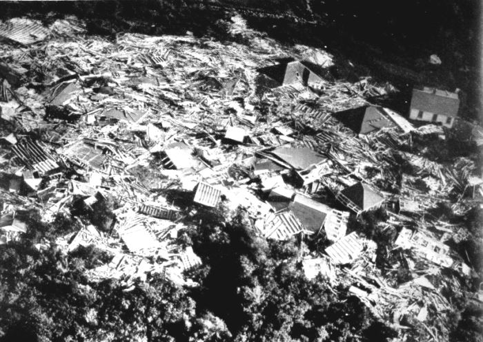
Results of hurricane storm surge from the New England Hurricane of 1938 Photo Courtesy Historic NWS Collection
Crossing Long Island, the Express set its destination as the southern New England coastline from Connecticut to Massachusetts.
For More Weather Doctor articles, go to our Site Map.
I have recently added many of my lifetime collection of photographs and art works to an on-line shop where you can purchase notecards, posters, and greeting cards, etc. of my best images.


 Though the hurricane passed Atlantic City, New Jersey out to sea, the signs that a major storm was out there were unmistakable. Heaving seas and thick spray battered against Steel Pier, and the barometer dropped from 29.50 inches (998.9 mb) to 29.23 inches (989.7 mb) in two hours. Winds rose from 23 mph to 43 mph (37 to 69 km/h) from the northwest, and heavy rains began to fall. A falling barometer with strong northwest winds was not a normal poor-weather situation but indications of a strong storm offshore and moving closer.