When it was born in early September 1938 off the African coast near the Cape Verde Islands as a tropical disturbance, no one knew what its future strength and path would be. But this storm had infamy in its stars. When in became a tropical storm somewhere in the southern reaches of the North Atlantic Ocean, it did not automatically receive a name — the practice of naming tropical storms in the Atlantic was over a decade away and storms were only named when they reached a degree of notoriety. Nor did it earn a name when it first burst into full hurricane force as it approached the Bahamas. Soon however, this hurricane would earn several names — the Great Hurricane of 1938; the Long Island Express; and the Great New England Hurricane — and would rank in the history books as one of the most devastating hurricanes to hit the American Northeast Coast since Europeans colonized the region. At the time, this hurricane was called "America's costliest disaster."
A Storm Is Born
In the days before satellite observations of the tropical Atlantic, tropical storms remained hidden at sea until they hit a populated island or continental coast or crossed paths with one of the many ships travelling the southern North Atlantic Ocean. With hindsight, we can deduce that this storm likely began as a tropical wave around 9 September at 17oN, 13-14oW, about 200 miles (320 km) west southwest of the Cape Verde Islands. Ivan Tannehill of the US Weather Bureau in his Monthly Weather Review summary of the storm suggested that "There was some evidence of cyclonic circulation central about 19oN, 37oW, on the morning of September 13, 1938, but the storm has not been definitely charted prior to the evening of September 16, when it appears to have become a fully developed hurricane."
The first confirmed report of a hurricane blowing in the Atlantic came on late on 16 September when the captain of a Brazilian freighter, the SS Alegrete, encountered the storm 350 miles ( 560 km) northeast of Puerto Rico and radioed a warning to the US Weather Bureau. He put the storm's position at approximately 21oN, 52oW and gave a barometer reading of 28.31 inches Hg (958.6 mb), suggesting he was close to the center of the hurricane, perhaps 100 miles (160 km) to the north. He reported the winds blowing at wind force 12, hurricane force on the Beaufort Scale. Based on the Alegrete pressure observations, we can deduce that the hurricane was at least a Category 3 storm using the Saffir-Simpson minimum pressure criteria, but since the vessel was not in the storm's eye, its strength might have been at least a category greater.
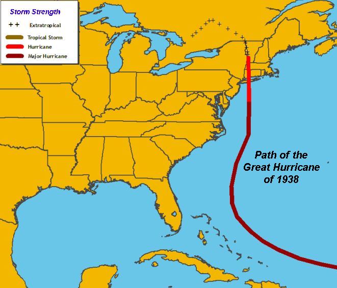
Path of Great Hurricane of 1938 Courtesy NOAA
The following morning, the SS Socrates out of the Netherlands crossed paths with the tempest near 22oN, 59oW. On the 18th, the British SS Corrales reported a pressure of 27.90 inches (944.7 mb). A pressure below 27 inches (924 mb) was also reported by the British SS Carinthia on 20 September: 27.85 inches (943.0 mb). Tannehill suggested that based on ship's pressure observations, the central pressure of this hurricane while at sea remained below 28 inches (948 mb) from "late on the 16th and continuing until the center moved inland near New Haven [Connecticut] on the afternoon of the 21st."
Off The Coast
As the storm approached the US coast, a strong ridge of tropical air sat over the southeastern US, extending from Virginia to southern Florida. In northern New England, another high pressure cell moved very slowly eastward heading into the Atlantic. Between the two, a low pressure cell over Michigan drew the moist tropical air onto the US Atlantic coast, bringing relatively heavy rains to the northeastern states from New Jersey northward. The rainfall was welcome at the time, coming at the end of an extremely hot summer, but in saturating the soil, these rains set the stage for the disaster that was shortly to arrive in New England.
By the evening of 18 September, ship reports put the hurricane around 200 miles (320 km) north of Puerto Rico, heading slowly west northwest at 20 mph (32 km/h). A straight-line extrapolation of that path would place the storm in the Bahamas within 24 hours, and the US Weather Bureau forecast office at Jacksonville, Florida became concerned about its threat to the Florida coast. Only three years earlier on Labor Day, an extreme hurricane devastated the Florida Keys and south Florida. It sported the lowest pressure ever recorded on the continental Unites States 26.35 inches (892.2 mb) and has been categorized as a Category 5 storm. The Labor Day Hurricane claimed over 400 lives.
Meanwhile to the north, the convergence of very moist tropical air and cooler continental air triggered downpours over New York and southern New England. Mineola NY in Nassau County on Long Island reported 3.10 inches (78.7 mm) of rain on the 18th. Hartford and New Haven, Connecticut also received over an inch of rain: 2.45 inches (62.2 mm) and 1.62 inches (41.1 mm), respectively. This rainfall soaked the soil and raised streams to flood stage. Added heavy rainfall on the 19th further drenched the ground and filled the watercourses. Greenfield, Massachusetts reported 4.34 inches (110.2 mm), giving a three-day (17-19 September) total of 5.08 inches (129.0 mm). The rain at Hartford totalled 4.85 inches (123.2 mm) for the three days. Bridgeport, Connecticut measured 3.08 inches (78.2 mm) for the day and Hillsboro, New Hampshire received 2.66 inches (67.6 mm).
The hurricane still spun far to the south of the Northeast States, located at 7 AM EST Monday 19 September about 24oN, 70oW, some 650 miles (1045 km) east southeast of Miami, Florida and moving west-northwestward at around 20 mph (32 km/h). It was, however, close enough to the US coastline for the US Weather Bureau's Jacksonville (FL) office to issue storm warnings for the Florida coast from Key West to Jacksonville. They forecast the storm to hit the Florida east coast by Tuesday morning. At 1 PM, Cat Island in the Bahamas reported a pressure of 29.60 inches (1002.3 mb), but the barometer's slow fall indicated that the storm might be curving northward.
By 9 PM, the Forecast Office, under the capable eyes of hurricane forecasters Grady Norton and Gordon Dunn, had reconsidered the storm's threat to Florida and downgraded its warning for the Florida coast. Their advisory statement placed the hurricane at about 420 miles (670 km) due east of Miami near 25oN, 73oW with its trajectory projected to turn northwestward with further northern curvature in the next 24 hours. They concluded: "Storm threat to Florida east coast has greatly diminished." The influence of the tropical air mass on the continent had caused the turn and, with the upper air flow blowing strongly from the south to southwest, recurved the storm path away from the continent. The hurricane's forward movement diminished to around 15 mph (25 km/h) as it swung to the north northwest.
As the clock ticked into the early hours of 20 September, the Jacksonville forecast office continued to watch the hurricane recurve away from the Florida coast. Their 2:30 AM statement lessened the threat to Florida, though not the need for vigilance should the storm make some odd course change, and put the focus on the waters from east of Palm Beach northward to Cape Hatteras (North Carolina). Their statement described the storm thus: "Severe hurricane with central pressure about 28 inches was centered at 1 AM, EST near latitude 26o 30' north, longitude 75o west moving northwestward about 17 miles per hour. This position is about 350 miles east of Palm Beach."
The morning advisory (9:30 AM) shifted the attention northward: "Northeast storm warnings ordered 9:30 AM, EST North Carolina coast between Wilmington and Cape Hatteras. Hurricane of great intensity central 7 AM, EST near latitude 28o north, longitude 75o west which is about 300 miles east of Vero Beach, Florida, now moving north-northwestward about 17 miles per hour....Lowest pressure reported during night 27.90"."
They foresaw the hurricane center passing Cape Hatteras at some distance offshore but cautioned gale force winds could extend along the coast. At the same time, the frontal wave located near Long Island trailed a cold front down the coast that passed through Cape Hatteras later that evening. The weather indications there showed that Hatteras would not be under the warm air for several days. Rain continued to fall in the Northeast as the forerunning tropical air met with colder air from off the continent. Philadelphia received 2.92 inches (74.2 mm) of rain between 7 PM and 7 AM on the 20th. Hartford collected over an inch (25 mm) as did Hanover, and Mount Washington, New Hampshire. The heavy rains would continue into the night, swelling feeder streams and rivers to flood stages. Many felt the flooding from these rains would rival the flood disaster of two years previous.
The 3 PM advisory from Jacksonville placed the storm about 350 miles (560 km) east of Daytona Beach (29oN, 75oW) moving north-northwestward to northward at about 17 mph (27 km/h) and advised that gales and squalls covered a large area around the storm. It also forecast: "Storm will gradually turn toward the north and north-northeast and move rapidly during the next 36 hours with center passing some distance east of Cape Hatteras late tonight or Wednesday morning."
The 9:30 PM advisory placed the storm about 400 miles (640 km) to the east of Jacksonville headed almost due north and turning further northeastward over the next 24 hours. Storm warnings now covered the US coast from north of Wilmington, North Carolina to Atlantic City, New Jersey.
In the Northeast and especially in southern New England, the worry was over the drenching and unrelenting rainfall, still unassociated with the hurricane hundreds of miles to the south. At Hartford, between the hours of 8 PM on the 20th and 2 AM on the 21st, an additional 3.25 inches (82.6 mm) of rain fell in cloudbursts. Over twelve hours, the accumulation measured 5.47 inches (138.9 mm). Earthen dams began to collapse under the pressure. One at Stafford, Connecticut dumped its water into the Willimantic River, flooding the city of Willimantic and washing away buildings and machinery of the American Thread Company.
The advisory at 3 AM EST on the 21st would be Jacksonville's last before turning the duty of watching this hurricane to the Washington DC Weather Bureau forecasters. It located the hurricane about 275 miles (440 km) south of Cape Hatteras and moving rapidly north, perhaps northeast. Dangerous gales with hurricane-force winds offshore and high tides along the coast were forecast, and thus the storm warnings issued earlier remained in effect. Given the projected movement direction at a speed of 40 mph (64 km/h) — a reasonable storm speed at these — latitudes, it is surprising that warnings did not extend north of Atlantic City, New Jersey, particularly for marine traffic. What followed next damaged the reputation of Weather Bureau forecasters for years. They "lost" it.
In Roger K. Brickner's excellent account of the tracking of the hurricane The Long Island Express, he felt it strange that no alerts or warnings were issued for further north of the southern New Jersey coast considering the hurricane was described as "severe" and was not dissipating. He also wondered why the latitude/longitude of the storm had been dropped in the last advisory, its location given only as "about 275 miles south of Cape Hatteras." In actual fact, as later re-analysis would show, the storm was actually 60 miles (96 km) further north, and a bit east, of that position.
At 7:30 AM, 21 September 1938, the weather map placed the storm 140 miles (225 km) east northeast of Cape Hatteras at 35o 20' N, 73oW. Its central pressure was given as 28.00 inches (948.1 mb). Cape Hatteras reported 55 mph (88 km/h)winds blowing from the northwest. Misguided by the weather advisories, the Cunard Liner Carinthia had kept closer to the coast than her originally intended course in order to avoid the hurricane, but unfortunately, this took her almost directly into the eye. Her captain A. C. Greig reported hurricane winds and a barometric pressure of 27.75 inches (939.6mb).
The heavy rains continued overnight in New England and New York. Several locations inland (e.g. Albany, New York; Concord and Hanover, New Hampshire) reported over an inch (25 mm) of accumulation. The Connecticut River and its tributaries reached flood level or just shy of it.
The responsibility for tracking and warning now fell on the Washington Office. Junior forecaster Charles Pierce was assigned to keep track of the storm, replacing a senior meteorologist who was on vacation. According to R.A. Scotti, author of Sudden Storm, the senior Washington forecasters decided to downgrad the storm to a tropical disturbance and did not include the hurricane on the morning weather map sent out to regional newspapers and radio stations. It was, however, plotted on the official daily weather map for 7:30 AM EST. Their early-morning forecast for the northeast Atlantic Coast stated: "A broad trough of low pressure extends from New England south-southwestward to the tropical disturbance." Pierce, apparently, was not so convinced, but being the junior meteorologist, he did not initially question his superiors.
The first advisory from Washington, written by Pierce, was issued at 9 AM EST. "Northeast storm warnings ordered north of Atlantic City and south of Block Island and southeast storm warnings ordered Block Island to Eastport, Maine. Tropical storm apparently central about 75 miles east of Cape Hatteras moving rapidly north-northeastward...."
As you can see, Pierce did not call the storm a hurricane in his advisory as requested by his senior forecasters but did not go so far as to call it only a "tropical disturbance." During the morning, he had reanalyzed his charts and felt convinced that the storm off the Virginia coast was still a force to be reckoned with. One of his points of argument was the extreme low pressure reported by the Carinthia which showed the storm was still a hurricane....and a severe one. His analysis, he believed, showed the "disturbance" was indeed a hurricane headed northward at a rapid pace and aimed directly at New England.
Unfortunately, Chief Forecaster Charles Mitchell did not agree. All the experience of forecasting hurricanes at this latitude, he said, showed they veered out to sea where the colder waters would degrade them. Mitchell and his fellow senior forecasters rejected Pierce's analysis. The storm was but a Cape Verde Blow.
Brickner noted that the location given in the advisory put the storm center much closer to the coast than its actual location. He also speculated that by putting the storm closer to Hatteras, the Washington forecasters probably thought it had downgraded to a tropical storm and no longer posed a serious threat to the coastal areas further north.
In his postmortem analysis paper on the storm, however, Pierce stated that from 7:30 AM to 11 AM, the storm showed rapid movement northward and now lay off Norfolk, Virginia. The storm had now accelerated its forward motion to 70 mph (112 km/h). Within hours, it would strike the US coast and race over Long Island earning it the nickname The Long Island Express.
For More Weather Doctor articles, go to our Site Map.
I have recently added many of my lifetime collection of photographs and art works to an on-line shop where you can purchase notecards, posters, and greeting cards, etc. of my best images.


 When it was born in early September 1938 off the African coast near the Cape Verde Islands as a tropical disturbance, no one knew what its future strength and path would be. But this storm had infamy in its stars. When in became a tropical storm somewhere in the southern reaches of the North Atlantic Ocean, it did not automatically receive a name — the practice of naming tropical storms in the Atlantic was over a decade away and storms were only named when they reached a degree of notoriety. Nor did it earn a name when it first burst into full hurricane force as it approached the Bahamas. Soon however, this hurricane would earn several names — the Great Hurricane of 1938; the Long Island Express; and the Great New England Hurricane — and would rank in the history books as one of the most devastating hurricanes to hit the American Northeast Coast since Europeans colonized the region. At the time, this hurricane was called "America's costliest disaster."
 By 9 PM, the Forecast Office, under the capable eyes of hurricane forecasters Grady Norton and Gordon Dunn, had reconsidered the storm's threat to Florida and downgraded its warning for the Florida coast. Their advisory statement placed the hurricane at about 420 miles (670 km) due east of Miami near 25oN, 73oW with its trajectory projected to turn northwestward with further northern curvature in the next 24 hours. They concluded: "Storm threat to Florida east coast has greatly diminished." The influence of the tropical air mass on the continent had caused the turn and, with the upper air flow blowing strongly from the south to southwest, recurved the storm path away from the continent. The hurricane's forward movement diminished to around 15 mph (25 km/h) as it swung to the north northwest.
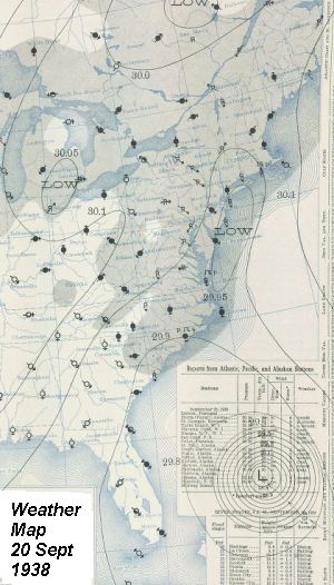 They foresaw the hurricane center passing Cape Hatteras at some distance offshore but cautioned gale force winds could extend along the coast. At the same time, the frontal wave located near Long Island trailed a cold front down the coast that passed through Cape Hatteras later that evening. The weather indications there showed that Hatteras would not be under the warm air for several days. Rain continued to fall in the Northeast as the forerunning tropical air met with colder air from off the continent. Philadelphia received 2.92 inches (74.2 mm) of rain between 7 PM and 7 AM on the 20th. Hartford collected over an inch (25 mm) as did Hanover, and Mount Washington, New Hampshire. The heavy rains would continue into the night, swelling feeder streams and rivers to flood stages. Many felt the flooding from these rains would rival the flood disaster of two years previous.