Before I wrap this discussion up. I do want to give you a list of some interesting things to look for
in the sky. They are generally common, but some may be seasonal in your region. All are quite
fascinating, and I throw in a bit of science here to explain why they occur.
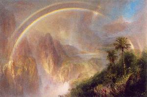
1. The Double Rainbow
By double rainbow, I am referring to the main primary rainbow with a secondary rainbow that
forms outside the primary bow. The secondary bow is weaker in brightness than the primary (it
forms from a second reflection in raindrops, rather than from just one as with the primary bow), and its
colours are reversed in order. In the primary bow, blue is on the inner edge with red on the outer.
In the secondary bow, the red is on the inner edge and blue the outer. In between the two bows
you will see a much darker region known as Alexander's dark band (not his ragtime band). The
centre of the rainbow is usually much brighter than the rest of the sky due to sunlight reflecting
directly back from the droplets to the viewer.
Frederic E. Church's painting Rainy Season in the Tropics gives a rendition of the double rainbow with Alexander's dark band well portrayed.
A hint for rainbow hunting: if you think conditions are right for a rainbow -- rain showers falling
opposite the sun which may just be peeking through clouds -- put the sun to your back and look
to a point opposite the sun such that rays from the sun would pass through your head. This is the
antisolar point and will be the centre of any rainbow. If the sun is high, the rainbow will be closer
to the horizon. If it is too high, a rainbow may not be visible at all unless you have a high vantage
point such as a mountain top or aircraft. [For more on rainbows, click here.]
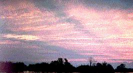
2. Crepuscular Rays
Crepuscular (twilight) rays appear as dark and light shafts of light that extend outward from the
sun. They are most often seen around sunrise or sunset, but may be seen at other times. Bright rays occur where sunlight shines between the clouds illuminating the air across a region of sky -- the darker the clouds, generally the brighter the rays appear. Dark rays form when clouds cast their shadows on the surrounding air. Although the suns rays are actually parallel, crepuscular rays appear to converge on the sun. This is the same perspective image we see when railroad tracks appear to meet at a single point in the far distance. [For more, click here.]
3. Thunder Following Lightning's Path
Since thunder is caused by the rapid heating of the air during the passage of a lightning stroke, the
path of thunder always follows that of the lightning. If lightning strikes very far away or vertically
close to the observer, the times required for the sound to reach our ears from the extreme ends of
the lightning path are similar, and the thunder sounds as if it comes from one area of the sky.
However, if the bolt crosses the sky from side to side, or perhaps has a path that looks to us like an
inverted letter L, the thunder reaches our ears from points along the path at distinctly different
times. When the lightning is overhead and shoots across the sky, the thunder often sounds as if
someone is ripping the fabric of the heavens above us. [For more on thunder watching, click here.]
Thunder can sound as if it is coming from a direction different than the lightning, however.
Thunder, like any sound, can echo off topographical features such as mountains or canyon walls,
or off buildings. I once had the odd sensation in an urban street canyon of hearing thunder to my
right even though I knew the lighting had struck to my left. The buildings on the left of the street
muffled the direct sound wave to me. However, the sound reflected off the highrise to my right
giving a louder clap than the direct wave. [For more on thunder, click here.]
4. Fair-Weather Cumulus
Have you noticed that during some fair-weather afternoons, small cumulus clouds form scattered
across the sky, each appearing flat bottomed along a straight line at exactly the same level, while
the rest of the cloud was lumpy and irregular? Well, they were pretty much at exactly the same
altitude. Meteorologists call this the lifting condensation level, the height above the ground where
water vapour in a lifted parcel of air begins to condense into a cloud. Here is how these clouds are
formed.
In the daytime (usually several hours after sunrise) on a clear day, the sun heats the surface until
the air in contact with the ground is warmer than the surrounding air. Every once in a while,
bubbles of warmer air break away and rise into the sky. If they are warm enough or large enough,
they can rise until they reach the lifting condensation level. Here, the invisible water vapour within
the bubble begins to condense and to form visible liquid cloud droplets. On such days, the
conditions are usually not right for forming large cumulus clouds with showers, so these visible
expressions of rising heat remain small. Thus the name, fair-weather cumulus. [For more on clouds, click here.]
If you took a time-lapse movie of the sky under these conditions, you would actually see that
individual clouds have a relatively short lifetime, boiling up and then melting away. If you have the
patience to watch an individual cloud closely, you will see that it disappears rather quickly, about
10 to 20 minutes after forming, although the sky appears to have a fairly consistent cloud cover. In
early evening when the sun's heating begins to weaken, the formation of the warm bubbles ceases,
and no further clouds form, leaving the night sky generally clear.
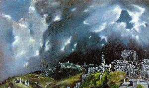
5. Looking for the Silver Lining
When we view thick, irregular and scattered clouds such as those of the cumulus family between
us and the sun, the edges often shine brightly. This is called the cloud's silver lining, which under
certain conditions near sunrise or sunset can become a golden lining. The cloud's edges are much
thinner than its main body; thus they are more efficient at scattering light forward toward our eyes.
When the contrast is great, the edges appear brilliant and metallic in appearance.
In contrast to the silver lining, when we are between the sun and cloud, the cloud's central portion
reflects more light than the edges, which now appear relatively dark. Thus, not all clouds have a
silver (or golden) lining.
The silver lining is well depicted in the sky above El Greco's Toledo.
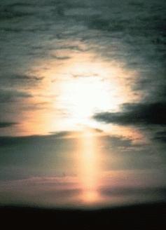
6. Pillars, Halos and Sun Dogs
There are a whole range of optical phenomena we may see when sunlight passes through clouds
made of ice crystals: halos, pillars, arcs and sundogs -- to name a few. Most often these clouds
are members of the high altitude family known as cirrus. Occasionally in winter, lower clouds and
fog near the earth's surface can be composed of ice crystals. Blowing snow or light snow falling as
showers may also place ice crystals in the air between us and the sun which can produce halos,
pillars and sun dogs.
Sun Pillar: Photo Courtesy of NOAA/US Dept of Commerce
What we see depends on the path the sunlight (or a strong light source such as street lighting) takes
as it passes through the ice crystal. Unlike cloud droplets or raindrops, which are fairly spherical in
shape, ice crystals (including individual snow flakes) offer a number of different shapes to the
passing light rays. In effect, the crystals act as prisms refracting and reflecting light as it passes
through, and these crystals are rarely steady -- tumbling, twisting and turning as they move
through the atmosphere. [For more on pillars, click here.]
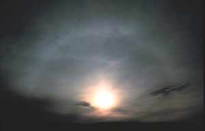
Solar Halo: Photo Courtesy of NOAA/US Dept of Commerce
Halos are bright, often colourful rings, arcs and spots. We usually think of halos as being circles,
but few actually are. Halos generally appear red, orange or yellow in colour. The most common,
the 22o halo, forms a pearly, milky ring around the sun. Its name stems from its location relative to
the sun: at an angle of 22o from the solar disk centre. Between the halo and the solar disk is a
darker region, similar the Alexander's dark band, so that there appears to be a hole in the sky
between the two bright areas. In very thin clouds, the sun can be very bright so be careful when
looking toward the sun. It is usually best to hold up a hand or some other object to shade the eyes
from the direct sun. The halo often becomes more visible then because the eyes are not
overwhelmed by the sun's brightness. [For more on haloes, click here.]
I could go on for pages describing the many other features formed by a strong light source and ice
crystals. I will mention one other here: the sundogs. Sundogs (technically parhelia) are bright,
often strongly coloured, spots in cirrus clouds, ice fogs, or sometimes blowing snow. They can
form on both sides of the sun, but often we see only one. They appear at the same altitude as the
sun and are reddish on the side facing the solar disk, often with bluish tails stretching horizontally
away from the sun. Sundogs are usually much brighter than halos, at times forming a bright spot
on the 22o halo. [For more on sundogs, click here.]
7. Mirages
By definition, a mirage is a image of something that is not actually there, an illusion. When we
think of mirages, we generally think of deserts and the illusion of watery oases. In fact, mirages are
very common. For example, unless obscured by clouds or topography, the image we see of the sun
just rising or setting on the horizon is a mirage, for the sun is actually below the line of direct sight
to the horizon. In the atmosphere, mirages are categorized as either an inferior mirage or a
superior mirage. These names have nothing to do with their quality of the vision, but refer to their
visual position relative to the horizon: inferior below the horizon, superior above.
We most often see the inferior mirage. Nowadays this mirage is so common we almost don't think
about it. Have you ever seen water on the highway only to watch it disappear as you moved
closer? That was an inferior mirage (today called the highway mirage) and is the image of the blue
sky appearing on the surface. Inferior mirages occur when the air close to the surface is much
warmer than that above it. Thus the desert mirage is an inferior mirage. Skylight passing through
this air is bent by refraction so that it appears to be coming from a source below the horizon. In
days long past, such mirages were only common over hot surfaces like deserts or beaches or bare
rock, but today the abundance of paved areas and other human-made surfaces (such as artificial
turf) can easily heat to temperatures high enough to produce strong mirages.
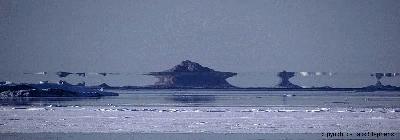
The superior mirage forms above the horizon and is seen where warm air overlies cold air, a
condition known as a temperature inversion. Superior mirages can be quite common over cold
water and snow surfaces. Here in Victoria, British Columbia, the colder waters surrounding
Vancouver Island provide ideal conditions for superior mirage viewing. Most often they are
evident through an apparent increase in the height of the Olympic Mountains to the south. The
mountains may even appear to change their height as one travels around town! There are several
areas approaching the city core where the Olympics appear to tower to great heights, a
disappointment to those tourists who rush to the shoreline only to find much smaller mountains
rising across the strait.
Superior mirages can distort the horizon or bring images of topography located below the horizon
into view. Several historians believe that the images of ice mountain ranges (which were really
icebergs or sea ice) caused by superior mirages in the high North Atlantic encouraged the Vikings
in Greenland to explore lands to the west and thus they discovered North America. Superior
mirages may also invert an image. For example, a sailboat may appear in the distance with its mast
pointing down to the water.
When there are multiple temperature layers in the atmosphere, light rays can be bent to produce a
variety of interesting illusions. One is known as the Fata Morgana, which legend ascribes to the
fairy castles of Morgana that magically disappear as the seeker approaches. This mirage causes
distant objects, and even the horizon, to appear as growing spikes and shoots, like the battlements
of castles.
The twinkling (or scintillation) of stars is the result of the light rays being bent (refracted) and
dispersed from their direct path by passing through air of varying density. The twinkling of stars is
strongest when the sky is clear and it is windy, at least at higher altitudes. Stars nearer the horizon
twinkle more than those overhead because there is more atmosphere through which the light must
pass.
Street lights in the distance may also twinkle and shimmer, but here density variations in the air
much closer to the ground are responsible. Remember the bubbles of warm air which produce
fair-weather cumulus? Well, they have weaker cousins which form over urban areas, large bodies
of water or rocky surfaces at night. When these bubbles move between us and low light source, we
see the distant light shimmer and twinkle -- the further the light source, the greater the effect. [For more, click here.]
9. Brighter Skies During Heaviest Showers
Ever notice that just before a heavy daytime downpour, it gets very dark only to brighten
considerably once the deluge begins? This brightening is due to the scattering and reflections of
sun and skylight by the droplets as they fall. The larger the droplets, the greater the brightening. [For more, click here.]
Okay, I should have quit long ago with this list, but I got on a roll and I can't stop with just nine in
the list. What would David Letterman think? So here is Number 10. Most of the above have been
things you could see. This one will be one that is better felt, although you can see it indirectly.
10. Daily Wind Variability
There is an old saying: "The winds of the day do wrestle and fight, longer and stronger than those
of the night." The same process that forms fair-weather cumulus is also responsible for higher
wind speeds during the day than during the night. (Of course, any nearby storm system may
override this diurnal difference.) The upward movement of the warm air bubbles from the near-calm surface requires that air from above must sink to replace it.The sinking air brings with it the
faster wind from higher altitudes. Without getting too technical, the net effect is to increase the
turbulence level in the atmosphere. Thus, the winds, wrestle and fight, gusting to higher speeds,
then falling back again to near calm. When the sun's heating no longer sustains this mixing of
surface air with that aloft, the winds at the surface revert to their light speeds.
[For more, click here.]
Learn More From These Relevant Books Chosen by The Weather Doctor
Heidorn, Keith C.: And Now...The Weather, 2005, Fifth House Ltd, ISBN 1894856651, 265pp.
For More Weather Doctor articles, go to our Site Map.
I have recently added many of my lifetime collection of photographs and art works to an on-line shop where you can purchase notecards, posters, and greeting cards, etc. of my best images.

 There is an old saying: "The winds of the day do wrestle and fight, longer and stronger than those
of the night." The same process that forms fair-weather cumulus is also responsible for higher
wind speeds during the day than during the night. (Of course, any nearby storm system may
override this diurnal difference.) The upward movement of the warm air bubbles from the near-calm surface requires that air from above must sink to replace it.The sinking air brings with it the
faster wind from higher altitudes. Without getting too technical, the net effect is to increase the
turbulence level in the atmosphere. Thus, the winds, wrestle and fight, gusting to higher speeds,
then falling back again to near calm. When the sun's heating no longer sustains this mixing of
surface air with that aloft, the winds at the surface revert to their light speeds.
[For more, click here.]
There is an old saying: "The winds of the day do wrestle and fight, longer and stronger than those
of the night." The same process that forms fair-weather cumulus is also responsible for higher
wind speeds during the day than during the night. (Of course, any nearby storm system may
override this diurnal difference.) The upward movement of the warm air bubbles from the near-calm surface requires that air from above must sink to replace it.The sinking air brings with it the
faster wind from higher altitudes. Without getting too technical, the net effect is to increase the
turbulence level in the atmosphere. Thus, the winds, wrestle and fight, gusting to higher speeds,
then falling back again to near calm. When the sun's heating no longer sustains this mixing of
surface air with that aloft, the winds at the surface revert to their light speeds.
[For more, click here.]


 Crepuscular (twilight) rays appear as dark and light shafts of light that extend outward from the
sun. They are most often seen around sunrise or sunset, but may be seen at other times. Bright rays occur where sunlight shines between the clouds illuminating the air across a region of sky -- the darker the clouds, generally the brighter the rays appear. Dark rays form when clouds cast their shadows on the surrounding air. Although the suns rays are actually parallel, crepuscular rays appear to converge on the sun. This is the same perspective image we see when railroad tracks appear to meet at a single point in the far distance. [For more, click
Crepuscular (twilight) rays appear as dark and light shafts of light that extend outward from the
sun. They are most often seen around sunrise or sunset, but may be seen at other times. Bright rays occur where sunlight shines between the clouds illuminating the air across a region of sky -- the darker the clouds, generally the brighter the rays appear. Dark rays form when clouds cast their shadows on the surrounding air. Although the suns rays are actually parallel, crepuscular rays appear to converge on the sun. This is the same perspective image we see when railroad tracks appear to meet at a single point in the far distance. [For more, click  Since thunder is caused by the rapid heating of the air during the passage of a lightning stroke, the
path of thunder always follows that of the lightning. If lightning strikes very far away or vertically
close to the observer, the times required for the sound to reach our ears from the extreme ends of
the lightning path are similar, and the thunder sounds as if it comes from one area of the sky.
However, if the bolt crosses the sky from side to side, or perhaps has a path that looks to us like an
inverted letter L, the thunder reaches our ears from points along the path at distinctly different
times. When the lightning is overhead and shoots across the sky, the thunder often sounds as if
someone is ripping the fabric of the heavens above us. [For more on thunder watching, click
Since thunder is caused by the rapid heating of the air during the passage of a lightning stroke, the
path of thunder always follows that of the lightning. If lightning strikes very far away or vertically
close to the observer, the times required for the sound to reach our ears from the extreme ends of
the lightning path are similar, and the thunder sounds as if it comes from one area of the sky.
However, if the bolt crosses the sky from side to side, or perhaps has a path that looks to us like an
inverted letter L, the thunder reaches our ears from points along the path at distinctly different
times. When the lightning is overhead and shoots across the sky, the thunder often sounds as if
someone is ripping the fabric of the heavens above us. [For more on thunder watching, click 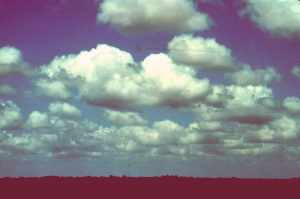 Have you noticed that during some fair-weather afternoons, small cumulus clouds form scattered
across the sky, each appearing flat bottomed along a straight line at exactly the same level, while
the rest of the cloud was lumpy and irregular? Well, they were pretty much at exactly the same
altitude. Meteorologists call this the lifting condensation level, the height above the ground where
water vapour in a lifted parcel of air begins to condense into a cloud. Here is how these clouds are
formed.
Have you noticed that during some fair-weather afternoons, small cumulus clouds form scattered
across the sky, each appearing flat bottomed along a straight line at exactly the same level, while
the rest of the cloud was lumpy and irregular? Well, they were pretty much at exactly the same
altitude. Meteorologists call this the lifting condensation level, the height above the ground where
water vapour in a lifted parcel of air begins to condense into a cloud. Here is how these clouds are
formed.