1965 Palm Sunday Tornado Outbreak Part III: Last Strikes and Aftermath
The Last Severe Weather Forecast of this day was issued at 8:10 pm EST for a large portion of Indiana, the extreme southeast corner of Michigan, and the northwestern quarter of Ohio. The forecast expected the severe weather to continue until midnight.
SEVERE WEATHER FORECAST NUMBER 72
ISSUED 710 PM CST APRIL 11, 1965
PORTIONS OF INDIANA
THE NORTHWEST PORTION OF OHIO AND
PORTIONS OF SOUTHEAST MICHIGAN
SCATTERED SEVERE THUNDERSTORMS WITH A FEW TORNADOES LARGE HAIL DAMAGING WIND STORMS ARE EXPECTED IN AN AREA ALONG AND 60 MILES EITHER SIDE OF A LINE FROM 60 MILES SOUTHWEST OF INDIANAPOLIS INDIANA TO 20 MILES SOUTH OF DETROIT MICHIGAN FROM 8 PM TO MIDNIGHT CST THIS SUNDAY EVENING.
CRUMRINE
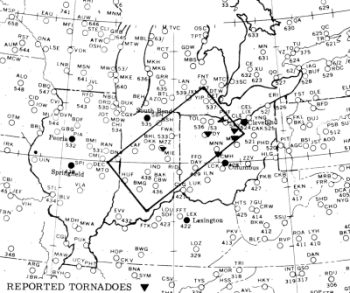
SELS Severe Weather Forecast 72: Forecast Zone Source: US Weather Bureau Survey Team Report May 1965
Ohio Tornadoes
When the last tornadic activity ended in the westernmost of the six states involved in this outbreak, Ohio entered into its crosshairs. The first Ohio tornado entered from Indiana around 8:30 EST. When the last tornado, a weak F1, dissipated after midnight (1 am) in Harrison County in eastern Ohio, the Buckeye State had been visited by six tornado families. It was to be the second deadliest tornado day in the state's history — the Lorain tornado of 28 June 1924 being the deadliest — with between 55 and 63 fatalities. All tornadoes struck after dark, making the night more horrible to those in the state.
The first significant tornado crossed into northwestern Ohio from Indiana sometime past 8:20 pm EST. This F4 tornado did its most damage along the Mercer–Van Wert County line, south of Wiltshire. Five homes were demolished and five more heavily damaged; a mother and son died in one of those houses.
At 9:30 pm, thirteen died when an F4 tornado rolled across Allen and Hancock Counties, north of Lima. Most died in homes levelled by the tornado. Five minutes later, another F4 touched down in Lucas County and moved through the northern edge of Toledo. Sixteen died in Ohio and two more when the storm moved into Michigan. Four of those fatalities came when the tornado picked up a bus on I-75 — the Toledo�Detroit Expressway — and slammed it to the pavement. Homes, cars and boats were destroyed for a price tag of $25 million. Injuries totalled 236. Reports indicate that twin funnels formed north of Toledo.
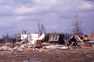
Tornado Damage on Summit St, Toledo, Ohio Photo courtesy of Toledo Lucas County Public Library
The next F4 visited Shelby County, moving past the communities of Anna, Swanders and Maplewood around 10 pm. About 25 homes were destroyed and another 20 severely damaged. Three died and 57 were injured. This storm derailed 53 cars of a 68-unit B&O freight train near Swanders and heaved an automobile 200 yards (183 m). The final F4 struck at 10:15 pm in Seneca County, levelling four homes in Rockaway and damaging another three. One person died in one of those homes; thirty were injured.
The worst of these night-terror tornadoes touched down around 11:05 pm outside the small town of Pittsfield. This F5 twister nearly blew Pittsfield off the map while killing seven of the fifty residents. Two others died while driving through town. The funnel levelled all buildings in the town: twelve homes, the town hall, two churches, and a gas station/grocery store. When it struck the Pittsfield Congregational Church, the winds plucked Reverend Elmer Novak and his family from their shelter in the church's basement and dropped them on the front lawn, injured but alive. The storm also took aim at the community's Civil War monument. Though the base of the structure stood the force, the tornado did what the Confederate Army could not. It toppled General Sherman to the ground — the statue that topped the monument.
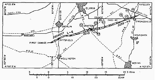
Tornado Track Across Lorran and Cuyahoga Counties, Ohio Source: Fujita, et al, Monthly Weather Review, 1970
Five more fatalities from this tornado occurred near Lagrange when the tornado levelled twenty more homes, and an additional three deaths were registered near Columbia Center. In the last minutes of this tornado's life, it ravaged the northern limits of Strongsville. Eighteen homes "literally vanished" and fifty others were heavily damaged. In total, this twister took 18 lives, injured another 200 and caused damage estimated at $5 million.
At 11:30 pm, two widely separated F3 tornadoes struck the state. The northern one moved across Medina and Summit Counties between Cleveland and Akron destroying a home and heavily damaging several others at Brunswick. No fatalities occurred but six injuries were reported. The second moved across Union, Delaware, and Morrow Counties, killing three directly — another died of a heart attack during the event — and injuring 62, 22 of them at Westfield. The twister passed through the towns of Westfield and Radnor, the three deaths occurring at the latter location.
The final significant tornado of the outbreak actually came on 12 April. Half and hour into the new day, an F2 funnel moved south and east of Columbus across Pickaway, Fairfield and Perry Counties. The greatest damage occurred along an eight-mile (13 km) track north of Lancaster where farm buildings were destroyed. One death and 20 injuries were attributed to this final killer tornado.
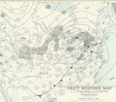
Surface Weather Map for 12 April 1965 1 AM EST Courtesy: NOAA Central Library Data Imaging Project
Aftermath
The nation awoke on Monday to the terrible news that six states had been raked by a total of at least 37 tornadoes that left 256 Americans dead and over 3100 injured. Indiana sustained property damage estimated at $145 million, while Michigan reported $51 million and Ohio $42.5 million in damages. At the time, only the great Tri-State Tornado of 1925 had killed more Americans on a single day.
Immediately, a US Weather Bureau Survey team was appointed by Weather Bureau Director Robert M. White to tour the stricken areas and assess the damage and analyse what measures were taken and what could be taken to minimize the death and injury toll in future events. Interestingly, in light of recent severe weather incidents, the report was presented to White on 2 May 1965, and many of their recommendations were implemented quickly.
Later, an extensive report was prepared by Dr Ted Fujita and his team from the University of Chicago which looked at the damage patterns and meteorological characteristics of the outbreak. (The report published in the January 1970 issue of Monthly Weather Review formed a prime source for this article. The pdf of the report is available online here.)
One of the big questions put to the survey team was, given that the forecasts from the Severe Local Storms Center ranged from very good to excellent — 33 of the 37 tornadoes occurred within the forecast warning zones — why was the death toll so high?
Official tornado forecasting was less than 15 years old at the time. Prior to that time, the Weather Bureau had actually banned the word tornado from severe weather forecasts, afraid of panicking the public. Given the technology and state of the science of the day, the forecasts for 11 April were highly accurate. The survey team found that local weather offices, who had to reissue the storm forecasts, had "excellent cooperation of the radio and TV stations in broadcasting the forecasts and warnings throughout the affected area."
Despite this, and the determination that many were aware of the severe weather forecasts in some areas, many others in the affected areas were not (myself being one; I was outdoors). Part of the problem was that across the stricken area, this Sunday was one of the first pleasant days of the spring, and many were outdoors away from their radios and TVs. The survey team also reported that "Undoubtably also, because of the balmy weather existing at the time, many considered that this was just another instance of �crying wolf'." They also recognized the fact that while many heard the warnings, their lack of experience with tornadic weather left them not sure exactly what to actually do. (Several local offices such as Chicago did include steps to be taken in their tornado warning messages to the media.)
The team also found weaknesses in the communications systems and the warning system. In some cases, the storm knocked out communications so warnings could not be relayed to nearby communities. They also found that none of the Civil Defense "take cover" warning sirens in the affected region had a arrangement to use the sirens for weather emergencies.
In addition, they determined that the tornado forecast and warning system was not adequately understood by the public. Very few of those surveyed understood the difference between the "forecast" and the "warning," and there was no feeling of urgency to do anything when a warning was issued. Many interpreted the warning to be an update of the forecast, rather than a strong statement of "take cover immediately" because a tornado had been sited in the warning area.
I often find today, that folks assume that our current levels of communication and danger warnings have been in place "forever." But at that time, many broadcast media outlets did not have their top staff on duty, and many of those on duty did not know the protocols for emergencies. "24/7" was not the practice of the day! And professional meteorologists were just beginning to gain acceptance in the media, and usually then only in the larger markets, so there was no "guiding hand" to convey the true nature of the danger in most areas.
The survey team presented several other recommendations which I will not provide here. Several were technical, mostly aimed at enhancing radar and communications at Weather Bureau offices.
The result of this survey was a revamping of the Weather Bureau storm warning system, increased linkages with local civil defense authorities, and the undertaking of an extensive educational program for residents within tornado-affected areas of the country. I recall hearing those civil defense sirens frequently during that summer in northeastern Illinois, perhaps an over-reaction to the Palm Sunday event.
The biggest change, to my mind, was the introduction of the Tornado Watch and Tornado Warning program with attendant public education materials. Now when conditions were ripe for tornado activity, a Tornado Watch would be issued for the affected area, alerting those within to keep an eye and ear out for impending severe conditions. The emphasis then came to the Tornado Warning that the threat was immediate, and shelter should be hastily sought.
As the years passed, the technology and understanding of tornado weather have improved dramatically as has the public communication system. But even with all those advances, there are still gaps in warning protocols. This is particularly true of tornadoes striking late in the evening, often after usual bedtimes when people are not tuned into the broadcast media. Killer tornadoes this year have show this gap, leading to a strong recommendation for those in particularly tornado-prone regions to purchase a radio linked to the NOAA All-Hazards Weather Radio system that will automatically turn on and warn owners of severe storm warnings at any hour.
For More Weather Doctor articles, go to our Site Map.
I have recently added many of my lifetime collection of photographs and art works to an on-line shop where you can purchase notecards, posters, and greeting cards, etc. of my best images.