1965 Palm Sunday Tornado Outbreak Part I: The Beginning
On Palm Sunday, 11 April 1965, the United States reeled under the largest single-day outbreak of tornadoes documented to date in its history. On that day, 47 confirmed tornadoes struck the states of Iowa, Wisconsin, Illinois, Indiana, Michigan and Ohio. (The event is now the second greatest outbreak, surpassed by the April 1974 Super Outbreak.) Across these states, the 12-hour long tornado rampage killed 271 people, injured nearly 3500 more, and incurred property damage that reached over a quarter billion dollars at the time. An adjustment to current dollar value would peg the damage at over $1.6 billion.
The event would have major influences on my life, though I was not at any of the tornado touchdowns, being about 20 miles (32 km) south of the most destructive to hit Northern Illinois that day: The Crystal Lake-Island Lake member of the eastern Illinois-Wisconsin family in the outbreak swooped down through my aunt and uncle's neighborhood, causing almost complete devastation across the street. Fortunately, my aunt, uncle and two cousins were not at home, so there were no physical injuries suffered to them. Their house, however, was a mess.
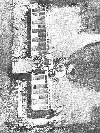
Survey of Tornado Damage, Crystal Lake IL, 12 April 1965 Source: Fujita, et al, Monthly Weather Review, 1970
The aerial photograph of damage given above, taken by the US Weather Bureau Survey Team and reported by Fujita, et al. (1970), shows their neighbourhood about one street off (their street would be just off the picture from the bottom). The lower street in the picture is Keith Avenue, the upper Eugene Court and the connecting street is Union Street. My relative's house would be to the lower right of the picture. As I recall, the view across their street, was similar to that seen in the middle of the picture. I remember all that was left of one house across the street, above the floor boards, was the basement stairwell walls. My relatives were "lucky" as their home remained mostly intact. The chimney next door had blown into my cousin Peggy's bedroom and every window had been shattered into splinters and driven into all the furniture, walls, etc. Given the total devastation to the surrounding homes, they were fortunate to have the main frame rather intact, though damaged.
Addendum: I received a couple of emails (September 2010) from Jenni (Percy) Haas and Janet (Enright) Green whose homes were in the lower corner of the picture above. Here is Jenni's account:
Our houses are the two on the bottom right. The Percy house has a single light colored station wagon in the driveway and the Enrights have two cars on their drive way in a line and one parked out front. Their Ford Galaxy had been in the garage and was caved in but their dad jacked it up and put new glass in and continued to drive it. We were at Tastee Freeze and came home 3 minutes after the tornado went through so our car was fine, but there were something like 7 cars piled in our front yard. My birth certificate was found in Island Lake in someone's freezer. The very top left house is where the 3 people were killed when the truck landed in the basement after the whole foundation was torn off. I wonder where the inspector was the day that one was being built. The lady right behind the Enrights house was killed because she was out taking her laundry off the line. There is nothing left of her house. The Enrights all headed for the basement when they saw screen doors flying thru the air....Our family [Percy's] moved to California 10 months after the tornado but the Enright's stayed there and their mom still lives in that house.
Crystal Lake was the hardest hit community in Illinois. The quarter-mile wide tornado first touched down about 3.5 miles (5.6 km) southwest of downtown Crystal Lake at 3:27 pm CST near the Coventry Subdivision south of US Route 14. A couple minutes later, it moved across US 14 and destroyed a shopping center two blocks to the west of my relative's home. The storm's path moved from the mid-right of the above photograph to the upper left. It completely levelling over 45 dwellings and severely damaging 110 more in this subdivision. The tornado, later classified as an F4, continued northeastward onto open fields passing near an industrial park. After about a half mile, the storm narrowed and lifted from the ground. A mile or so before crossing the Fox River, the tornado again touched down into a grove of trees, snapping them off in a path 500 to 800 ft (150-245 metres) wide. The tornado continued across open fields and wetlands before reaching the community of Island Lake where it did extensive damage. Thereafter, the storm quickly weakened before dissipating north of Wauconda ten minutes later, ending its 11-mile (18 km) rampage.
Addendum 2: Another reader, Chuck Scudder wrote me back in April 2010 to update my material on the first touchdown location. Here are his comments:
I survived the tornado at the age of almost 13 - we were in our house and made it to the basement as we watched the tornado move down our street. One correction - the tornado actually touched down about a mile further southwest in town than you mention - 603 Nash Rd to be exact - our house was the only one completely destroyed across from Lundahl Jr High (in case you want to map it). It uprooted a huge tree, destroyed neighbors garage on one side, and detached the roof of the house on the other side of ours. Our house, a small rancher, was leveled, the roof never found.
Six died in this tornado, one of those in Island Lake, the rest in Crystal Lake. One lady, in the same subdivision as my relatives, died when a small truck was picked up by the wind and thrust into her home, crushing her. Reportedly, she had taken shelter in the basement under a heavy table, but it was not enough to sustain the direct hit by the truck dropped on it. Another death came just a few houses from my relations. There, a man was caught in his travel trailer by the storm which rolled it down the street. His wife was critically injured when the garage door and a wall crushed her. Over 75 in the town were severely injured.
While it was not the most deadly tornado to rage that day nor was Illinois the most ravaged state, it was the one that most affected me. I was out on the driveway playing basketball about the time these storms hit, but, though I recall some gusty winds at my home in Palatine, south of the storm track, I do not recall the weather there looking at all threatening. We found out that evening about the Crystal Lake tornado and that my relatives were safe. I did not get to visit the site until the following Friday due to exams at school. By the time I visited the site, some of the worst debris had been moved and some removed to allow the streets to be passable. I helped a bit to find any personal effects that were salvageable, but glass was embedded in most items, rendering them junk.
Oh yes, I said the storm had a personal impact...but it was not directly storm-related. Our families had not been in contact for some time, and I had not seen my cousin Peggy, a year younger than I, for four years or so, nor her younger brother Randy who was about eight. The tornado brought our families together again. In November that year when I was home from university (Michigan) for Thanksgiving, my mother had tickets to a school musical. I could not find a date at such short notice, and asked my cousin, who was coming with me, if she knew anyone. Four years later, that date would become my fwife, Jan.
But this is but one of many stories from this tornado outbreak, and as Paul Harvey used to say..."And now the rest of the story."
Beginnings: The Weather Situation
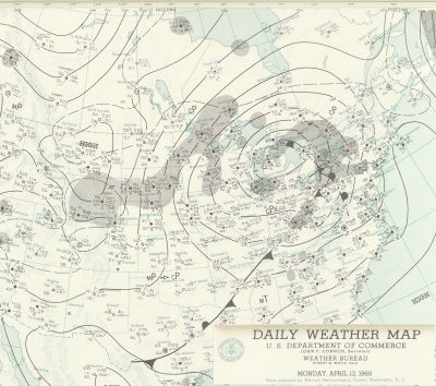
After a cold and stormy March around the Midwest and Great Lakes Basin, residents looked to early April for a warming trend. The Palm Sunday weekend had begun rather chilly as a large cold air mass slipped across the Great Lakes and Ohio Valley, but warm, moist tropical air moving into the region drove up temperatures as Sunday dawned. The 1 am (EST) weather map showed a weak low-pressure cell over western Iowa with a warm front extending across Iowa, northern Illinois and Indiana and a cold front poised southward over eastern Kansas.
Surface Weather Map for 11 April 1965 1 AM EST Courtesy: NOAA Central Library Data Imaging Project
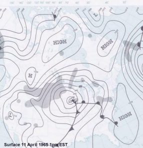
Surface Weather Map for 11 April 1965 1 PM EST Courtesy: NOAA Central Library Data Imaging Project
Twelve hours later, the low slipped eastward to central Iowa and began to deepen. The most striking feature of the synoptic situation as analyzed by Fujita, et al (1970, Monthly Weather Review) is the contrasts among the air masses. Pushing out the cold air from a departing anticyclone was a warm, moist tongue of Gulf air (maritime tropical mT). This air met moist, colder air (maritime polar mP) at the warm front. The warm air was being pushed at the cold front by a wedge of dry cold air (continental polar cP) across the Southern Plains. The temperature drop at the cold front was small compared to the drop in the dew point temperature. The jet stream, extending throughout all levels of the higher atmosphere, flowed out of the southwest just south of the surface low across the Iowa–Missouri border and traversed Lake Michigan over the Chicago area and then across the north shore of Lake Erie.
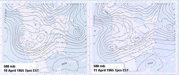
500 mb chart for 10 April 1965 7 PM EST (left) and 11 April 1965 7 PM EST (right) Courtesy: NOAA Central Library Data Imaging Project
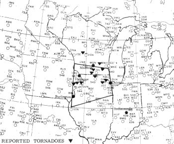
The volatile weather system began spawning thunderstorms across Iowa and western Illinois as the noon hour approached. The rapid change in the mid-morning prompted the Severe Local Storms Center (SELS) in Kansas City, Missouri to issue a Severe Weather Forecast for an area extending from northeastern Missouri to north central Indiana at 1045 CST. Further organization of the low pressure system and its movement rapidly northeast along with other indicator factors gave SELS forecasters concern that the danger zone was likely to be further north and northeast than first anticipated. A new Severe Weather Forecast, calling for severe thunderstorms, high winds, damaging hail and possible tornadoes are likely, was issued at 1300 (1 pm) CST. Note that in the 1960s, these forecasts were issued to the local Weather Bureau offices who then warned the public of any dangers. Also, this was the highest severity level forecast that could be issued by SELS. A tornado warning could not be issued until a tornado had been positively identified by either human sighting or a fairly positive identification by radar (which at the time were not as accurate as today's weather radars).
SEVERE WEATHER FORECAST NUMBER 68
ISSUED 100 PM CST APRIL 11, 1965
EXTREME SOUTHERN WISCONSIN
EXTREME EASTERN IOWA
PORTIONS OF NORTHERN ILLINOIS
A FEW SEVERE THUNDERSTORMS WITH LARGE HAIL DAMAGING WINDS AND ONE OR TWO TORNADOES ARE EXPECTED FROM 1 PM UNTIL 6 PM CST THIS SUNDAY AFTERNOON AND EVENING IN AN AREA BOUNDED BY THE POINTS 40 MILES SOUTH OF BURLINGTON IOWA TO 50 MILES WST OF LONE ROCK WISCONSIN TO MILWAUKEE WISCONSIN TO 40 MILES SOUTH EAST OF CHICAGO ILLINOIS BACK TO THE POINT 40 MILES SOUTH OF BURLINGTON IOWA.
WOOD ... 1906Z
SELS Severe Weather Forecast 68: Forecast Zone Source: US Weather Bureau Survey Team Report May 1965
This 1300 CST SELS Severe Weather Forecast was issued 15 minutes after the first tornadoes touched down in Iowa: one in Lowden and one in Clinton. A third would appear at Marquoketa, Iowa 45 minutes later. Tom Grazulis (Significant Tornadoes 1680-1991) would later report that the Lowden tornado, an F4, moved from outside Tipton to near Springbrook, striking 25 farms and destroying one completely. A Lowden man injured by the twister died a month later.
Between 1 and 4 pm, the Dubuque, Iowa Weather Office issued warning statements to residents of northwestern Illinois and southwestern Wisconsin, the first at 1:10 pm. The Peoria, IL office issued a tornado warning for areas north of the city at 1:06 pm. Chicago, Rockford IL, and Milwaukee offices issued public statements between 1 and 1:30 pm CST.
The second significant tornado in the emerging outbreak hit north northeast of Stockton IL at 2 pm and moved across the Wisconsin border and through Monroe WI. Rated an F1 by Grazulis in Illinois, it gave F2 damage to Monroe. Fifty businesses and 65 homes were destroyed or damaged there, and 40 were injured. Damages was estimated to be in the $4 million range.
Tornado Damage to Motel North of Monroe, Wisconsin Source: Fujita, et al, Monthly Weather Review, 1970
Two additional F2 tornadoes struck southwestern Wisconsin between 2 pm and 3 pm, causing mostly building damage. The first moved from southeast of Evansville to northwest of Ft Atkinson causing seven injuries to residents of mobile homes near Ft Atkinson. At least thirty farms lost one or more buildings. The second appeared over Crawford County, causing no injuries but destroyed a barn.
The outbreak region moved eastward to the eastern border region of northern Illinois and southern Wisconsin between 3 pm and 5 pm. At 3:20, a strong F3 twister moved 24 miles along a wide path near Watertown WI. Three deaths occurred when the storm struck cars travelling down US-16 near Piperville. Seven minutes later, the Crystal Lake tornado struck, resulting in $1.5 million in damage. Three minutes after, another F3 hit Como WI north of Lake Geneva. Before the hour was out, three more F2s hit doing property damage. One began as a waterspout over Druce Lake, damaging some homes between there and Gurnee, and flipped two planes at Waukegan Memorial Airport. The other struck to the north in Walworth County WI destroying a barn. The next struck Monroe County Wisconsin destroying farm buildings north of Tomah. Several other tornadoes were sighted during this time but were not rated "significant" (either F0 or F1).
The 13 tornadoes which struck this region caused 10 deaths, hundreds of injuries and millions in property damage. All but two hit within the forecast zone. The low pressure system and cold front were, by mid afternoon, speeding eastward at 50 mph. Above it, the jet stream had split into two currents and an new low was forming over northeastern Illinois.
But as the weather system sped eastward, the worst was yet to come. Ahead were the states of Indiana, Michigan and Ohio.
Reference material for this and the other two segments of this article was mostly taken from:
Fujita, et al, 1970: "Palm Sunday Tornadoes of April 11, 1965," Monthly Weather Review Volume 98, No 1, 1970. For pdf version, click here; Report of Palm Sunday Tornadoes of 1965: April 11, 1965 by US Weather Bureau Survey Team, 1965, US Weather Bureau, 64 pp;
Grazulis, T., 1993: Significant Tornadoes 1680-1991, Environmental Films, St Johnsbury VT;
Weather Bureau Survey Team, 1965: Report of Palm Sunday Tornadoes of 1965, April 11 1965. US Weather Bureau, Department of Commerce, Washington DC.
I also thank local Crystal Lake residents Jenni (Percy) Haas and Janet (Enright) Green, Chuck Scudder and Randy Heidorn for corrections and additional materials.
Learn More From These Relevant Books Chosen by The Weather Doctor
For More Weather Doctor articles, go to our Site Map.
I have recently added many of my lifetime collection of photographs and art works to an on-line shop where you can purchase notecards, posters, and greeting cards, etc. of my best images.