1965 Palm Sunday Tornado Outbreak Part II: Sunday Evening
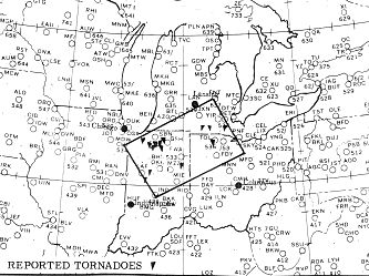
By 5 pm CST, two distinct low cells now were apparent on the weather charts: one over south central Wisconsin, the other over southwestern Michigan. The Severe Local Storms Center (SELS) had issued a Severe Weather Forecast for northwestern Indiana northeastward to southeastern Michigan and northwestern Ohio at 4:20 PM CST (5:20 EST).
SEVERE WEATHER FORECAST NUMBER 69
ISSUED 420 PM CST APRIL 11, 1965
PORTIONS OF NORTHERN INDIANA
PORTIONS OF SOUTHERN MICHIGAN
PORTIONS OF NORTHWEST OHIO
SCATTERED SEVERE THUNDERSTORMS WITH A TORNADO OR TWO LARGE HAIL AND LOCALLY DAMAGING WIND STORMS ARE EXPECTED IN AN AREA ALONG AND 60 MILES EITHER SIDE OF A LINE FROM 10 MILES NORTHWEST OF LAFAYETTE INDIANA TO DETROIT MICHIGAN FROM THE PRESENT TIME TIL 8 PM CST THIS SUNDAY EVENING.
TORNADO FORECAST NUMBER 66 IS CANCELLED
CRUMRINE .... 2230Z
SELS Severe Weather Forecast 69: Forecast Zone Source: US Weather Bureau Survey Team Report May 1965
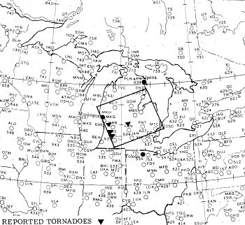
But they now saw a larger region in the threat zone. Therefore, at 6 PM, CST (7 pm EST), SELS issued a Severe Weather Forecast for most of lower Michigan.
SEVERE WEATHER FORECAST NUMBER 71
ISSUED 6 PM CST APRIL 11, 1965
PORTIONS OF CENTRAL MICHIGAN
SCATTERED SEVERE THUNDERSTORMS WITH A TORNADO OR TWO LARGE HAIL AND LOCALLY DAMAGING WIND STORMS ARE EXPECTED IN AN AREA ALONG AND 60 MILES EITHER SIDE OF A LINE FROM 20 MILES SOUTHEAST OF MUSKEGON MICHIGAN TO 60 MILES EAST OF GLADWIN MICHIGAN FROM THE PRESENT TIME TIL 8 PM CST THIS SUNDAY EVENING.
CRUMRINE .... 0009Z
SELS Severe Weather Forecast 71: Forecast Zone Source: US Weather Bureau Survey Team Report May 1965
With the ongoing reports of severe weather in Indiana and Michigan, SELS extended the forecast to a threat area from west central Indiana northeastward into western Ohio at 7:10 pm CST (8:10 pm EST).
SEVERE WEATHER FORECAST NUMBER 72
ISSUED 710 PM CST APRIL 11, 1965
PORTIONS OF INDIANA
THE NORTHWEST PORTION OF OHIO AND
PORTIONS OF SOUTHEAST MICHIGAN
SCATTERED SEVERE THUNDERSTORMS WITH A FEW TORNADOES LARGE HAIL DAMAGING WIND STORMS ARE EXPECTED IN AN AREA ALONG AND 60 MILES EITHER SIDE OF A LINE FROM 60 MILES SOUTHWEST OF INDIANAPOLIS INDIANA TO 20 MILES SOUTH OF DETROIT MICHIGAN FROM 8 PM TO MIDNIGHT CST THIS SUNDAY EVENING.
CRUMRINE
Indiana Twisters
The first tornado reported in Indiana touched down at around 5:30 pm EST at Hamlet in Starke County, then moved northeasterly though Koontz Lake, becoming a waterspout as it crossed the lake waters. It then demolished 30 cottages and damaged an additional 70 at Kootz Lake. This massive F4 storm killed 10 people and injured 82 as it rampaged across Starke, Marshall, St Joseph and Elkhart counties. This tornado continued its northeast trek toward La Paz, where six homes and a church were destroyed, and Lakeville, where it destroyed a high school under construction. The tornado then continued into Wyatt destroying twenty homes.
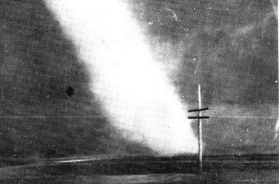
Tornado near Lapaz, Indiana, photo taken by Indiana State Trooper Robert Candler Source: Fujita, et al, Monthly Weather Review, 1970
This tornado gained some added infamy when Indiana State Trooper Robert Candler snapped a photograph of it near US-31 north of Lapaz. Because of the sun angle, the tornado appeared white against the dark cloud background.
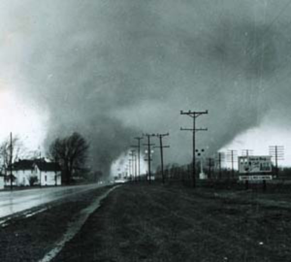
Tornado near Goshen, Indiana, photo taken by Elkhart Truth reporter Paul Huffman Source: Fujita, et al, Monthly Weather Review, 1970
The first of two F4 tornadoes to strike Elkhart County formed at 6:15 pm (EST) near Wakarusa in St. Joseph County where it killed a child. As it continued its destructive journey northeastward through Nappanee and Dunlap, Elkhart Truth reporter Paul Huffman shot a series of photographs outside Goshen which showed this tornado had a double funnel. It struck a trailer park between Elkhart and Goshen, destroying 80 of 100 units and killing ten. Three were also killed by this storm in Middlebury where many homes were levelled. In all, this tornado killed 14 and injured 200 along its 22-mile path. The storm produced one oddity here: a wing from an airplane in Goshen was found 35 miles (56 km) away in Centerville, Michigan.
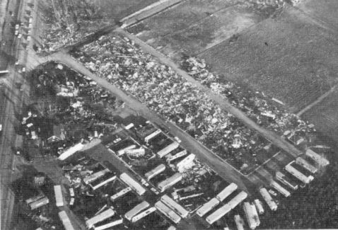
Tornado Damage to Midway Trailer Court near Goshen, Indiana Source: Fujita, et al, Monthly Weather Review, 1970
The second Elkhart F4 sprang up at 6:40 pm southeast of Goshen and moved to the vicinity of Brighton in LaGrange county. Nineteen died in this tornado, 17 in the Rainbow Lake and Shore areas where a dozen homes were demolished.
The third tornado of the day to move across Elkhart County first touched down in St Joseph County south of South Bend at 7:10 pm. As it grew to an F5 storm, this double-funnel twister began the deadliest rampage of any of the Indiana tornadoes this day. Thirty six died and 320 were injured as it levelled houses and a truck stop. Particularly, hard hit were housing tracts in Sunnyside and Kingston Heights, where 28 fatalities were registered.
Ten minutes after the first Elkhart tornado, a strong F3 tornado rolled across Porter/LaPorte counties from Morgan Township to past South Center, destroying homes and barns, but causing only 4 injuries.
The carnage was not yet over in Indiana, where a total of 137 would die, the highest death toll of the six states. Four additional tornadoes rated F4 would stampede across the northern half of the Hoosier State between 6 and 7 pm. Clinton County would see two of these. The first, actually a pair of tornadoes, arose in Steuben County and moved across the Michigan border and was not of great consequence in Indiana.
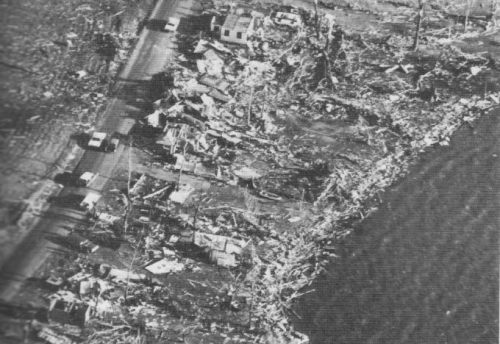
Tornado Damage along Eastern Shore of Lake Pleasant, Indiana Source: Fujita, et al, Monthly Weather Review, 1970
The second touched down in Tippecanoe County, southwest of Lafayette at 7:07 pm, destroying a few homes before moving into Clinton County. The 44 injured by this tornado were all residents of Clinton County where the storm did the most damage to buildings from Cambria to Moran.
At 7:20 pm, an F4 tornado cut a 45-mile (72 km) path across Montgomery, Boone and Hamilton Counties leaving 28 dead and 123 injured. Having touched down south of Crawfordsville, it took its first life destroying a home east of that community. It then cut a mile-wide swath past Lebanon demolishing 54 homes and killing 11, six in one family. Ten more died when the storm destroyed 25 homes near Sheridan, and four were killed when two cars were swept from a highway.
Minutes later (7:25 pm), another F4 wrote a similar story across Howard and Grant Counties. Moving from outside Russiaville to north of Arcana over a 47-mile (76 km) path, this tornado also killed 28, but injuries along its path increased to 835. The tornado damaged or destroyed over 90 percent of the buildings in Russiaville. Moving across Alto and southern Kokomo, one hundred homes plus the Maple Crest Apartments were demolished. The upper story walls and roofs of the brick apartment building were razed. And yet, according to Grazulis, this twister had not yet reached its greatest strength. That came at Greentown where 80 homes were flattened. Ten died here and debris from the homes destroyed was strewn across the countryside. The death toll in Howard County reached 18 and 600 were injured.
When the storm crossed into Grant County, it destroyed more homes south of Swayzee then south of Marion, the tornado was joined by a second funnel. They unroofed a VA hospital whose clock stopped at 8:10 pm, injuring 20, then knocked down the Panorama Shopping Center. South of Marion, they also toppled 31 transmission towers. The damage estimate in the Marion area alone amounted to $12 million. The twisters continued across Linn Grove at 8:40 pm causing extensive damage then touched the northern edge of Berne before crossing into Ohio at 8:52 pm.
The last significant tornado to strike Indiana touched down at 8:20 pm near Roll in Blackford County and did F4 damage at Keystone (Wells County) where two died. It then moved to Linn Grove in Adams County where two more died. The storm then moved into Ohio.
Michigan Tornadoes
Michigan suffered damage from multiple tornado strikes across the southern counties of the Lower Peninsula. In total, 53 would die in the Wolverine State that day.
The first significant tornado (F2 or greater) to touch down in Michigan was reported in Kalamazoo County at 6:40 pm (EST). The F3 storm took no lives as it moved from near Cooper Center to near Augusta, but 17 where injured as four homes were destroyed and 22 other buildings damaged.
The next strike began south of Allendale at 6:50 pm and then moved across northwestern Grand Rapids. Five died, all in Grand Rapids and 142 were injured along the 28-mile (45 km) swath. Thirty-four homes were destroyed and over 190 additional damaged, an estimated $15 million price tag.
At the same time, another, weaker tornado (F2) touched down further south in Allegan County. Moving from east of Burnips to north of Middleville, it destroyed a trailer killing its occupant. Five additional homes were destroyed with damage to an additional 25.
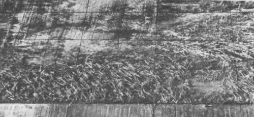
Tornado Tree Damage near Algansee, Michigan Source: Fujita, et al, Monthly Weather Review, 1970
Shortly after 7 pm, the first of two tornadoes to follow an almost identical path crossed the Indiana border near East Gilead in Branch County. The second appears to have formed about a half hour later (7:30 pm). Both began in Branch County, crossed Hillsdale and Lenawee counties and finally dissipated in Monroe County, a long eastward trek of 90 miles (145 km). Because of the closeness of these two twisters from near Kinderhook eastward, it was impossible for Fujita's team to distinguish which storm did which damage. Both were rated as F4. The combination was the deadliest of the Michigan Palm Sunday tornadoes, taking 44 lives and injuring 612.
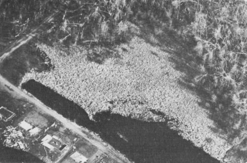
Tornado Debris Dumped in cove of Coldwater Lake, Michigan Source: Fujita, et al, Monthly Weather Review, 1970
The first tornado, which may have been the most intense, moved across the state line near Lake Pleasant (IN) and swept away dozens of home in Coldwater Lake, blowing much of the debris into the lake. The second first touched down southwest of Kinderhook and flattened a home north of Reading. The two paths merged five miles (8 km) west-southwest of Hillsdale. Branch County suffered the greatest death toll: 19 with 200 injuries. Monroe County tallied 13 dead. South of Hillsdale, the second tornado finished the destruction begun by the first. In the four counties over which these two F4 twisters rampaged, 44 people died and 612 sustained injury. The property damage was estimated at $32 million.
One tornado struck the Manitou Beach Baptist Church during Sunday evening services. Of the 50 attendees, 26 did not make it to the church's basement and were buried in the debris for up to two hours. One man died. About a hundred of the vacation cottages around the beach were demolished. Fortunately at this early date in the season, all were vacant, but damage amounted to $5 million. A home five miles (8 km) south of Manitou Beach was not so fortunate, in its destruction six members of the family died. In all the two tornadoes and accompanying microbursts destroyed about 200 homes in Branch County, 177 in Hillsdale County and 189 in Lenawee County. When the first tornado dissipated in Monroe County, it was nearly an hour ahead of the second.
Another F4 touched down in Clinton County south of DeWitt at 8:15 pm. It killed a nine-year-old girl in one home demolished by the tornadic winds. Several other nearby homes were severely damaged as were three in Shiawassee County. At the same time the second of the two above tornadoes formed, an F2 that destroyed barns and garages and damaged 15 homes began its 15-mile (25 km) trek across Barry and Eaton Counties, from northwest of Hastings to east of Woodland.
As darkness descended over southern Michigan, four more tornadoes would strike. The most severe, an F3, moved from near Crystal Lake in Montcalm County to near Alma in Gratiot County beginning at 8:25 EST. There was only one injury from this storm, but may farm buildings and livestock were destroyed.
No deaths were reported from the final three twisters in Michigan that day, each was rated an F2 and had paths of around 10 miles (16 km) in length. Each did property damage, destroying barns, trailers, and an auto dealership, unroofing a library in Alma, and destroying a lumberyard in Unionville as well as unroofing their firehall.
Two touched down at 8:50 pm. One moved southeast from near Vestaburg in Montcalm County to near Alma in Gratiot County. The other hit Portsmouth Township in Bay County, the northernmost of the day's tornado outbreak. The final Michigan tornado hit at 9 pm southwest of Unionville and moved from there into town, doing property damage to the firehall and to barns and a lumberyard outside town.
As the intense thunderstorms rolled eastward ahead of the low pressure cell and cold front, Detroit was hit with heavy rain rather than tornadoes. Both Detroit City and Metropolitan Airports received about 1.5 inches (38 mm) of rain. While Michigan was finished with tornadoes, the outbreak had yet not exhausted its energy, and our eyes now turn south to Ohio.
For More Weather Doctor articles, go to our Site Map.
I have recently added many of my lifetime collection of photographs and art works to an on-line shop where you can purchase notecards, posters, and greeting cards, etc. of my best images.