| Home | Welcome | What's New | Site Map | Glossary | Weather Doctor Amazon Store | Book Store | Accolades | Email Us |
 | |||||||||
The Other Side of the Mountain: RainshadowsPreviously, I have written about gap winds, winds that accelerate as they push between high topographical features. This month, I'll take a look at one consequence when those winds that flow over high mountain ridges instead: the rainshadow. Through most of this article, I will refer to my home territory in the Pacific Northwest where the rainshadow effect is especially expressed, but rainshadows can be found on the lee of most mountain ranges and high individual peaks, such as the volcanic peaks that make up the Hawaiian Island chain. (In the temperate zone of the Northern Hemisphere, the rainshadow is usually, but not always, found along the eastern slopes of the ranges because the prevailing winds are westerly.) The process starts on the windward side of the range where moist air is forced to rise over the mountain ridges. In the ascent, the air cools and its moisture condenses, forming extensive clouds and rain/snow. When ranges are high, like the coastal of western North America, much of the moisture in the air falls out on the windward slope. In the Pacific Northwest, this provides the conditions for the extensive temperate rainforests for which the region is known. After crossing the ridge lines, the moisture-depleted air begins to descend and, in the descent, warms through compression. The downward motion has two effects on the air mass. First, by warming, the air re-evaporates a good portion of the liquid moisture remaining as raindrops/snowflakes and clouds. Second, the downward flow inhibits the formation of thick, precipitation-rich clouds, and thus the potential for precipitation decreases. The region of descending air and decreased precipitation is what we term the rainshadow. 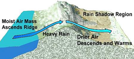 Rainfall Variations over a Mountain RangeWhere rainshadows regularly form, the differences in precipitation can be extreme over rather short distances, in places a factor of ten in annual precipitation over a hundred kilometres or so. Some examples from the Pacific Northwest point this out ably. Spokane, in Washington's eastern arid zone received less than half of Seattle's annual precipitation total (16.7 inches (420 mm) to 37.1 inches (942 mm)); Kamloops in interior British Columbia receives less than a quarter of Vancouver's precipitation (279 mm (11.0 inches) to 1199 mm (47.2 inches)). Storm systems moving out of the Gulf of Alaska (see Gulf of Alaska Storms) push moist air along the western American coast from southern Alaska through British Columbia and down into Washington and Oregon and northern California. The air not only meets the coastal mountains but several parallel ranges before reaching the plains and prairies of the central continental interior. Each range robs the air of a little more moisture, producing arid conditions east of the ranges. On the eastern slopes of this great continental backbone, moisture occasionally flows upward from the Gulf of Mexico in the currents and eddies of storm systems formed off the Rockies, but this eastern moist air is swimming upstream and does not provide the level of moisture seen on the opposite coast in the piedmont reaches of the Appalachian and associated mountain ranges where no rainshadows are found. As a result, each western range has a rainy (relatively) western slope and a rainshadow along the eastern slope, with the total precipitation accumulated declining with each successive ridge crossing. The accompanying figure shows the impact of mountain ranges from the Pacific shores to the prairies of Alberta across British Columbia, but similar effects can be seen in American regions as well. 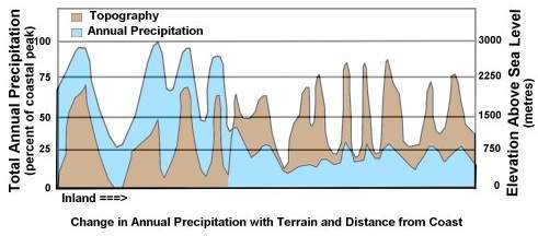 Precipitation Variation with inland distanceThe composite result across the continent is manifest with a band of desert and near-desert conditions that extends from the lee of the Sierra Nevada Mountains in Mexico and Arizona northward into southern British Columbia. In fact, a pocket desert can be found tucked in British Columbia behind the Cascade Range. On the regional scale, the rainshadow impact is quite noticeable on southern Vancouver Island when annual precipitation twenty to thirty kilometres west of downtown Victoria are typically greater than 2000 mm (78.7 inches) while a few kilometres east of the central core, the total is less than 700 mm (27.6 inches). This rainshadow is centred on the Georgian Basin, that body of water that separates Washington, Vancouver Island and mainland British Columbia. The following figure shows the impact on summer rainfall totals. 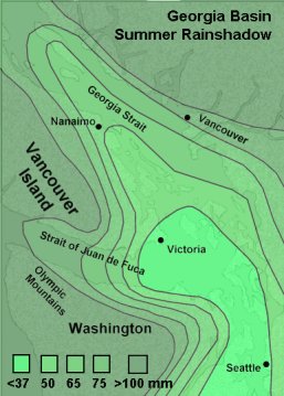 Georgia Basin RainshadowLearn More From These Relevant Books
|
|||||||||
 |
To Purchase Notecard, |
Now Available! Order Today! | |
 |
 |
NEW! Now Available in the US! |
The BC Weather Book: |


