| Home | Welcome | What's New | Site Map | Glossary | Weather Doctor Amazon Store | Book Store | Accolades | Email Us |
 | |||||||||
Gulf of Alaska StormsAs summer wanes and the sun's influence on high Northern Hemisphere latitudes diminishes, the prime global breeding grounds for northern winter storms renew their vigour. One can be found in the North Atlantic Ocean between the coasts of Greenland and Iceland, the appropriately named Icelandic Low. The second lies in the North Pacific off the coast of Alaska between the Aleutian Islands archipelago and the southern Alaska coast. It goes by the names the Aleutian Low and the Gulf of Alaska Low. These low pressure zones are semipermanent features of the global weather map and general circulation patterns that diminish in extent and depth during the warm season and intensify during the cold months. 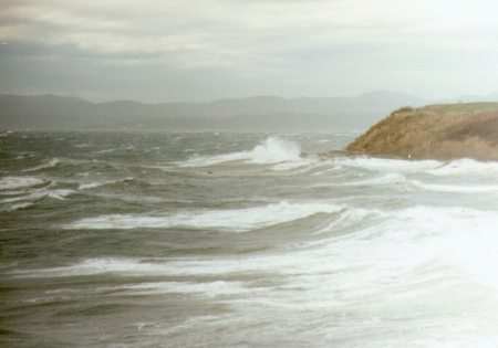 The Aleutian Low and the eastern North Pacific High found to the south have a cyclic relationship during the course of the year which impacts the weather along the west coasts of Canada and the United States and into the northern portions of the western Cordilleran. Since this is also a prime source region for Pacific maritime air masses, the weather patterns across the continent are also affected. Within the subpolar zone, warm air moving north from the tropics and cold air moving south from the Arctic clash, a conflict that is strongest during the cold half of the year and weakest during the warm season months. After an active winter, the Aleutian Low diminishes slightly in March and by April is sending fewer storms outward. The feature virtually disappears in July, appearing as a trough of low pressure rather than a tight low-pressure cell. As solar energy falling on the arctic regions diminishes, the Aleutian Low again strengthens in September, ready to produce a litter of winter storms. The clash between cold and mild air generates spinning, low-pressure cells that grow to energetic youth over the Gulf of Alaska. As a result, meteorologists call the region a "center of action" for North Pacific maritime and coastal storms. The Aleutian Low region is characterized by barometric pressure readings of 101.3 kPa or less, high humidity, and generally complete cloud covers. When a newly born storm spins up, the region experiences strong winds and heavy precipitation, most falling as rain, despite the high latitude. By November, the Aleutian Low average surface pressure has dropped to 100.2 kPa, a level it maintains for much of the winter. The Gulf of Alaska lies in the arched bite of the State, south of Anchorage between the Kenai Peninsula and Kodiak Island and the eastern panhandle. The northern coast of the gulf is fortressed by the Wrangell/St Elias Mountains � one of the world's highest mountain ranges which continues to grow at a geologically-hyper speed of 4 cm (1.6 inches) per year — that effectively block most storms from entering eastern Alaska and the Yukon Territory. The Gulf of Alaska is the most common entry point for the northeastern Pacific storm track that sends stormy weather to the North American coast. 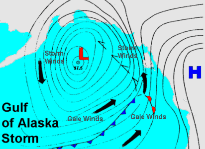 Storms move out of the Gulf of Alaska into the Pacific Northwest region of the continent with great regularity, as many as three or four per week during the height of the winter storm season. Quite often, these storms are packed so closely that the Pacific Northwest does not experience the clearing weather break so common over the rest of the continent. I have compared this train of tempests to the roll of a nearly never-ending freight train of nearly uniform boxcars. As each storm rolls by, the clearing break is often no more than a tease, like the daylight seen between the roll of a chain of boxcars. Only rarely in some areas of the coast does a "flat car" appear and the "caboose" may not arrive until spring. Winter Gulf of Alaska storms typically sport winds in excess of 80 km/h (50 mph) with corresponding high waves. Some storms rival the strength of the great hurricanes/typhoons and would be considered as such if their origins were tropical rather than polar. (In fact, the Hurricane Hunter air squadron often deploys aircraft into these storms to study their structure.) Winds as high as 160 km/h (100 mph) have been recorded with wave heights pushing 20 m (65 ft) or more. Over the years, these storms have taken their toll of fishing and merchant vessels caught in open waters. When these storms hit the North American coast, they encounter a series of high mountain ranges parallelling the coast from central Alaska southward into California. The mountains force the storm air to great altitudes causing then to dump much of their prodigious moisture content on the coastal mountains as rain and snow. The result is the incredibly dense temperate rainforests that cover the coast from Alaska's Panhandle through British Columbia and into northern California. 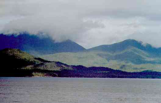 In these regions, rain and snow are measured in metres (yards) annually. During the winter, nearly all days report rain or snow somewhere in the region. The wetness sits in the region can be exemplified by Juneau, Alaska — 222 wet days annually; Prince Rupert, British Columbia — 240; Clearwater, Washington — 192; and Astoria, Oregon — 190. The world's record for snowfall in one snow year (which runs from July 1-June 30) was established on Mt Baker in Washington in 1998-99: 2986 cm (1140.0 inches). And North America's wettest year drenched Montague Island's MacLeod Harbor, about 112 km (70 miles) east of Seward, Alaska with 8440 mm (332.29 inches) in 1976. Learn More From These Relevant Books
|
|||||||||
 |
To Purchase Notecard, |
Now Available! Order Today! | |
 |
 |
NEW! Now Available in the US! |
The BC Weather Book: |


