| Home | Welcome | What's New | Site Map | Glossary | Weather Doctor Amazon Store | Book Store | Accolades | Email Us |
 | |||||||||
Gap WindsTerrain interacts with the atmosphere in many ways to alter the weather situation, for example, presenting various angled slopes that differ in the surface absorption of sunlight and thus the heating of the air. On all scales, from the global circulations to the microscale, topography's interaction with the wind produces special flow situations. Winds flowing up mountain slopes often form clouds at higher elevations where the air's moisture may drop as rain or snow. When that flow crosses the summits and flows down the descending slope, its compression produces the warm and dry chinook and Santa Ana winds. If winds push through the terrain in spots, rather than going over it, another set of wind phenomena arises, the gap winds. 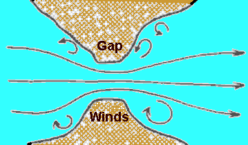 Gap Winds Flow SchematicGap winds are low-elevation winds associated with gaps or low elevation areas in mountainous terrain, including flow through valleys and canyons and among peaks. These wind fields arise in terrain gaps ranging from hundreds of metres to hundreds of kilometres wide and produce local increases in speed and often large changes in wind direction that more or less parallel the gap axis. Gap winds typically blow over shallow depths that do not exceed a kilometre and are often only a few hundred metres deep. (A special form of gap wind blows in urban areas, the street canyon wind, caused by gaps between buildings rather than terrain.) Gap winds are strongest when a large pressure gradient exists across the gap, although some gap winds do not depend on the large-scale pressure gradient but on the wind entering the gap. 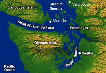 My home on southern Vancouver Island sports one of the most well-known gap winds on the continent when strong, low-level winds blow through the Strait of Juan de Fuca between the Olympic Mountains of western Washington State and the Insular Mountains of Vancouver Island. These winds can be especially hazardous to sailors and boaters on the strait because they can arise swiftly under seemingly benign weather conditions, raising small-craft warnings and at times gale warnings while surrounding waters have no warnings or lesser warnings. 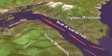 When winds blowing from the wide-open Pacific Ocean meet the topography of the rugged western North American coast, the high terrain places an impediment in the path of the flow. Usually, the winds are deflected upward to cross over the mountain ridges. Where gaps such as the Strait of Juan de Fuca occur, however, the surface winds converge on the opening in order to pass through the sea-level route. Just as a crowd trying to push through a small door or gate exerts pressure on those near the opening, forcing them to move quickly through, the moving air molecules increase the pressure gradient at the Strait's entrance, causing the wind speed to increase within the gap. For years, gap winds have been explained using the familiar engineering analogy of the Venturi effect in which the flow of a fluid increases as it flows through a tapered tube or nozzle, peaking at the point of tightest constriction. Meteorologists now know this is not the complete story nor always the correct one for gap winds. Part of the reason the venturi effect analogy is not strictly correct (though in narrow gaps, it can be a good approximation) is that, unlike the tube or nozzle of the engineer's venturi, the terrain gap is not a fully enclosed space but a channel with an open top, that is, no rigid upper lid restricts the flow to two-dimensions. As a result, the pressure build-up due to convergence of the wind flow at the entrance not only pushes the air through the terrain gap but forces some air to rise over it. As a result, meteorologists find the strongest winds blow not at the narrowest width of the gap but near its downwind "re-opening." The nature of the terrain flow is also usually more complex as it enters the gap than in the simple venturi and this plays a role in defining the resulting gap wind. And finally, the larger synoptic-scale pressure gradients that produce the overriding wind field have spatial variations that also have influences. (For more detailed discussions of the physics involved, see COMET Program Mesoscale Primer: Gap Winds at http://meted.ucar.edu/mesoprim/gapwinds/.) Given that, in simplistic terms, gap winds are caused by wind trying to force its way through terrain gaps, why can conditions change so drastically in locations like the Strait of Juan de Fuca for mariners, particularly during a otherwise peaceful spring or summer afternoon? The answer is a sea-breeze flow regime superimposed on the restrictive topography. On a sunny spring/summer day in the Pacific Northwest, the morning dawns with air temperatures over the ocean waters and inland fairly similar. As this day proceeds, however, the strong seasonal sun heats the air east of the coastal mountains to temperatures that may exceed 37.8 oC (100 oF). This heating reduces the density of the overland air, causing it to rise, and forms a temporary region of low pressure by mid- to late afternoon (known as a thermal low). In contrast, the air over the Pacific Ocean waters remain at a temperature much cooler than those inland. As a result of this increasing temperature differential, the surface pressure is relatively higher over the ocean than overland, and thus, sea air begins to flow inland. This thermally induced regional air flow is known as the sea breeze. The strength of the sea breeze is dependent in part on the thermal contrast between land and sea, which increases until the sun ceases to heat the land. 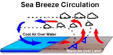 In a flat coastal area such as Florida, the sea breeze brings air in more or less uniformly. But on the rugged Pacific Northwest Coast, the coastal mountains present a barrier to such a simple flow regime. Some air rises up the windward slopes forming clouds above the summits. But in gap areas such as the Strait of Juan de Fuca, the sea breeze can rush through the confluence zone, increasing in speed as the day progresses. The resulting gap winds not only are stronger than open water winds, they also raise surface waves and interact with tidal currents to pose additional hazards for those on the waters. Similar gap wind effects are found around the world where shoreline topography interacts with the wind, often providing outlets for winds pushing out of the mountains during the winter. British Columbia's coastal arctic outflow winds and the gorge winds flowing down the Columbia River gorge are additional examples of these winds. 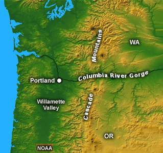 Learn More From These Relevant Books
|
|||||||||
 |
To Purchase Notecard, |
Now Available! Order Today! | |
 |
 |
NEW! Now Available in the US! |
The BC Weather Book: |


