Among the most commonly recognized weather features are the roaming regions of high and low pressure, designated by H's and L's on media weather maps, respectively.
Both Highs and Lows are actually very complex, three-dimensional elements so before I begin, I need to clarify a few things. When I write herein about Highs and Lows, I refer to the sea-level features as plotted on a standard surface weather map, and for the most part I will consider them as quasi-two-dimensional elements.
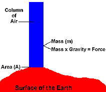
When we ascend in the atmosphere, whether starting in the centre of a High or a Low or anywhere in between, the absolute air pressure decreases because less atmosphere remains above to press down on us. That is why we must discuss the pressure field of surface highs and lows as sea-level pressure. If we did not correct the surface readings for their elevation above sea level, weather maps would be chaotic and give little enlightenment as to the state of the weather. For example, Denver would have a perpetual low pressure region around it compared to Los Angeles or Toronto or New York City. Thus, unless otherwise stated, when I speak of pressure, I mean sea-level pressure.
Perhaps surprisingly, given the high attention paid to Highs and Lows, the absolute difference in surface air pressure between the two is only about 10 percent of the total atmospheric surface pressure. Even the greatest extremes of sea-level pressure observed are less than 10 percent above or below the average sea-level value for the Earth.
High Pressure: A Bearer of Fair Weather
Let's start with the High pressure cell, in part because I discussed air masses in a previous article, and well-developed high pressure cells are these air masses. Highs are characterized by sinking air at their centre and mostly precipitation-free, clear skies. The highest pressure is found at it central core and pressure decreases outward.
In the centre of the high pressure region, the air is descending. When it reaches the impenetrable surface, there is a temporary build-up of air before it can flow away from the High's central core. This added mass exerts a higher weight � or force � on the surface below. Since pressure is defined as a force exerted over an area, the force of the additional mass results in a relatively high, central-pressure zone.
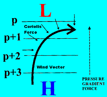
As a result of this, a pressure gradient (the change of pressure with horizontal distance), pushes air away from the centre toward the edges. If the Earth did not rotate, this wind would blow directly outward. But the planet does spin, and this affects the air's trajectory, an influence we call the Coriolis force or Coriolis effect, which is "strongest" as we move toward the polar regions and "weakest" in equatorial latitudes.
In the Northern Hemisphere, the Coriolis effect causes the wind to turn to the right (to the left in the Southern Hemisphere) as it blows over the earth. Thus, in the ideal situation, winds would circle the high pressure cell in a clockwise manner (known as anticyclonic because it is opposite in direction to flow around a cyclone/low pressure cell) as the Coriolis force balances the pressure gradient force (known as geostrophic flow).
Over the oceans and flat land areas (mountains are great complicators of weather patterns), this balance holds quite well above the surface layer. Within the surface layer, however, friction also plays a role by slightly altering the balance of pressure gradient and Coriolis forces to establish a new balance known as gradient flow. Gradient flow winds cross the pressure gradient (seen as isobars on a weather map) such that the air flows out from the high pressure cell.
Following formation, most Highs are generally elliptical in shape, and often large and sprawling. But as they interact with other air masses and topography, and are distorted by forces of the upper atmosphere, high pressure cells often become long and narrow in shape. When plotted on a surface weather map, these elongated pressure patterns resemble mountain ridges on terrain maps. Meteorologists therefore refer to them as high pressure ridges or simply ridges.
Because the air in a High sinks through a deep layer of atmosphere, the formation of clouds and precipitation are greatly inhibited. Generally if clouds do form, they are spawned by strong solar heating of the surface and are small and of limited vertical extent � usually fair weather cumulus (cumulus humilis). If the air of the High is humid and very warm, such as found in tropical air masses, and solar heating is strong, isolated, weak, isolated showers may form within the High, usually along the cell's outer edges. Otherwise, unless topography throws a "wild card" into play, high pressure regions are generally precipitation free.
In a companion piece, I look into Low Pressure systems, a quite opposite element.
Learn More From These Relevant Books Chosen by The Weather Doctor
Written by Keith C. Heidorn, PhD, THE WEATHER DOCTOR,
November 1, 2005 A version of this material was previously published by Keith Heidorn on Suite 101: Science of the Sky, 2002
For More Weather Doctor articles, go to our Site Map.
I have recently added many of my lifetime collection of photographs and art works to an on-line shop where you can purchase notecards, posters, and greeting cards, etc. of my best images.


 When we ascend in the atmosphere, whether starting in the centre of a High or a Low or anywhere in between, the absolute air pressure decreases because less atmosphere remains above to press down on us. That is why we must discuss the pressure field of surface highs and lows as sea-level pressure. If we did not correct the surface readings for their elevation above sea level, weather maps would be chaotic and give little enlightenment as to the state of the weather. For example, Denver would have a perpetual low pressure region around it compared to Los Angeles or Toronto or New York City. Thus, unless otherwise stated, when I speak of pressure, I mean sea-level pressure.