| Home | Welcome | What's New | Site Map | Glossary | Weather Doctor Amazon Store | Book Store | Accolades | Email Us |
 | ||||||||||||||||||||||||||||||||||||
Air Masses: A Base for Weather AnalysisLong before meteorologists began drawing fronts and cells of high and low pressure on national/international maps, those attuned to the skies understood that different masses of air had different, distinguishing properties. For example, around 400 BC, Hippocrates wrote in On Airs, Waters, and Places that health could be tied to the source of the winds flowing into the city. While his linkages between weather and health do not all hold today, this work showed an understanding of the differences between the properties of air flowing from different regions. 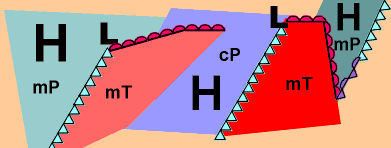 Until the 17th Century, early weather observers and folk forecasters used their senses to distinguish differences between air masses. Humans likely first recognized differences between air masses in prehistoric times when they sensed that changes in weather conditions had recognizable, repeatable patterns and common sensual properties: hot or cold, damp or dry. Good weather forecasters can build a forecast on a solid knowledge of the properties of the various air masses around their forecast zone in much the same way a wine taster can "forecast" the popularity of a good wine vintage. Since the air masses of concern often are hundreds or thousands of kilometres away, the weather forecasters must rely on a variety of measurements (such as temperature and humidity) to tell them of the "taste" and "bouquet" and "colour" of the various air masses. When I wrote a poem called "A Fine Vintage" several years ago, I took the concept of air mass analysis and used the metaphor of wine tasting to describe different types of airs. In it, I described how our senses of smell and sight, and at times taste, can distinguish the type, origin and travels of the air surrounding me at any given moment. Air Masses DefinedAn air mass by definition is a large dome of air which has similar horizontal temperature and moisture characteristics. As well, air masses often have a rather homogeneous temperature lapse rate above the influence of the surface layer. At any given time, an estimated fifty distinct air masses are scattered across the face of the planet. Some are newly born entities and strongly reflect their birthing ground. Others are old and travel-scarred with only the smallest commonality with their place of origin remaining. Distinctly different air masses are separated by narrow transition zones that weather analysts distinguish by drawing weather fronts -- warm, cold, stationary and occluded fronts -- between them. Sometimes these fronts indicate such subtle transitions, --perhaps only a shift in wind direction -- that they are hardly noticed as they pass. Others are vigorous zones where conflicts between warm and cold air masses produce very heavy weather -- severe thunderstorms or heavy snow. Often, the conflict between air masses is so intense that great cyclonic weather systems develop along the frontal boundary to lash the surface beneath with high winds, rapidly changing temperatures and precipitation of all varieties. No wonder the Norwegian meteorologists who first developed the concept of air mass analysis and their frontal boundaries used terms from warfare to describe the situation. The differences among air masses was likely first recognized when humans realized that major changes in weather had recognizable, repeatable patterns: e.g., cold, dry conditions come from the north; hot and dry or hot and humid weather from the south. But, until the 17th Century, the early meteorologists, like our wine tasters, had to use their senses to distinguish difference between them. In that century, the invention of instruments, such as the thermometer, barometer and hygrometer, allowed observers to measure objective properties of the air. With the advent of regular weather observations across large regions of the continents and weather/climate records from locations around the globe, meteorologists began to see repeatable patterns that showed large bodies of air could be distinguished by their temperature and humidity levels. The first formal theory of the impact of air mass differences came out of the famed Bergen (Norway) School of Meteorology during the early decades of the 1900s. Led by Vilhelm Bjerknes, the research group, which included his son Jacob, Halvor Solberg and Tor Bergeron, laid the foundation for modern weather analysis and forecasting. The group developed the concepts of frontal analysis, wave cyclone formation and air mass analysis to name but a few of their achievements. For our discussion, the significant finding was contained in Bergeron's 1928 dissertation. There he confirmed that certain characteristics of air masses did not substantially change or "age" for long periods of time as the air mass flowed over oceans and continents. Therefore, Bergeron concluded, knowledge of these characteristics was fundamentally important to improving weather forecasts. Bergeron saw air masses as being of four types: equatorial, tropical, polar and arctic (or antarctic). From this, he developed an elaborate classification scheme which included distinguishing properties of temperature, humidity and aerosol content (as measured by visibility). With slight modifications, his classification system remains a viable concept today in weather analysis and forecasting. Air Mass ClassificationAs I write this essay, approximately fifty distinct air masses can be identified globally in the lower atmosphere. Most cover thousands of square kilometres of surface and extend several kilometres vertically. Each one bears the mark of the region in which it was formed. Some of the fifty are young and fresh. Others are old and greatly transformed. Some are moving across the planet at speeds covering several hundred kilometres each day, others are nearly stationary. Air masses acquire their characteristic temperature and moisture (or absolute humidity) signature from the source regions over which they are born. The ideal source region is one with light winds, particularly in the upper atmosphere so that the air mass remains in place long enough to acquire the temperature and moisture properties of the underlying surface throughout the air mass. Therefore, middle latitude regions where the weather systems move quickly across their surface, driven by fast-moving upper level air currents such as the jet stream are not good air mass breeding grounds. At varied intervals, portions of these semi-permanent high pressure cells break away to form vagabond air masses that hitch a ride on strong upper air currents and travel the globe. Areas dominated by extensive areas of high pressure and light winds are the ideal breeding grounds for air masses. There are several such regions of extensive, semi-permanent high pressure around the globe, in particular, two latitude belts in each hemisphere: one in the polar regions, the other in the subtropics. 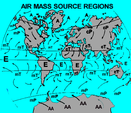 High polar latitudes and the subtropics around 30 degrees latitude are both good source regions, whose relative strength waxes and wanes with the solar seasons. Open ocean expanses, large deserts and extensive continental plains at high or low latitudes are the ideal birthing grounds within these belts. Mountainous areas are too variable in their properties, and mid-latitude continental plains are not conducive to air masses staying in place for long because of the strength of the prevailing westerly global winds at these latitudes. Mid-latitude oceans can be source regions under certain conditions because their surfaces have very uniform characteristics. From the characteristic properties picked up in their breeding ground, air masses are designated as hot or cold, wet or dry. The terms are to some degree relative. A cold air mass in summer may be as warm as a warm air mass in winter. Each air mass has a characteristic temperature and moisture content and thus we can distinguish four combinations: hot and dry; hot and wet; cold and wet; and cold and dry. Bergeron actually gave us two additional temperature categories by defining "very hot" and "frigid" air masses for those forming over the equator and polar regions, respectively. Wet air masses are consider to be air masses forming over the oceans, and dry air masses, those forming over the continents. Equatorial air masses are all considered to be wet because much of the land area under the equatorial zone is covered in tropical rainforests that can add as much moisture to the air as the equatorial oceans. All arctic (or antarctic in the Southern Hemisphere) are considered dry because there is little evaporation into them from the frigid polar oceans and their temperatures are so low that even at saturation, the absolute humidity is very low. The first dimension of the Bergeron classification system is the latitude zone of air source region which governs the air mass's temperature characteristics. There are four such zones in the system:
The letter in parentheses is that used to label air masses on weather maps. Next, are the two underlying surface characteristics of the source region that affect the resulting air masses:
The combination of the above gives us eight air mass types, but because Arctic (Antarctic) and Equatorial air masses only have one moisture character, we are left with the six basic air mass types given below:
On some weather maps, the lowercase letter "k" or "w" may be attached to the two-letter abbreviation describing an air mass. The "k" indicates that the air moving across a region is colder than the land surface temperature. while "w" indicates that the air is warmer than the land surface temperature. Thus, cold continental polar air flowing over warmer land surfaces would be designated as cPk. Air Masses Affecting Canada and the United StatesFive of the six basic air masses types affect weather in Canada and the contiguous United States. They can bring anything from scorching heat to bone-chilling cold depending on the type of air mass and time of year. The most violent weather usually occurs during Spring when cold, dry continental polar air clashes with hot, humid maritime tropical air. Arctic (A): Extremely cold temperatures and very little moisture typify Arctic air masses. They usually originate north of the Arctic Circle, where winter days of 24-hour darkness allow the air to chill to extremely low temperatures. Such air masses break southward across Canada and the USA during winter, but very are rarely seen at lower latitudes during the summer because the 24-hour sun warms the Arctic region considerably and the polar front and accompanying jet stream generally remains at higher latitudes. Continental polar (cP): Cold and dry, Continental polar masses are not as cold as Arctic air masses. These usually form further south in the subpolar Canadian North and Alaska and often dominate the weather picture across the continent during winter. Continental polar masses do form during the summer, but mostly influence only Canada and the northern USA. These air masses are usually responsible for bringing clear and pleasant weather during the summer. Maritime polar (mP): Cool and moist conditions characterize Maritime polar air masses. They usually bring cloudy, damp weather. Maritime polar air masses form over the northern Pacific and the northern Atlantic Oceans. These generally influence the Pacific Northwest and the Northeast, respectively. Maritime polar air masses can form any time of the year and are usually not as cold as continental polar air masses in winter because of the moderating influence of the sea surface beneath them. 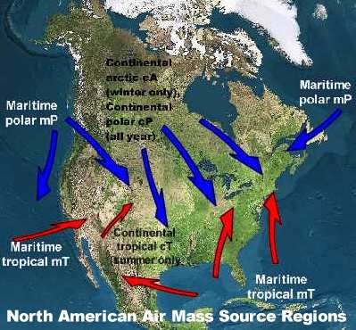 Maritime tropical (mT): Warm temperatures with copious moisture typify Maritime tropical air masses. They are most common across the eastern US and southeastern Canada originating over the warm waters of the southern Atlantic Ocean, Caribbean Sea and the Gulf of Mexico. These air masses can form year round, but they are most prevalent during summer. Maritime tropical air masses are responsible for the hot, humid days of summer across much of the eastern half of the continent. Such air masses are often called the Bermuda High because of their birthplace within the subtropical zone around and east of Bermuda. Continental Tropical (cT): Hot and very dry, Continental tropical air masses usually form over the Desert Southwest and northern Mexico during summer, often keeping the region scorching above 38o Celsius (100o Fahrenheit) during summer. They can bring record heat to the US Plains and the Mississippi Valley during summer, but they usually do not make it to the eastern and southeast US or into Canada as cT air masses. As they move eastward, moisture evaporates into the air, transforming the air mass to become more like a maritime tropical air mass. Continental tropical air masses very rarely form during winter. Equatorial (E) air masses, the remaining category, rarely visit the contiguous United States and almost never reach Canada, but these air masses are an important weather factors for the southern nations of North America: southern Mexico, Central America and many of the Atlantic island nations. See also: Another Fine Vintage and A Fine Vintage, a poem on Air Masses Learn More From These Relevant Books
|
||||||||||||||||||||||||||||||||||||
 |
To Purchase Notecard, |
Now Available! Order Today! | |
 |
 |
NEW! Now Available in the US! |
The BC Weather Book: |


