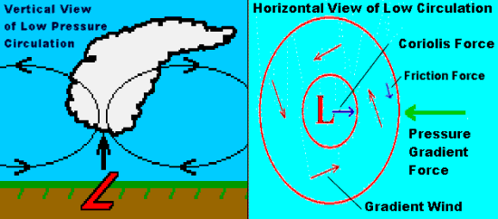
Low pressure cells or Lows are characterized in many ways beyond the obvious pressure difference in direct opposition to the High discussed in Part 1. A low pressure cell is characterized by converging air flow at the surface, ascending air currents at its core where the converging currents meet, and regions of divergent air flow above where air currents flow away from the rising core. When the combination of these processes removes air faster from the surface than it can be replaced by the converging inflow, the temporary mass deficit in the air column lowers its weight, and thus reduces the surface pressure, causing it to become lower than the surrounding atmosphere.
To replace the ascending air at the Low's core, surface air must flow inward toward the cell's centre. But as with the circulation in a high pressure cell, the Coriolis effect prevents a direct route. Thus, a geostrophic balance around a low pressure cell produces a wind field that flows around the Low in a counterclockwise direction in the Northern Hemisphere. This we call cyclonic flow. When surface friction affects the flow, the resulting gradient wind has an inward component toward lowest pressure.
Low pressure cells that travel long distances across the earth are called cyclones, or storm systems due to their attendant stormy weather. When a quasi-circular region of low pressure elongates to a long and narrow band, it is referred to as a low pressure trough or just a trough (as opposed to a high pressure ridge) by weather analysts.
Ascending currents within a Low push surface air toward higher altitudes. Air moving upward cools by expansion, usually reaching its condensation level along the way. Clouds form at the condensation level and extend upward in the atmosphere. If conditions are right, precipitation develops as more and more water vapour is transformed to larger liquid water or ice crystals that eventually fall earthward. Thus, the presence or approach of a low pressure cell signals cloudy and wet weather.
Preferred Locations For Low Formation
The formation of a low pressure cell, called cyclogenesis, can be a complicated process. Some lows form in specific geographical locations. Others form through the clash of contrasting polar and tropical air masses and influence of high speed air currents aloft that start a twist in the mobile polar front zone between the air masses.
The leeward sides of mountains are a common low pressure spawning ground. Over North America, cold-season storms such as the Colorado Lows and Alberta Clippers emerge from the lee of the Rocky Mountain chain. During the summer above desert regions, extreme solar heating may form large, quasi-stationary thermal lows.
Large bodies of water, such as the Great Lakes, can be breeding grounds for low pressure systems, or assist in the further development of weak lows moving over them. Cyclogenesis over water occurs when the water mass is significantly warmer than the air passing over. By imparting heat into the system from the warm waters below, updrafts are formed that start the development process. Over the Great Lakes, particularly Superior and Huron, the autumn is the peak season for low formation.
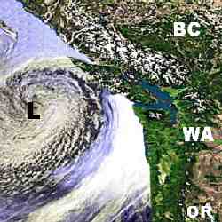
There are also several cyclone spawning regions around the globe. One, the Aleutian Low off Alaska, spawns the storms that worry North America's northwestern coast each winter. Its counterpart off Iceland sends storms into northern Europe. Tropical regions too have preferred locations that produce tropical storms, hurricanes and typhoons during specific periods of the year. In the Atlantic Ocean, areas west of the Azores and in the Gulf of Mexico are preferential locations for tropical storm and hurricane development from June through November.
Frontal Low Formation
In the middle latitudes, many low pressure cells and cyclonic weather systems develop in the zone between two contrasting air masses (Highs). The zone between air masses of polar origin and those of tropical birth is termed the Polar Front, and therefore, the explanation for this storm development process is known as the Polar Front Theory of Cyclonic Development. The theory, developed by Norwegian meteorologists about a century ago, was a significant step in the understanding of weather and weather forecasting. It also gave us the now-common term front for the boundary between contrasting air masses.
In the polar frontal zone between the air masses, the complex process begins. Simplistically, it usually starts when some combination of surface and upper-level factors cause the frontal boundary between the air masses to kink. This kink, known as a frontal wave, pushes cold air under warm air, forming a cold front, and warm air over cold, forming a warm front. This causes air to converge and then ascend around the "kink." If upper air conditions are right, the ascending air produces a region of lowering pressure, and a spinning cyclonic system with characteristic frontal boundaries begins to develop. These Lows are called frontal lows, and the inverted V-shaped frontal region around the Low is termed the frontal wedge.
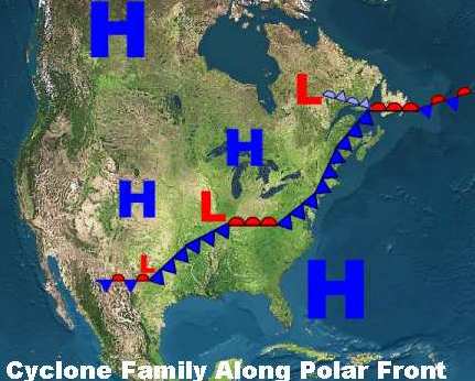
Eventually, the contrasting air masses around the low pressure cell mix well enough to weaken their contrast, thus ending a cyclone's driving force. Its storminess weakens and its pressure rises until the cyclone eventually disappears from the weather map. One cyclone's death, however, may give birth to another further downstream. As an old storm dissipates, a new cell may spin up along the western tail of the frontal zone. A chain of lows in various stages of development along the polar front is called a cyclone family. Often during the winter, a well-developed cyclone family can be seen sprawling along the polar front stretching from Newfoundland to west Texas.
Learn More From These Relevant Books Chosen by The Weather Doctor
Written by Keith C. Heidorn, PhD, THE WEATHER DOCTOR,
November 1, 2005 A version of this material was previously published by Keith Heidorn on Suite 101: Science of the Sky, 2002
For More Weather Doctor articles, go to our Site Map.
I have recently added many of my lifetime collection of photographs and art works to an on-line shop where you can purchase notecards, posters, and greeting cards, etc. of my best images.


 There are also several cyclone spawning regions around the globe. One, the Aleutian Low off Alaska, spawns the storms that worry North America's northwestern coast each winter. Its counterpart off Iceland sends storms into northern Europe. Tropical regions too have preferred locations that produce tropical storms, hurricanes and typhoons during specific periods of the year. In the Atlantic Ocean, areas west of the Azores and in the Gulf of Mexico are preferential locations for tropical storm and hurricane development from June through November.