| Home | Welcome | What's New | Site Map | Glossary | Weather Doctor Amazon Store | Book Store | Accolades | Email Us |
 | |||||||||||||||||||||||||
Weather Almanac for October 2012THE HIGHS OF HAZARDWhen we think of hazardous weather, our first thoughts are of cyclonic storms, from large blizzards through tropical storms and down to tornadoes. The anticyclone or high pressure system does not readily come to mind as a hazardous weather element. But if we look at the annual number of deaths each year in the United States due to weather conditions, those associated with anticyclones top cyclonic causes in most years. Statistics compiled by Indur M. Goklany in a report Death and Death Rates Due to Extreme Weather Events places the number of estimated US deaths for six major weather hazards over the period 1979-2002 at 30,590.
One might argue the absolute numbers — The US National Weather Service reverses heat and cold in their rankings — but the overwhelming causes are extremes of heat and cold. These are mostly attributable to cold and heat waves, which are weather phenomena associated with anticyclones. I would add to the list fatalities due to strong thunderstorms winds not associated with hurricanes and tornadoes, deaths due to poor air quality, and deaths attributable to fog-related transportation accidents. The latter two elements can be mostly attributable to anticyclones as well (though some fogs are related to frontal conditions around cyclonic waves). 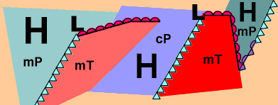 Another hazardous form of anticyclone weather not charted here, and not a likely cause of death in North America is drought. In other parts of the world, drought-related fatalities are much more evident and rank highest on the overall global list compiled by Goklany in the above study. The prime impact of drought is crop failure leading to malnutrition and starvation, particularly in the African nations. I add that anticyclones may have a further negative, though indirect, effect on other weather-caused fatalities. This is caused by the blocking action of high pressure on the movement of cyclones. The complete blocking, delaying, or re-routing of a midlatitude cyclone or tropical cyclone can cause extended periods of precipitation over a given area. In some cases, such blocking can cause extreme flooding that present a significant hazard to life. Anticyclones and Heat Waves
However, if the humidity in the air mass is high — for example, in a hot anticyclone of a maritime origin —it will reduce post-sundown surface cooling, and air temperatures may remain uncomfortably hot all night. Such hot, moist air masses are perhaps the most hazardous to human populations because the added humidity reduces the rate at which heat can be lost from the body and accelerates the likelihood of heat-related disease. For more on the impacts of heat and humidity on health, see my article Summer Discomfort — Mixing Heat and Humidity. Such high-humidity heat waves have often resulted in high death counts. Recent examples occurred during the hot summer of 2003 when an extended heat wave through Europe claimed an estimated 50,000 lives. The 1980 heat wave in the US took 1250 lives, and the heat in Chicago, Illinois during the summer heat wave of 1995 resulted in over 700 fatalities. Continental hot anticyclones form over large continental desert regions such as in North Africa and Australia or arid and semiarid regions such as found in the Central Asia steppe and the North American plains. The lack of surface moisture means more solar energy can go into surface heating, and often the daytime temperatures will exceed 100,oF (37.8oC). These dry air masses often have large diurnal temperature changes so that nights can actually be quite cool. While dry anticyclones can also be a hazard to health, fatalities due to the extreme heat are usually less than those occurring under the high heat/humidity combination. Under some circumstances, intense solar heating during the day may generate thundery weather that brings rain and wind that may be severe. Anticyclones and DroughtThe structure of a typical anticyclone is characterized by sinking air from its central core to the peripheries. Descending air is counter to the conditions necessary for cloud formation (See Making Clouds and Rain ) and thus the central core of most anticyclones is cloud-free. Only very strong convective heating can penetrate past this sinking air, and thus if clouds are present, they are often of the shallow “fair-weather” cumulus variety (cumulus humilis), which fade away in the early evening.
In North America, drought is not considered a deadly weather event for the human population, though it definitely takes a toll on plant and animal life, and may enhance wildfire conditions that threaten humans. In other areas of the world, however, the loss of agricultural production during a drought can lead to increased malnutrition and disease, and for this reason, drought is considered one of the deadliest weather situations globally. Anticyclones and Cold WavesThe opposite side of the anticyclone spectrum from the heat wave is the cold wave. Extremely cold anticyclones form over the polar regions and eventually move equatorward. Cold air temperatures further reduce moisture levels in the anticyclone and thus, the air mass loses heat through long-wave radiation to the upper atmosphere and outer space. Since extremely cold anticyclones form during the winter-sun months, they receive no or little solar energy during their formation and early life. The heat of an anticyclone continues to be lost when ice and snow cover the underlying surface. Both are very efficient at radiating their heat away and with no clouds and little moisture in the air mass, this heat is lost to the high atmosphere and space.
In the past, extreme cold waves would cause significant numbers of deaths in North America, Today, however, technology has reduced the large-scale fatality counts in any given episode through better warnings and heating technology. That said, the loss of a life here, another there, during cold weather in the United States places deaths due to extreme cold weather to the top of the Center for Disease Control’s (CDC) list for the number of weather-related deaths during the 1979-2002 period. Often, these deaths hit the silent people — the homeless, the poor and the elderly — who are caught in circumstances that prevent them from obtaining proper protection from the cold’s onslaught. Anticyclones and Air QualityOne hazard of anticyclones not included in the CDC list of deaths is the hazard of poor air quality. One likely reason for this omission is that deaths due to poor air quality are harder to identify than those due to heat or cold. In addition, we perhaps falsely believe that the days of the killer smogs such as those that hit London, England in 1952 (A subject for the December 2012 Almanac) and Donora, Pennsylvania in 1948 are relics of the past. It is perhaps true that the traditional smog episode of high sulphur dioxide and small particles of dust and soot that characterized the famed London “pea-soup” smogs of the past have been controlled in Europe and North America. However, over the last forty years or so since I began work in the field of air quality, the concept of smog shifted from the sulphur dioxide/particulate matter smogs to the other main application of the smog term, the photochemical smogs that arose first in Los Angeles, California in the post World War II years. That form of smog, characterized by high levels of surface ozone and hydrocarbon compounds, has spread across North America in the succeeding years to Denver and then most of the eastern US and Canada.
Surface layer inversions may also be accompanied by radiation fog formation, which further slows their dissipation during the daylight hours. The classic London smogs were strengthened by surface inversions that often persisted in the winter months for several days and aided by the major pollutants that enhanced the fog component of the smog. In the case of photochemical smog, the important factor is the higher temperature and sunlight that “cook” a variety of pollutants into a hazardous photochemical soup. Thus, this smog is more common in the warm weather months and can often be a partner with a heat-wave anticyclone wherein the air mass over the region is not cleansed of previous pollutants, and they accumulate over a long period. The difficulty with assessing a death toll for poor air quality anticyclones is in determining the extent that the poor air caused the death. Direct deaths usually take the already frail, elderly and extremely ill, and their deaths are attributed to other causes. Estimates of mortality related to poor air quality have been quite high and rival all weather-related causes in some estimates. According to NOAA’s brochure Air Quality as a Weather Hazard: “Poor air quality is responsible in the U.S. for an estimated 50,000 premature deaths each year; costs from air pollution-related illness are estimated at $150 billion per year.” A British Environmental Audit Committee in 2010 estimated that poor air quality was responsible for 50,000 deaths in the United Kingdom. The World Health Organization warns that 2.4 million people die each year across the globe from causes directly attributable to poor air quality. Most of these mortality estimates are based on what we can call “business as usual” levels of air quality. They do not consider the extreme deadly effect of a major incident such as befell Bophal, India in 1984 when a major release of deadly chemicals into the air killed over 25,000 outright and left many others severely injured. In such acute episodes, the impact of the deadly release may be increased by unfavorable conditions associated with a resident anticyclone. Anticyclones and FogWith clear skies and light winds under an anticyclone, radiational cooling of the surface air layer may be sufficient to bring the layer’s temperature below the condensation temperature. This cooling would result in radiation fog over a large area or in small patches. Such conditions can have deadly consequences for road transportation. The conditions may be especially dangerous when the fog suddenly forms or forms in once specific area and reduces the visibility for drivers. Reports of multi-vehicle accidents are common when radiation fogs appear, particularly during the early morning rush hours. 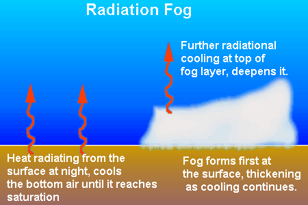 There Could Be MoreThe above conditions constitute the major hazards attributable to anticyclones. They are not all those possible, however; particularly when we look along their margins and in the transition zones between anticyclonic air masses. It is here that the clash between contrasting air masses form frontal cyclones and frontal wave systems. In the case of an extreme cold wave, the advection of the cold air on the front of the anticyclone structure (its eastern edges) is often rapid. The high winds of the cold outbreak can cause blowing and drifting snow that produce whiteout conditions, which in turn can be hazardous to transportation of any kind. In addition, when these outbreaks rush across large bodies of warmer waters, lake and sea-effect snow squalls may develop that have all the dangerous characteristics of the most severe of cyclonic blizzards. If an extremely cold arctic anticyclone moves across the warmer waters of the polar oceans, they may form an intense polar low. These storm systems are usually smaller and shorter lived than other storm systems but can generate strong winds (greater than 38 mph / 60 km/h) that produce hazardous conditions in their vicinity to polar activities such as shipping, fishing and oil/gas extraction rigs. The backside (western margin) of a warm anticyclone, particularly one of maritime origin, moves warm, moist air northward. In North America, this often pushes steamy Gulf of Mexico air northward across the center of the continent. If this air moves toward colder air moving down from polar regions, the clash often provides the ingredients for severe convective storms carrying lightning, strong winds, and possibly damaging hail and devastating tornadoes. If there is also the influence from a dry continental air mass, the famed tornado weather of Tornado Alley can erupt. Remember the Gentle
Such is the nature of an anticyclone. Learn More From These Relevant Books
|
|||||||||||||||||||||||||
 |
Now AvailableThe Field Guide to Natural Phenomena: |
Now Available! Order Today! | |
 |
 |
Now |
The BC Weather Book: |


 Most persistent summer heat waves arise when a large mass of hot air becomes entrenched over a region. Such anticyclones are typically characterized by clear or nearly skies, low wind spends, and little precipitation. The clear skies result in strong solar radiation during the summer months, which after several days dries the ground so that most of the solar energy goes into heating the soil and the surface air.
 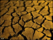 With rain-producing clouds at a premium, it is obvious that under a persistent hot anticyclone, drought conditions may prevail. The lack of rain is further enhanced by the drying of the ground surface beneath the anticyclone under the intense heat.
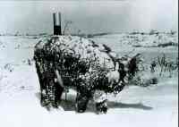 Cold air masses often follow intense winter cyclones and may have very strong winds in the transition zone behind the cyclone. Strong winds further push heat loss through windchill in exposed humans and other mammals/birds that may be detrimental to health and well-being. (See article:
  Both forms of smog occur in anticyclones because they are usually rain-free and have light winds, factors that increase the accumulation of any air contaminants and keep them there. The subsidence (sinking air) in the anticyclone core forms an elevated inversion layer (warm air above cold) that traps pollutants in a smaller volume, thus increasing their concentration. In addition, particularly in the colder months, surface inversions can form that further trap pollutants near the surface. The surface inversion forms when the radiational cooling of the surface layer forms a layer of colder air near the ground during the night. These conditions may occur at any time of the year within an anticyclone, but during the colder months, with weaker solar radiance and longer nights, these inversions are strongest and last longer into the post dawn hours.
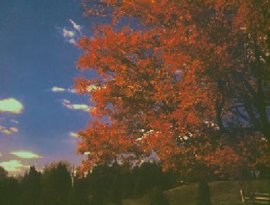 I have spent many words above to describe potential hazards associated with anticyclones. The vast majority of anticyclones, however, are gentle giants that bring us weather conditions that enhance our enjoyment and appreciation of good weather: a sunny summer day for a stroll and a picnic; a crisp autumnal Indian Summer day to enjoy the wonderful colored foliage that anticyclones produce; a welcome stretch of sun in winter; a first warm day of spring when blossoms waft fragrant aromas through the air.