When a tropical depression began to organize in the southwestern Caribbean in early September 1961, no one would have guessed that a landmark hurricane was developing. Two weeks later, as the storm known as Carla dissipated over northern Quebec, a number of milestones had been registered in American hurricane annals.
Hurricane Carla, one of two hurricanes that today would rate as a Category 5 storm during the 1961 Atlantic hurricane season (the other was Hattie), hit the Texas coast as a Category 4 storm. (Note that the Saffir-Simpson Hurricane Scale did not exist at the time.) Its winds, accompanying tornadoes, heavy rains and record storm surge unleashed destruction over a wide swath from the Texas coast to as far inland as Chicago, Illinois. Carla was, at the time, the largest hurricane to strike the US mainland and the largest on record, to date, in the Atlantic basin. It was the second most powerful to hit Texas.
As the storm raged over Texas and Louisiana, 20 known tornadoes fell from Carla’s circulation, including an F4 storm that struck downtown Galveston, Texas, killing between 6 and 12 residents. (Like the Safir-Simpson Scale, the Fujita Tornado Intensity Scale was not yet devised and has been applied in retroanalysis.)
In addition, the storm became the first major hurricane to receive intense observation by land-based radar and the new tool in the meteorologist’s toolbox, satellite imagery. The early warnings provided by these and other observations led to the largest peacetime evacuation in American history, an estimated half million residents who moved inland from the coastal zone. It also marked the beginning of live, on-the-scene television coverage, which was reported by a then unknown Texan named Dan Rather.
Radar Image of Hurricane Carla as seen by WSR-57 radar at Galveston, Texas, September 1961 Image courtesy NOAA/NWS Photo Library
The early warnings and evacuations have been credited with keeping the death toll along the Texas coast low: 31, particularly when compared to the Great Hurricane of 1900 that struck Galveston leaving 8,000-12,000 dead and the 1919 hurricane that struck Corpus Christi, Texas killing over 450. In all 43 people died in the United States from the storm’s effects. Damage estimates ranged from $300-400 million ($9-10 billion or more when adjusted to 2010 US dollars).
Storm Winds Rise
On 4 September 1961, a tropical depression developed along the Intertropical Convergence Zone in the southwestern Caribbean Sea in the early morning hours producing rain and winds rising to 32-38 mph (51-61 km/h). The hurricane center in Miami, Florida issued its first storm bulletin just before noon and later that day issued an advisory for storm intensification. Over the next several days, the depression continued with a slow by steady intensification. It reached tropical storm intensity on the morning of 5 September and named Carla, the third named storm of the 1961 Atlantic hurricane season.
Tropical Storm Carla reached hurricane force on the morning of the 6th, its central pressure now reading 984 mb at 1200 UT (6 am CST). (Central Standard Time is six hours behind Universal Time (UT), formerly known as Greenwich Mean Time (GMT or Z). To avoid confusion, the Central US time zone is used throughout, unless noted, and is not adjusted for daylight savings. ) At this time, Carla was located southeast of the northeastern tip of Mexico’s Yucatan Peninsula from where it would begin a turn to the northwest into the Gulf of Mexico headed for the western Gulf Coast. Winds had now reached 110 mph (177 km/h) and gales battered the Mexican and Cuban coasts several hundred miles from the storm center.
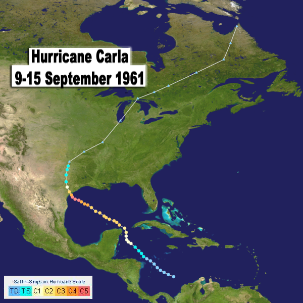
Track of Hurricane Carla, September 1961 Base image source Wikipedia with data from the US National Hurricane Center and background map from NASA.
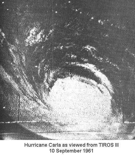
Carla continued to intensify as it moved north of Yucatan into the warm Gulf waters and headed directly for the south Texas coast. Thirty-six hours after reaching hurricane status, Carla had blossomed into a raging major hurricane (Category 3 and above) that covered the entire Gulf of Mexico. On the 9th, winds blew at 135 mph (217 km/h) and continued to rise over the next two days, peaking at 175 mph (280 km/h) during the evening on the 10th. Although the winds subsided from their peak to 165 mph (265 km/h) by midday on the 11th, the central pressure continued to fall, reaching a minimum at 931 mb at noon CST. By now, Carla had come under scrutiny of the Hurricane Hunter reconnaissance flights, and land-based radar units at Lake Charles, Louisiana and Brownsville and Galveston, Texas. As well, the newly launched (12 July) meteorological satellite TIROS III transmitted images of Carla as the storm moved over open waters.
Coastal waters began to rise three days before Carla struck the coast and continued to rise in height and fury as Carla approached at a forward speed of from 9 to 14 mph (14-22 km/h).
Carla Strikes Texas
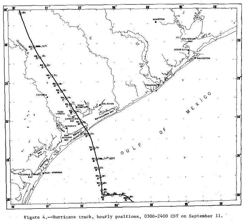
Carla’s center struck the Texas coast between Port O’Conner and Port Lavaca during the late morning of the 11th with sustained hurricane-force winds reported from Corpus Christi to Galveston. The radius of maximum winds around the central eye was 40 miles (64 km). Hurricane gusts blew along most of the Texas coast and storm winds covered most of the Gulf coast. Although Carla was now down to Category 4 level, it struck the coast with a double punch of wind and storm surge.
Track of Hurricane Carla Across the Texas Coastline, 11 September 1961 Source:NOAA Technical Report NWS 32, 1982
As the hurricane struck Port Lavaca, a peak gust of 175 mph (280 km/h) was estimated. An anemometer at the Bauer Dredging Company recorded a gust at 153 mph (246 km/h) before it was destroyed. Inland sustained winds as high as 110 mph (177 km/h) blew at Victoria, with a gust to 150 mph (240 km/h), and along the coast at the storm’s outer reaches, they reached 88 mph (141 km/h) in Galveston. Hurricane winds blew along the coast from Corpus Christi to Galveston, a separation of about 250 miles (400 km).
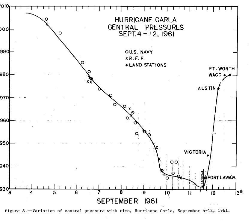
The storm’s central pressure at landfall at Port Lavaca read 935 mb at which point the instrument’s indicator went below the scale. Devoid of its energy source, Carla quickly began filling as it moved inland, and the central pressure rose rapidly over the next day, increasing by 40-45 mb in the next eight hours.
Central Pressure History of Hurricane Carla, September 1961 Source: NOAA Technical Report NWS 32, 1982
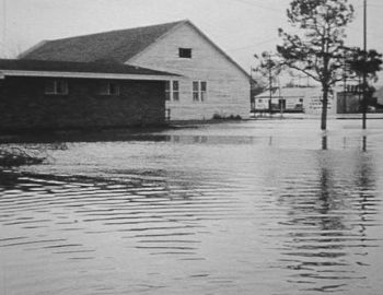
The storm surge rose from 15 to 22 ft (4.5 m) above mean sea level (MSL), the upper value estimated from debris locations near Matagorda Bay. The highest measured water level came at Port Lavaca, 16.6 ft MSL (5.06 m). Water levels of 10 ft (3.0 m) or more MSL were reported along the coast from Port Aransas to Sabine Pass. The estimated surge penetration indicated high water levels stretched 10 miles (16 km) inland and inundated 1.7 million acres with water. Carla demolished a row of dunes 98-164 ft (30-50 m) wide and cut numerous washover channels across Padre Island
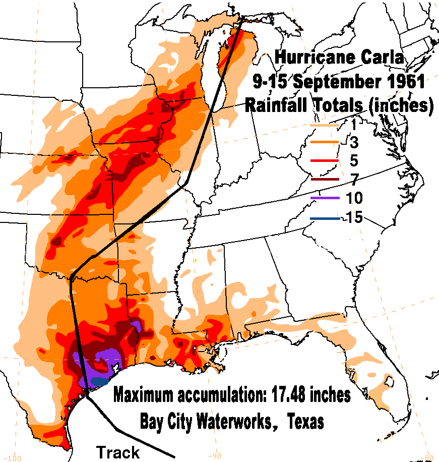
While Hurricane Carla lost much of its wind strength after making landfall, its impact had only begun in Texas. The storm barreled inland, headed directly toward Victoria and Austin. With its forward speed slowed to a pedestrian 4 mph (6 km/h) or less, rains and flooding now became the main concern with accumulations of from 10 to 16.5 inches (254-419 mm) falling as far as 50 miles (80 km) inland. The peak storm rainfall in Texas came from Bay City Waterworks at 17.48 inches (444 mm), with Galveston Airport reporting 16.49 inches (502 mm) and the Galveston City Office 14.94 inches (379 mm). Wharton, Liberty, and Dickinson each registered over a foot (30 mm) of rain.
Residents of the Galveston area likely breathed a sigh of relief that Carla did not directly hit this coastal community where memories of the great hurricane of 1900 still lingered. And while Carla did not deliver a direct hurricane punch, the storm spawned tornadoes from its mass including one of F4 ferocity that hit downtown Galveston. Eight tornadoes were associated with Carla in Texas and another ten in Louisiana (plus one each in Oklahoma and Arkansas).
The first tornadoes to strike during Carla hit St Mary, Louisiana at 10:20 pm, 10 September. The F2 twister damaged 55 homes and unroofed many others. At 1:20 pm, 11 September, Cherokee, Texas was hit by an F2 tornado that destroyed one home. A stronger tornado, rated F3, struck Harris, Texas at 5:50 pm that day, destroying 18 homes and damaging 40 others. This tornado threw cars up to 100 yards (100m). Later that night (10:20 pm), St Tammany, Louisiana suffered F2 damage.
The F4 tornado that hit Galveston on 12 September at 315 am likely began as a waterspout before coming ashore and ravaging a mile-long path through the city. It was the most destructive tornado ever to hit Galveston, and the death toll of eight (plus 55 injured) may have been higher except for the evacuation of the area due to Carla's approach. A second, rated F2, struck at 6 am on the west end of Galveston Island destroying six homes.
A tornado (F2) hit Liberty, Texas, at 6 am on the 12th. Later that day, significant tornadoes were reported at Jackson, Louisiana (F2), Union, Louisiana/Blanchard Springs, Arkansas (F2), and Red River Texas (F2).
Down, But Not Out
By 6 am CST on 12 September, Carla, was centered east of Austin, Texas, and no longer a hurricane. It would remain a tropical storm for only another 24 hours when it morphed into an extratropical storm. Storm rainfall at Victoria, Texas measured over six inches (150 mm). Around Austin, 3-5 inches fell (75-127 mm).
By the morning of the 13th, the remnants of Carla passed over Oklahoma and headed northeast toward the Great Lakes. Along the cold front associated with the Carla remnants, 4 to 8 inches (100-200 mm) of rain fell along a 70-mile (112 km) wide band from Ponca City to Fort Sill, Oklahoma. As the storm moved through Kansas, 3-8 inches (75-200 mm) of rain fell, causing severe flooding. Daisy, Arkansas accumulated 5.25 inches (133 mm) of rain. In Illinois north of the storm track, from two to six inches (50-150 mm) came down. Moline registered the greatest accumulation in Illinois with a record 6.29 inches (160 mm). The Chicago area had rainfall ranging from 2.5 to 3.5 inches (64-89 mm) that caused viaducts and basements to flood. The Chicago River rose rapidly by 5 ft (1.5 m) that required an opening of lock gates to Lake Michigan to relieve the flooding. The resulting rush of water damaged boats in Wilmette Harbor to the tune of $75,000. Across the lake in Michigan, Petosky and Traverse City totaled more than five inches (127 mm) of rain. Grand Traverse, Michigan was struck by an F2 tornado that skipped across the area, damaging farm buildings and uprooting cherry trees.
Hurricane Carla Rainfall Amounts Across Central United States Image Courtesy Hurricane Prediction Center, NOAA/NWS
By midnight on the 14th, the dying storm crossed into Canada at Sault Ste Marie. At 9 AM CST (10 AM EST), what remained of Hurricane Carla was centered over Lake Huron’s Manitoulin Island. As the storm headed for northern Quebec, the Chicago Weather Bureau Office issued the following: NO FURTHER BULLETINS WILL BE ISSUED BY THE WEATHER BUREAU ON THIS STORM. Carla was no longer a storm of concern to the American public.
The Warnings and the Tally
During the 1950s, the US Weather Bureau was slowly changing its policy toward severe storm warnings. It had long resisted the use of tornado in forecasts, feeling that a forecast of tornado potential or occurrence would lead to widespread panic, which would have more injurious consequences than the storms. But with better science and observation tools that could narrow the affected forecast area, that reluctance was fading.
As early as 4 pm CST on 7 September, the New Orleans Weather Bureau office (WBO), now in charge of storm forecasting, issued a hurricane watch for the coast from Apalachicola, Florida to Morgan City, Louisiana. It indicated that hurricane warnings would likely be issued in the near future. With the approach of the large and powerful Carla, the decision was made to emphasis the evacuation of the low-lying areas. New Orleans WBO advised that residents of islands and low-lying coastal areas consider evacuation before escape routes were cut off. As Carla grew and took a turn to the west, the watch area extended then shifted westward.
By 10 am CST on the 8th, the watch area was in effect for the whole Texas coast and the WBO advised movement away from islands and low areas of coast there. Two hours later, the watch became focused on the Gulf Coast west of the Mississippi. Twenty-four hours later, the watch became a warning, calling “HURRICANE CARLA LARGE AND DANGEROUS”…”ALL …SHOULD EVACUATE ALL ISLANDS AND LOW COASTAL AREAS…IMMEDIATELY.”
Further warnings issued before the storm hit the Texas coast continued to emphasis these words: “Large and dangerous” and “should evacuate.” At 8 pm on the 9th, the hurricane advisory bulletin stated: “IF EVACUATION OF ALL ISLANDS AND LOW COASTAL AREAS ALONG THE LOUISIANA THE UPPER AND CENTRAL TEXAS COAST HAS NOT BEEN COMPLETED EVACUATION SHOULD BE HASTENED BEFORE IT IS TOO LATE.”
Satellite Image of Hurricane Carla, 10 September 1961 Photo Source:NOAA Technical Report NWS 32, 1982
By 8 am on the 10th, the latest bulletin message added that “REPORTS INDICATE THAT MOST OF THE AREA HAS BEEN EVACUATED.”
At 11 am, 11 September, the US Weather Bureau issued a Tornado Forecast for an area 50 miles (80 km) either side of a line from Baton Rouge, Louisiana to Lufkin, Texas from 2 to 8 pm CST. Then, at 10 am on 12 September, all hurricane warning were dropped, but small craft warnings continued on the Gulf waters, and flood warning were issued where needed. A few hours later, the authority on this storm passed from the New Orleans WBO to the Kansas City, Missouri office as the remnants of Carla moved northward. Two bulletins were issued for heavy rains and flooding before authority passed to the Chicago WBO where the final bulletins were issued on Carla.
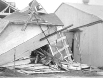
The initial damage estimate in Texas totaled $300 million, two-thirds to property and a third to crop losses there. In Texas, 1914 homes, 568 farm buildings and 415 other buildings were destroyed, minor to major damage affected at least 51,000 homes, 5500 farm buildings and 2000 other buildings. Louisiana damage estimates totaled $25 million, $6 million to agricultural losses and $5 million each to both building and oil rig losses. Total damage in the remainder of the US was pegged at around $500,000. In current (2010) dollars the estimated cost of Hurricane Carla to the nation was in the order of $9-10 billion. (Note that there are several ways to determine the equivalent cost in current times and that other estimates may differ. An analysis by Pielke et al sets the cost as high as $13-14 billion.)
Damage along Texas Coast following Hurricane Carla Photo Source:, Texas Archive of the Moving Image
Forty-six deaths were blamed on Carla, thirty-four in Texas — including eight in the Galveston tornado — six died in Louisiana, five in Kansas and one in Missouri. The low death toll, in stark contrast to the 8000 or more who died in 1900 in Galveston, was attributed to the evacuation of from 250,000 to 500,000 from affected areas, the largest evacuation in US history until that preceding Hurricane Rita in 2005.
Using the Hurricane Severity Index — developed by Chris Hebert and Bob Weinzapfel of ImpactWeather — which accounts for storm size and intensity, Carla rates Number 1. Based on the storm’s intensity and amount of destruction, the name Carla was retired from the Atlantic hurricane name list.
Rather Be First
Okay, it’s a bad pun. But, former CBS Evening News Anchor Dan Rather shared a historic moment with Hurricane Carla, and it became a stepping stone for him to a distinguished career in broadcast journalism.
In 1961, Rather was working as the news director for Houston television station, KHOU. "Hurricane Carla was so huge and potentially so destructive that pretty quickly it became clear to the weather bureau that what they needed to do is convince people they needed to evacuate," says Rather. Rather understood that Carla was a large and dangerous storm, and he began the coverage with images from the Houston area Weather Bureau office. He became the first to show a live radar shot of the hurricane on television as it marched toward the coast. "Our graphics were a little unpolished, but that day we did something that had never been done before: put a live radar image of a hurricane on television," Rather remembers. "People could see in the living rooms how huge the hurricane was."
"It's hard to imagine today, as we routinely air not only radar but satellite images," Rather mused in a 2005 interview. "But that day we agonized over whether showing our viewers what was going on would cause mass panic. … Ultimately, up to a half a million people evacuated the coast and the storm's relatively low death toll, 46, confirmed that we'd made the right call. …While the death toll was reasonably small, the reason it was low is because people listened and got out."
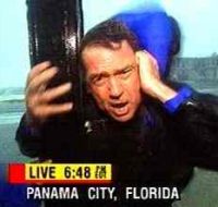
As Carla began raging along the Texas coast, Rather took a news crew out to the Galveston Island to report live on the storm, and they eventually became stranded there. In one memorable moment, he delivered the report by hanging onto a palm tree.
Feeding live reports over the Houston station as the outer bands of Carla battered the Galveston area, Rather showed the fury of the storm. KHOU was a CBS-affiliate and the immensity of the hurricane drew the attention of the parent station. They began monitoring the local situation for the national audience using Rather’s feed. It was to be the first live national broadcast of conditions in a hurricane.
The broadcast drew the attention of the brass of CBS News to Rather. Soon after, he began his long association with the network that ultimately led to the anchor desk of the Evening News. Rather would cover many hurricanes live during his career, but Carla was the first, his and the nation’s.


 Okay, it’s a bad pun. But, former CBS Evening News Anchor Dan Rather shared a historic moment with Hurricane Carla, and it became a stepping stone for him to a distinguished career in broadcast journalism.