| Home | Welcome | What's New | Site Map | Glossary | Weather Doctor Amazon Store | Book Store | Accolades | Email Us |
 | ||||||||||||||||||||||||||||||||||||||||||
The 1900 Galveston HurricaneOn September 8, 1900, a killer hurricane struck the Texas coastal city of Galveston. This hurricane would become the greatest natural disaster, by number of deaths, in United States history: 8,000 by accepted figures, perhaps as many as 12,000. Of that total, 6,000 perished in Galveston alone. The tragedy killed more Americans than any other natural disaster, indeed, more than the legendary Johnstown Flood, the San Francisco Earthquake, the 1938 New England Hurricane and the Great Chicago Fire combined. The storm first became organized in the warm equatorial mid-Atlantic Ocean west of the Cape Verde Islands about August 27, 1900. A ship encountered the tropical depression on the 28th, noting in its log book: winds from the south southwest at Beaufort force 6, about 40-50 km/h (25-31 mph). As the system intensified, it moved due westward toward the Leeward Islands of the Lesser Antilles. (The accompanying storm track map shows the storm's apparent position at 12-hour intervals beginning at midnight (UTC) on the 27th.) By the morning of August 31, its position was about 360 km (200 miles) southeast of Puerto Rico and headed for Hispaniola. 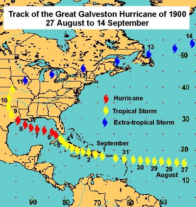 As September began, the storm center was located in the Caribbean Sea about 360 km (200 miles) south of Santo Domingo City, Hispaniola. While its winds were still gathering strength, the storm's rains deluged the islands of the Greater Antilles. In Jamaica, for example, kilometres of railway roadbed were washed out. Then the rains began in Cuba. The director of the Belen Observatory in Havana, Father Gangoite, saw the approach of the storm. At this time, the centre of the storm was believed to be about 280 km (175 miles) south of mid-island Cuba. He wrote: "This kind of storm sometimes produces heavy rain over this island, and acquires greater strength as it moves out over the Atlantic." On Monday, September 3rd, Santiago, Cuba was inundated by 254 mm (10 inches) of rain in just eight hours, 320 mm (12.58 inches) in 24 hours and, before it finally stopped raining, 618 mm (24.35 inches) over two days. The storm crossed Cuba on the 4th and then left the northern island early on the 5th. Father Gangoite's words had been correct about the rain, and now he was correct about the increase in strength. The storm, which would soon become known as the Great Galveston Hurricane, intensified to hurricane force as it approached the Florida Keys. But Gangoite was wrong about its track. The hurricane continued northwestward reaching a point midway between Havana and Key West, Florida by the morning of the 5th. The hurricane continued to move northwestward passing the Florida Keys and bringing high winds to southern Florida. Observations from Jupiter, Florida at the southeast tip of the state reported NE winds at 48 mph (77 km/h). Forecasters at the US Weather Bureau office in Washington DC examined the maps and, using their knowledge of past hurricane behavior, expected the storm would curve along a northeasterly track across Florida and then northward along the US east coast. The office telegraphed a forecast to New Orleans at midday on September 5 stating the storm "probably will be felt as far north as Norfolk [Virginia] by Thursday night [September 6] and is likely to extend over the middle Atlantic and South New England states by Friday." The Galveston Hurricane, however, had other ideas. Rather than follow the more likely path which would recurve back toward the Atlantic, it continued on its west-northwest course. As it moved into the Gulf of Mexico, it gave gale force winds to Tampa on Florida's west coast, Key West, and Jupiter on Florida's east coast, assuring weather forecasters in Washington that it was moving over the state. But a region of high pressure located to the east blocked this path, and the storm turned into the Gulf and toward Galveston.
Although storm warning signals were posted along Louisiana and north Texas coast from the 4th to the 6th, no one in the Weather Bureau office associated these conditions to the approach of the storm which had raked the Florida Keys. It appears this belief may have been furthered by an incorrect report from Havana that placed the storm 240 km (150 miles) northeast of Key West. Off the Louisiana coast, the steamship Louisiana encountered high winds and seas on the morning of the 6th. The ship's barometer dropped from 29.60 inches to 29.25 inches in just four hours, and it was still headed down. At 1 pm, the glass read 28.75 inches. Captain Halsey had never seen such a low reading. He wrote in his log: "...I think the wind was blowing at the rate of more than 100 miles per hour [160 km/h]." At the peak of the storm, Halsey estimated the winds at 150 mph (240 km/h). If true, the hurricane had reached an intensity that would be classified as a Category 4 Hurricane on the Saffir-Simpson Scale.
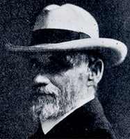
Ignoring any potential danger from the storm winds, Captain J.W. Simmons of the Pensacola set sail into the Gulf the morning of the 7th. At noon, Simmons checked his barometer. It read 29.90 inches of mercury. Two hours later the mercury had fallen an inch, and the winds had risen to gale force and beyond. The glass fell to 28.55 inches, and as he fought to save his ship, Simmons estimated the winds at 100 mph. In Galveston, Isaac Cline and the other Weather Office meteorologists John D. Blagden and Joseph Cline (Isaac's brother) watched the barometer fall and the seas rise. In his Special Report on The Galveston Hurricane of September 8, 1900, Cline observed: "The barometer commenced falling on the afternoon of the 6th and continued falling steadily but slowly up to noon of the 8th, when it read 29.42 inches. The barometer fell rapidly from noon until 8:30 p.m. of the 8th, when it registered 28.48 inches, a fall of pressure of about one inch in eight and one-half hours." As to the seas:
What Cline was seeing was the beginning of the storm surge being pushed ahead of the hurricane as it moved towards the Texas coast. As dawn broke on Saturday morning, Galveston residents looked across the Gulf waters in amazement. Cline observed in a telegram addressed to the Bureau Central Office in Washington: "Unusually heavy swells from the southeast, intervals of one to five minutes, overflowing low places south portion of city three to four blocks from beach. Such high water with opposing winds never observed previously."
Elsewhere that morning, Dr Samuel O. Young, Secretary of the Cotton Exchange and Board of Trade, also stood watching the Gulf. He would later write: "Saturday morning, about six a.m., I went on the beach. I saw that the tide was high, but that it had fallen again and was then at a stand. While I was out there the tide began to rise again, and soon washed up to and over the street railway track. I was certain then that we were going to have a cyclone...By twelve o'clock the wind had increased in violence to between forty and fifty miles an hour, blowing from the north, and the water, both in the bay and Gulf, was very high and still rising. At one o'clock I visited the wharf front. The wind had shifted to a point or two east of north, and was over fifty miles an hour. The bay water was over the wharves and was slowly encroaching on the Strand. All low places were completely inundated. From the bay I went to the Gulf side, and found the tide very high and the water very rough." That Saturday afternoon September 8, 1900, hell was unleashed against the City of Galveston. The winds reached storm force about 1 pm after which the wind increased steadily and reached hurricane velocity about 5 pm. As the hurricane rolled in on this island city, it pushed Gulf waters high over the shore.
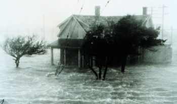
Young now watched the spectacle from his home: Between five and six o'clock the wind became almost due east and increased in violence. The debris fairly flew past, so rapid had the tide become. At twenty minutes to six o'clock...there was a marked increase in the violence of the wind. I went to a west window to watch a fence I had been using as a marker on the tide. While I was looking, I saw the tide rise fully four feet in one bound. In a few minutes several houses...went to pieces and floated away, and the debris from a number of large buildings began to float by from the east." Many now tried in vain to seek better shelter. But the waters rose to chest-deep and higher, reaching the upper floors of buildings before tearing the buildings from their foundation and sending them crashing inland. Leaving a building meant death by drowning, to stay courted death in its wreckage. Cline too watched the tide rise from his home: "The water rose at a steady rate from 3 p.m. until about 7:30 p.m., when there was a sudden rise of about four feet in as many seconds. I was standing at my front door, which was partly open, watching the water, which was flowing with great rapidity from east to west. The water at this time was about eight inches deep in my residence, and the sudden rise of 4 feet brought it above my waist before I could change my position. The water had now reached a stage 10 feet above the ground at Rosenberg Avenue (Twenty-fifth street) and Q street, where my residence stood. The ground was 5.2 feet elevation, which made the tide 15.2 feet. The tide rose the next hour, between 7:30 and 8:30 p.m., nearly five feet additional, making a total tide in that locality of about twenty feet. These observations were carefully taken and represent to within a few tenths of a foot the true conditions." The storm's greatest measured wind velocity, averaged for five minutes, was 84 miles per hour at 6:15 p.m, with a two-minute average at 100 miles per hour, Cline would report. But this was the last official wind measurement in Galveston, for the anemometer blew away at this time. Duty observer John D. Blagden estimated that prior to 8 p.m. the wind attained a velocity of at least 120 miles per hour. At 8:30 pm he recorded the barometer's lowest reading at the Weather Office: 28.48 inches. But lower pressure were observed elsewhere. The first mate of the English steamer Comino, moored at Pier 14, logged a pressure of 28.30 inches. But Galveston was not in the eye of the storm, which passed to the southwest of the city. Meteorologists would later assign the minimum central storm pressure at 27.49 inches (931 mb).
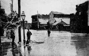
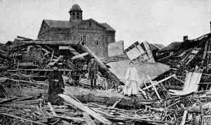
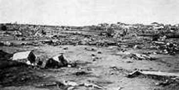
The utter destruction of Galveston and surrounding areas had begun. Through the night buildings were dashed by waves and torn by winds; debris swirled in a mad dervish, crashing through windows and walls and killing animals and people all across the city. Nearly every Galvestonian feared for their lives and for at about 20 percent of the population those fears were realized. Overnight, the wind steadily diminished in velocity from their evening hurricane force, and at 8 am the morning of the 9th, they blew from the south at a relatively gentle 32 km/h (20 mph). With the dawn, the survivors looked out on "one of the most horrible sights that ever a civilized people looked upon. About three thousand homes, nearly half the residence portion of Galveston, had been completely swept out of existence, and probably more than six thousand persons had passed from life to death during that dreadful night" in Cline's words.
[More on the stories of the horror experienced by the people of Galveston can be found in my September 2000 Weather Almanac and on many of the other sites whose links are given below.] Most accounts of the Galveston Hurricane of 1900 stop here and focus on the human tragedy that hung over the devastated city. Although the storm winds likely dropped below hurricane force shortly after the storm moved inland, the storm continued its destructive path into Texas, before crossing the southern Plains states and finally recurving to the northeast to pass across the lower Great Lakes. It eventually reached the Atlantic Ocean after crossing over the Canadian Maritime Provinces and Newfoundland on September 12-13. Along the Texas coast and just inland, the towns of Texas City, Dickinson, Lamarque, Hitchcock, Arcadia, Alvin, Manvel, Brazoria, Columbia and Wharton suffered great damage and loss of life and property. Over half of the buildings in Houston were damaged. Along a path two hundred miles wide, wind and rain blasted inland Texas from the Gulf to the Red River Valley. The inland towns of Hempstead, Chapel Hill, Brenham and Temple were ravaged. Leaving Texas, the storm moved northward across Oklahoma, Kansas and Iowa where it became an extratropical, but no less deadly, storm. Copious rain fell in Minnesota, as much as 127 mm (5 inches) being measured. Six logger were killed on the Eau Claire River in Wisconsin. Winds in Chicago were reported at 128 km/h (80 mph) on the 11th. Telegraph lines were downed, cutting communications across the Midwest. The storm next moved across Michigan toward southern Lake Huron and the Canadian Province of Ontario. Toronto experienced winds of 80 km/h (50 mph) on the evening of the 11th. Windows were broken across the city. To the south, orchard owners in the Niagara Peninsula and along the Lake Erie shore saw apples, pears and peaches ripped from their trees. About half of the crop, which was ready for harvest, was destroyed -- a loss estimated at $1,000,000 at the time. On Lake Erie off the Ohio shore, the storm took thirteen lives on the waters when two ships were lost: the steamer John B. Lyon and the schooner Dundee. Although winds had diminished as the storm crossed Ontario, they still made travel on the waters unsafe. On the Ottawa River, yachts at Britannia and Aylmer, Ontario were grounded or dragged away from their anchorage. The steam tug Albert, caught in the gusty winds, released the 14,000 logs it was towing, and the winds scattered them along the shore. As the storm system approached the Canadian Maritime Provinces on the 12th, it gained strength and again became a killer. Before it moved out into the Atlantic, over 80 Canadians would be dead, possibly 100 or more. Deaths would also be attributed to the storm in Newfoundland (not yet a part of the Canadian Confederation) and the nearby French islands of St. Pierre et Miquelon. In Prince Edward Island waters, eight small fishing schooners of the Gloucester County, New Brunswick fleet, the Anglesea, Emma, Fly, Frances, Garfield, Hibernia, Nellie and Penguin were lost with 38 reported drowned. In addition, the 35 ton Reality with a crew of four, sunk in Cascumpec Bay at Alberton, Prince Edward Island. Two other fishing vessels the Japan and Midnight were believed to have also foundered in the stormy waters. On land, extensive damage was also reported. The Halifax Morning Chronicle described it as the worst Nova Scotia storm since 1873, but reported only minor damage within Halifax. On Prince Edward Island, a lobster factory at Seacow Head was totally demolished; a large barn and windmill were blown down at Wilmot; and most orchards had fruit torn from the trees. In New Brunswick, the storm surge and wind-driven waters, coupled with a favourable alignment of the earth, sun and moon, drove an exceptionally high tide up the Bay of Fundy and the Petticodiac River. With its last slap at North America, the storm crossed Newfoundland from Corner Brook to Gander on the 12th. In its wake, 82 schooners had been driven ashore or sunk and another 100 seriously damaged. At least 50 lives were lost and another 25 missing and presumed dead. South of Newfoundland, the fishing fleet of St. Pierre et Miquelon lost nine schooners and 120 men, leaving 50 children fatherless. On September 13, the last remnants of the storm raced northeastward across the North Atlantic Ocean curving toward Scandinavia, and finally dying, according to Erik Larson's book Isaac's Storm, somewhere over Siberia. Nearly a century later, folk singer/songwriter Eric von Schmidt would describe the storm in a song titled Wasn't That a Mighty Storm? By all accounts it was that and more. The Cold Facts of the Great Galveston Hurricane
For Further InformationFor more information on the 1900 Galveston Hurricane, see these articles:
The full text of Isaac Cline's storm report appeared in Monthly Weather Review (September 1900): Special Report on The Galveston Hurricane of September 8, 1900. Information on the storm after it left Galveston can be found in John D. Reid's account: The Great 1900 Galveston Hurricane in Canada Finally, The Weather Notebook has devoted three programs to the event: The Great Galveston Hurricane of 1900 has also been documented in several books over the past few years. Two are reviewed in the Reviews section of The Weather Doctor. Isaac Cline's 1945 book Storms, Floods and Sunshine: An Autobiography recounts his life story including memories of the storm that took his wife, destroyed his home and nearly killed Isaac, his daughters and his brother Joseph. Isaac's Storm is a recent historical account of the devastation, much of it centered around Dr Isaac M. Cline, the Director of the Galveston Weather Office at the time of the tragedy. (The book relates the story every bit as gripping as The Perfect Storm.) Learn More From These Relevant Books
|
||||||||||||||||||||||||||||||||||||||||||
 |
To Purchase Notecard, |
Now Available! Order Today! | |
 |
 |
NEW! Now Available in the US! |
The BC Weather Book: |


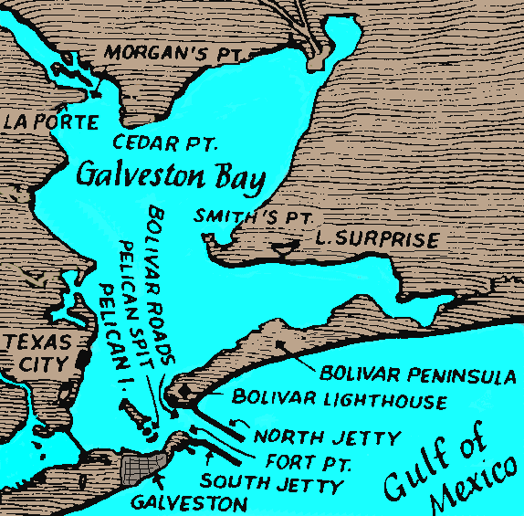 In 1900 Galveston was one of the most important cotton markets in America. The population of the city was just around 35,000. Galveston is an island city located on the eastern end of Galveston Island, a sand barrier island about 30 miles long and from 1.5 to 3 miles in width between Galveston Bay and the Gulf of Mexico. Its peak elevation is about 8.7 feet above sea level.