| Home | Welcome | What's New | Site Map | Glossary | Weather Doctor Amazon Store | Book Store | Accolades | Email Us |
 | |||||||||||||||||
Weather Almanac for September 2004STORM SURGEWhen we think of hurricanes and similar tropical storms, howling winds and incessant rains form the first impression. But historically, and for many areas still today, the storm surge accompanying these storms has been the greatest killer. (Because of advances in forecasting and storm emergency responses, surge deaths in the US have declined, and flooding taken the mantle of deadliest component.) Many thousands of the victims of the Great Galveston Hurricane of 1900 died as the result of storm surge, and surge and subsequent flooding in Bangladesh has been responsible for hundreds of thousands of death in the past.  3 meter (16 ft) of storm surge strikes the Florida Panhandle during Hurricane Eloise, 1975 |
|||||||||||||||||
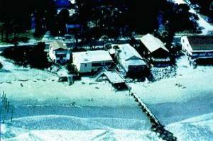 | 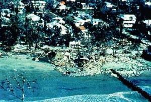 |
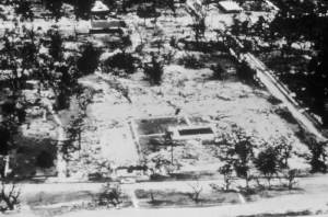
A section of shoreline before and after storm surge at Folly Beach, SC. (Photo Courtesy of NOAA/US Dept of Commerce) | |
Even when the surge front does not destroy, the wall of water produces flash flooding that can cut off escape routes, rush into underground structures such as basements and subways, and flood subterranean utilities. And more often than not, the surge waters flood inland areas for days after the storm has passed. In a low-lying areas like in coastal Bangladesh, surge flood waters added onto storm rainfall can be particularly devastating, and is often the factor responsible for the high death toll in many Bangladesh storms.
In many storms, the damage done by storm surge along the coastline can rival or exceed that caused by wind or rain. Costs can only rise as people seek to colonize shoreline areas for their homes, businesses, and recreation. In many coastal areas of the American Gulf and East Coast, knowledge of potential storm surge damage is now being used to plan and zone coastal habitation. Planners and emergency response programs are aided in determining the potential damage from storm surge by mathematical models such as SLOSH which look at the effects of ocean waters pushed by severe storms.
Prior to the advent of our current intensive storm and sea warning programs, many people died when storm surge struck ahead of landing storms. Estimates of the deaths attributed to the surge from the 1900 Galveston Hurricane reached around 6000, and in Bangladesh the numbers reach into the hundreds of thousands. Surge continues to take many lives in areas where evacuation plans and adequate storm shelters are not available. In the United States and Canada, the number of surge-related deaths has reduced drastically in the past decades, in part due to sophisticated forecasting tools and focused education programs aimed at those living and working along the shorelines. Most surge deaths in these countries are now mostly the reckless who tempt fate by moving into danger and the foolish who do not heed evacuation edicts.
In the United States in the last century, eight hurricanes that made landfall on the American coast are of particular note due to their surge impacts:
Hurricane Opal caused extensive storm surge damage in Florida from Pensacola Beach to Mexico Beach with a maximum storm tide of 7.3 m (24 ft) recorded near Fort Walton Beach. Total damage estimates reached billions of dollars. Hurricane Hugo pushed a storm surge estimated at 6 m (19.8 ft) at Romain Retreat, South Carolina. Storm surge in excess of 3.7 m (12 ft) from Hurricane Audrey resulted in an estimated 390 deaths over the flat coast of southwestern Louisiana, pushing water as far inland as 40 km (25 miles).
The Galveston Hurricane, as mentioned, inundated the city and smashed thousands of wooden buildings with a 4.8 m (15.7 ft) wall of water. Many who died had rushed to the sea wall to witness the storm. The Okeechobee Hurricane made landfall near Palm Beach and when the center passed near Lake Okeechobee, a lake surge caused the lake to overflow its banks and inundate the surrounding area to a depth of 2-3 m (6 to 9 ft). Over 1,800 people died in Florida, most from the surge.
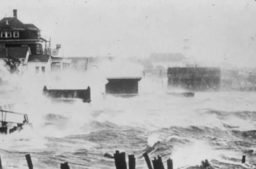
The Labour Day Hurricane brought a surge estimated as high as 6 m (20 ft) across the Florida Keys sweeping hundreds to their deaths (the official toll was 423). Many of the dead were World War I veterans in Civilian Conservation Corps camps sent to work on the Overseas Highway being built to connect the Florida Keys with the mainland. The Great New England Hurricane surprised residents of New England with strong winds and a storm surge of 4.3-7.0 m (14-23 ft) that inundated the coasts of Long Island, New York, Rhode Island, Connecticut, and southeastern Massachusetts and destroyed coastal homes, marinas and yacht clubs.
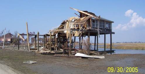
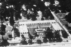 |  |
The Richelieu Apartments before and after Hurricane Camille. (Photo Courtesy of NOAA/US Dept of Commerce) | |
Hurricane Camille deserves more space than I can give it here, because this storm was significant in many ways. Of the above-mentioned storms, it is the latest with significant fatalities due to storm surge and perhaps did more to make Americans aware of the dangers of wind and surge at the shore. One of only four Category 5 hurricanes to hit the continental United States, Camille generated the greatest storm surge ever recorded in the US, a 7.3 m (24-ft) high dome of water that pushed into Pass Christian, Mississippi on Aug. 17, 1969. The best estimates say that Camille killed 172 people on the Gulf Coast, with surge accounting for most of these deaths.
Where I and others feel Camille taught a great, though tragic, lesson, was the underestimation by many of the surge impacts. Many Mississippi coastal residents believed their buildings were immune to the strength of the hurricane winds, but did not reckon on the power of the surge. Although damage across southern Mississippi was staggering, most structures within about 800 m (1/2 mile) from the ocean just vanished with only footings and slabs remaining to indicate their former presence.
Of the many stories of Camille, none is as tragic as that of the 24 people who remained in the Richelieu Apartments in Pass Christian. Rather than evacuate, the story goes, they held a "hurricane party" to ride out the storm in what they believed was a soundly built apartment complex able to withstand the winds. The story of a hurricane party is, in fact, untrue, a long-standing tale; however, the building was considered safe for refuge. When the surge hit the building, it inundated the first and second floors and swept the structure from its foundation. Only one seeking shelter there survived, a woman swept more than 19 km (12 miles) inland. Today, their tragic ending is often told to remind those of the dangers of fooling with Mother Nature where storm meets shore.
One of the strongest storms to impact the coast of the United States during the last 100 years, Hurricane Katrina blew with sustained landfall windsat 140 mph (225 km/h) — a strong Category 4 hurricane — and minimum central pressure the third lowest on record at landfall (920 mb). Katrina produced widespread devastation along the central Gulf Coast states of the US. Cities such as New Orleans, Mobile, and Gulfport bore the brunt of Katrina's fury. Storm surge off Mobile Bay inundated Mobile, Alabama. A 20 to 30+ foot (6.1 to 9.1 + m) storm surge flooded large portions of Biloxi and Gulfport, Mississippi as Gulf of Mexico floodwaters spread several miles (kilometres) inland.
 |
To Purchase Notecard, |
Now Available! Order Today! | |
 |
 |
NEW! Now |
The BC Weather Book: |