 |
 |
| Home | Welcome | What's New | Site Map | Glossary | Weather Doctor Amazon Store | Book Store | Accolades | Email Us |
 | |||||||||||||
A Study in Opposites: ThundersnowAs a wet snow falls, I watch the flakes shifting down from a deep-grey sky. Then, to my left, a throaty rumble following a muted flash catches my attention. Lightning and thunder? During the winter season? For most of us, thunder and snow in the same sentence, let alone the same word thundersnow, seems a contradiction, the symbols of summer and winter weather coexisting.
The central American states, mostly those west of the Mississippi River (Missouri, Kansas, Nebraska, Iowa, Colorado, Minnesota, Oklahoma and into northern Texas), define a loose arc in which thundersnows occur a few times each winter. For residents around the Great Lakes, the Great Salt Lake, or in the continent's mountainous terrain, however, thundersnows can be more common, though often many are unreported. Thundersnows have also been reported around the Sea of Japan and the North Sea. Mountaineers scaling Mount Everest, and other high peaks, have reported thundersnows during their ascents as some of their scariest moments. Observations of thunder/lightning with snowstorms have been found in records and commentaries since the 19th century in the Western world and in China for nearly a millennium. However, only in the past decade have meteorologists delved into the phenomenon of thundersnow, likely due to the uncommonness of the events. In the United States, only 1.3% of cool-season (October-May) thunderstorms reported coincide with snowfall, and only 0.07% of snowstorms have associated thunder. (A five-year study of thundersnows in the central US by University of Missouri meteorologist, Patrick Market, began in 2003.) Reports of thunder/lightning with snow are also hindered by several factors. Thunderstorms dropping snow to the surface generally produce fewer lightning strokes than rain-dropping thunderstorms. The snowflakes absorb and diffuse the light of lightning and sound of thunder more readily than does falling raindrops. (While thunder during rain is generally heard 6.5-8 km (4-5 miles) away, the range for snow-related thunder is no more than 1.6 km (1 mile). The colder weather in which thundersnow occur may also contribute to the relative rarity of the event as fewer observers are out of doors.
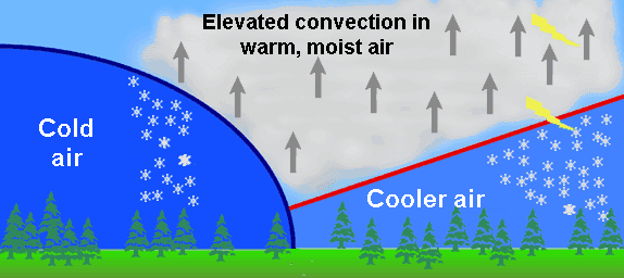
Causes of ThundersnowWhat causes thunder and lightning during some snowstorms? Those who study the formation and life cycle of thunderstorms forming during the warm season understand that a strong, warm and moist updraft is a necessary condition. In the warm season, these updrafts generally arise from the surface, but they need not. It appears that only those thundersnows developing over bodies of warm water arise from warm surface air. Most others, particularly those observed in the US central states, develop when the necessary convective process starts at higher altitudes than the surface air layer. The two most important mechanisms for producing most thunderstorms are layers of instability — a region of the atmosphere with a tendency to promote upward air motions — and strong dynamic lifting — factors other than buoyancy that move air upward. Working in tandem, these two mechanisms provide that lift necessary to turn a precipitating cumulus cloud into a towering, lightning-producing cumulonimbus. In a warm-season, airmass thunderstorm, the atmospheric instability needed to start the process begins at the sun-heated ground. The moist air warmed at the surface becomes less dense (more buoyant) and begins to rise high into the sky, a process known as surface convection. The less dense the air is relative to the surrounding air, the higher and faster it will rise; in such cases we have a deep layer of surface instability. But in the cold season, and particularly in air conducive to snowfall, the lower troposphere is dry and cold which makes it relatively stable and inhibits parcels of surface air from rising. However, the troposphere can have many layers of distinct airs with differing vertical thermal gradients (called lapse rates), and when a layer of warmer, moist air wedges its way between a surface cold layer and colder air above, a region of elevated instability forms that may give rise to elevated convection, the convective rise of air beginning at an altitude above the surface. The effect is enhanced when there is cooling in the middle troposphere layers above the warm air wedge to enhance the convection potential.  An example of elevated convection at an occluded front resulting in thundersnow.There are several mechanisms that can cause strong dynamic lifting of air (which I look at in more detail in What Goes Up: Introduction to Updrafts ). When one of these occurs in an atmosphere that has layers of instability, it becomes a trigger for air to begin rising and continue to do so. In this manner, strong updrafts are formed. The lifting can work on elevated layers as well as surface layers and thus produce elevated convection. In the most intense cases of dynamic lifting, such as air forced over a mountain range, the resulting cumulus clouds have all the characteristics of purely convection cloud formation. In late fall and winter, when cold air moves across the relatively warm waters of the Great Lakes and other large water bodies, intense convective storms often develop that drop snow upon reaching the downwind shores (see Lake-Effect Snowfall on this site). When the waters are significantly warmer than the air, they act similar to the solar-heated ground in the summer and form surface convection. Under these conditions, intense cumulonimbus cloud development may arise that induces lightning flashes. When these snow squalls strike with heavy snows and gusty winds, they are punctuated with flashing lightning and booming thunder, i.e., thundersnow. Thundersnows are also found in mountainous regions where the forced upslope flow (strong dynamic lifting) of moist air produces thunderstorms at higher elevations. In many thunderstorms, precipitation begins as snow at high altitudes but melts in warmer air below. However, in the mountains the snow does not melt before reaching the mountain surface. At such elevations, the air temperature may be near or below freezing. One of the most significant thundersnow events struck Buffalo, New York in late November 2000. The lake-effect storm dropped 78.7 cm (31 inches) of snow over the region in three days. Reports cited "frequent lightning" flashing during the early storm. A thundersnow storm in Louisville, Kentucky on 17 January 1994, dropped about 60 cm (2 ft) of snow. Learn More From These Relevant Books
|
|||||||||||||
 |
To Purchase Notecard, |
Now Available! Order Today! | |
 |
 |
NEW! Now Available in the US! |
The BC Weather Book: |


