The great tropical storms roaming the world's oceans and seas have earned the right for individual names:
Andrew and Katrina, Keli and Jelawat. Extratropical cyclonic storms, those forming from the clash of polar
and tropical air masses, have not yet been honoured with individual names. However, some extratropical
storms take on such unique characteristics that they are often recognized with a unique name for the genre.
The Gulf of Alaska storms fit within this category as do the Colorado Lows.
But for two North American groups of cyclonic entities, their names are more descriptive: the Nor'easter
along the Atlantic coast, the Alberta Clipper that races across the continent our of the Alberta plains.
The Nor'easter
In a cyclonic flow pattern, winds spiral around the low pressure centre in a push-and-pull struggle between
pressure gradient, Coriolis and frictional forces. In a well-developed cyclonic storm with a proper placement
of surrounding high pressure cells, this flow regime develops sectors with strong northeasterly, southwesterly
and northwesterly winds. Therefore, any strong cyclonic storm has the potential to be called a southwester, a
northwester, or a northeaster.
However, only along the North American Atlantic coast, from Cape Hatteras northward to the Canadian
Maritimes, can a storm truly be called a Nor'easter. By accepted definition, a Nor'easter should have gale
force or stronger winds initially blowing from the northeast. These storms often bring heavy precipitation,
falling as rain, snow, or at times, freezing rain. Along the coastline, heavy surf generated by offshore storm
winds may cause extensive damage to the shoreline. Nor'easters are the most common, widespread severe
weather events to worry New Englanders and Maritimers.
The term Nor'easter arose in the colonial days before the concept of wind circulation around a low pressure
center was established. Storms were then considered to travel from the direction of the wind. If a storm came
with southwesterly winds, it originated from the southwest. A Nor'easter, therefore, originated, and arrived,
from the northeast of those feeling its fury. Those beliefs began to change in the mid-eighteenth century, in
part through the insights of Benjamin Franklin.
Franklin had looked forward to viewing a lunar eclipse but had been denied the visage by clouds associated
with a storm that rolled into Philadelphia that evening. Later, he was surprised to hear that his brother living
in Boston had seen it. Franklin had expected the obscuring clouds had moved over Philadelphia from the
northeast, around Boston, but Franklin's brother wrote the eclipse occurred before the clouds rolled in. From
this and other correspondence, Franklin began to suspect that, contrary to then-current beliefs, large storms
moved quite differently than indicated by their main wind direction. He reasoned that his "eclipse storm" had
come from the south or southwest rather than the northeast. While Franklin never fully grasped the cyclonic
flow pattern, he did realize that storms often moved in directions other than that of their winds.
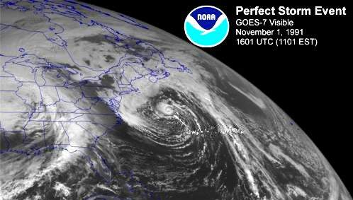
Satellite view of a Nor'easter aka "The Perfect Storm" Courtesy NOAA
Nor'easters have become legendary along the Atlantic Coast for their fury and impacts. The Blizzard of
'[18]88 and The Perfect Storm are two prime examples. Most nor'easters arise from cold-season storm
systems that first move through the Ohio Valley or Gulf States to a position off the Atlantic Coast. There,
many receive a regeneration of intensity when they encounter the warmer ocean waters, particularly if the
Gulf Stream waters are involved. When conditions are ideal, the storms become bomb cyclones, a term
relating to a sudden and dramatic deepening of the central pressure, at a rate equal to or exceeding 1 millibar
per hour over a 24-hour period. The suddenness of a bomb cyclone's fury is matched only by the resulting
winds and precipitation.
Nor'easters generally hug the coast as they move north. Their northeast storm winds rush off the ocean with
unbridled fury. The wind flow pattern also permits the storm to pick up relatively warm and very moist air
from the ocean which it drops when meeting colder air on the western side of the system. If the air is cold
enough, the precipitation falls as snow, at times measured in feet rather than inches — merging blizzard
with nor'easter.
The Alberta Clipper
While Nor'easters are creatures of the East Coast, many are born in the lee of the Rocky Mountains. There
are two prime mid-continent spawning grounds for storm systems. One is around the State of Colorado; the
other the Province of Alberta. Those systems born around Colorado are simply called Colorado Lows.
Storms born in Alberta (perhaps reborn is a better concept as many arise from the remnants of Gulf of Alaska
lows weakened in crossing the Rockies) possess unique characteristics that have led to the handle Alberta
Clippers as they move swiftly out of the Canadian Prairies, like the Clipper sailing ships of old, bringing
frigid weather to the east.
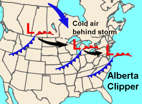
Alberta Clippers form on Alberta's high plains east of the Canadian Rockies. Once organized, they "sail"
southeastward under the push of a northwesterly jet stream into Montana and the Dakotas, then turn across
the Great Lakes basin headed toward the Atlantic Coast. This track, however, leaves them far from the
moisture sources of the Pacific, Atlantic and Gulf of Mexico. As a result of their high forward speed and
dryness, the average Clipper rarely deposits huge snowfalls, dropping instead only a few centimetres (inches)
of light, powdery snow in its passing.
At full maturity a Clipper's cold winds may reach 65 km/h (40 mph) with gusts to 100 km/h (62 mph).
Although the amount of snowfall may be small, these strong, frigid winds produce severe blowing and
drifting of any snow on the ground, thus causing true blizzard conditions along the storm's track.
When an Alberta Clipper passes, it often ushers in bitter outbreaks of polar air, which continue the storm's
wrath for days after the low itself has moved off. Combine strong northerly winds and bitterly cold
temperatures in the storm's wake, and you get severe ground blizzards, days of white-outs (severe blowing
and drifting snow that reduce near-surface visibility to zero), and dangerous windchill factors.
When Alberta Clippers moving across the Great Lakes bringing frigid, gusty northwest winds in their wake,
major lake-effect snowfalls strike the lee shores, often bringing heavy snow to the region. Occasionally, an
Alberta Clipper crosses the Appalachians heading southward and becomes re-energized by warm Atlantic
coastal waters to be reborn a Nor'easter.
Learn More From These Relevant Books Chosen by The Weather Doctor
Williams, Jack: The Weather Book, 1997, Vintage Books, ISBN 0-679-77665-6.
For More Weather Doctor articles, go to our Site Map.
I have recently added many of my lifetime collection of photographs and art works to an on-line shop where you can purchase notecards, posters, and greeting cards, etc. of my best images.