High above the Earth's surface, rivers of air rush their way around the globe in a high speed current that often spawns side eddies that we on the ground call cyclones. Knowledge of the position of these streams, known as the jet stream because of their speed, is vital to accurate general weather forecasts and severe storm predictions. Knowledge of the location of the jet stream is also important to airlines and other long-distant air transportation.
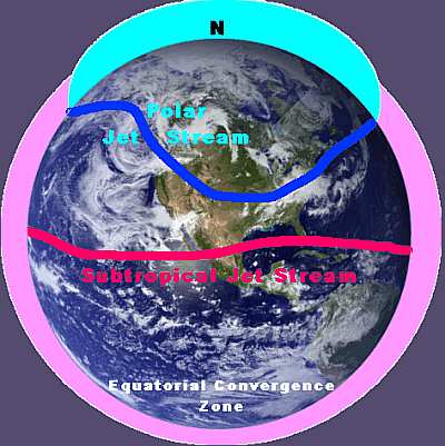
In North America, the jet stream is a common topic for discussion on various weather media reports, but they often give us the impression there is just one such stream. In fact, both hemispheres have two major jet streams (which may sometimes branch): the polar jet stream and the subtropical jet stream. On occasion, a fast-moving current in the lower atmosphere may also, and this is known as a low-level jet.
Northern Hemisphere's two major jet streams: the polar jet stream and the subtropical jet stream.
The jet stream is generally defined to be a current of fast-flowing air at high altitudes, somewhere between 8-15 km (25,000 to 48,000 ft or about the 40-20 hPa/400-200 mb pressure level) above the Earth's surface. Jet stream wind speeds blow, by definition, in excess of 94 km/h (57 mph) and can reach nearly 500 km/h (300 mph). The jets are quite variable in their properties but a typical jet stream is hundreds to thousands of kilometres (miles) in length, about 160 to 500 km (100-300 miles) wide and about a kilometre deep (5/8 mile). (Though the polar jet streams form along the polar front in the Prevailing Westerlies belt that circles the planet, they do not always circumnavigate the globe as a continual stream.) The jet winds usually have a west to east direction, though they may loop with large north-south deflections.
I will only touch briefly on the subtropical jet stream here and focus more on its more influential (to residents of most of the US and Canada) sibling, the polar jet stream. The subtropical jet stream tends to form during the hemisphere's cold season. It is initiated by warm air flowing away from the tropical regions. This poleward air flow, however, is steered off its north-south course by the Coriolis effect until it takes a mostly easterly path at around 30 degrees latitude at an altitude of about 15 km (48,000 ft). The subtropical jet stream may aid in the development and steering of tropical storms and disturbances.
The Polar Jet Stream
The northern polar jet stream (also called the polar jet, or the mid-latitude jet stream, but generally just the jet stream) is the one having the most influence on weather across much of the United States and Canada, and thus it gets the most attention on local and national weathercasts. The polar jet stream can usually be found somewhere in the latitude belt from 40-60 degrees at an altitude from 7600 metres to 10,600 m (25,000-35,000 ft).
The highest wind velocity is found in the jet stream core where speeds can be as high as 460 km/h (290 mph) in the winter. The jet stream core region averages 160 km/h (100 mph) in winter and 80 km/h (50 mph) in summer. Those segments within the jet stream where winds attain their highest speeds are commonly known as jet streaks.
The polar jet stream position marks the location of the strongest temperature contrasts between polar and subtropical latitudes on the Earth surface. Therefore, the strongest polar jet stream velocities usually occur during the winter months. During the summer months, when the equator-pole surface temperature differences are less dramatic, the jet winds blow slower and are usually found at higher latitudes.
Jet Stream Formation
The polar jet stream is formed in the region of greatest contrast between polar and subtropical air known as the polar front where the cold, dry polar air meets the warm, moist air from the subtropical regions. From a climatological viewpoint, the position of the polar front forms a more or less even band around the globe, slipping north and south with the seasonal changes.
In the vicinity of the polar front, the air pressure drops more rapidly with increasing altitude in the denser cold air than in the less dense warm air. This temperature effect on air density results in air pressure at any given altitude being higher on the warm (equatorward) side of the polar front than on the cold (poleward) side. When cold air and warm air masses sit side by side, the higher the altitude, the greater the pressure difference between the cold and warm air. Thus, across the polar front, the horizontal pressure differential (or gradient) causes air to flow from the warm side of the front towards the cold side.
Once the air begins to flow, it is deflected by the Earth's rotation (called the Coriolis effect) and prevented from flowing directly from high to low pressure. Air flowing from higher pressure towards lower pressure is deflected to the right in the Northern Hemisphere (or to the left in the Southern Hemisphere). The resulting flow produces a westerly wind current generally flowing towards the east, parallel to and above the polar front. Very strong temperature and pressure gradients in the polar frontal zone can intensify these wind speeds to over 94 km/h, thus forming a jet stream.
Polar Jet Stream separates cold polar air from warm tropical air.
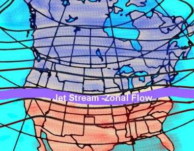
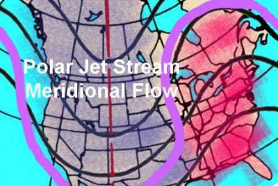
Unlike the climatological position of the polar front, its day-to-day position and shape can vary in latitude and develop north-south loops in the frontal boundary The streambed of the jet stream can vary widely with these frontal position changes and kinks much like a riverbed develops serpentine bends and meanders. When the flow is mostly west to east, the jet stream is said to be in zonal flow. But the jet can take wild north-south swings as it flows, a condition termed meridional flow.
Meandering polar jet stream often takes wild north-south swings.
The position and meanders of the polar front and jet stream are of major importance in defining the weather patterns and conditions over the globe. In the next part, we will look at how the jet stream/polar front affects the weather in North America.
Learn More From These Relevant Books Chosen by The Weather Doctor
Williams, Jack: The Weather Book, 1997, Vintage Books, ISBN 0-679-77665-6.
Written by Keith C. Heidorn, PhD, THE WEATHER DOCTOR,
November 1, 2005 A version of this material was previously published by Keith Heidorn on Suite 101: Science of the Sky, 2002
For More Weather Doctor articles, go to our Site Map.
I have recently added many of my lifetime collection of photographs and art works to an on-line shop where you can purchase notecards, posters, and greeting cards, etc. of my best images.