The polar front and its associated jet stream have a major influence on the weather conditions surrounding it. Many storms form along the polar front in the vicinity of the jet stream's maximum winds. Because of the association of the jet stream with the polar front, media weather maps often include the jet stream's position as a rough indicator of continental divisions between warm and cold air masses. Here is why.
From a climatological viewpoint, the position of the polar front forms a more-or-less even band around the globe at mid-latitudes in both hemispheres. The average polar-front position slips north and south with the seasons in response to the annual hemispheric heating cycle. Like my waistline's annual cycle, the polar frontal belt shrinks poleward in the summer months and then expands toward the subtropics during the winter.
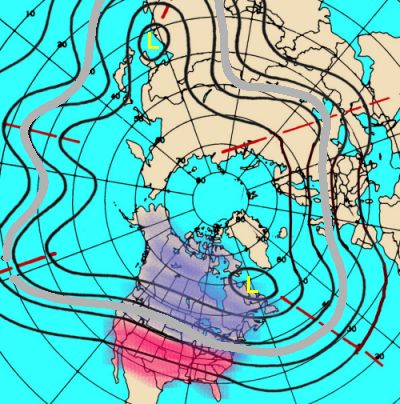
Global Pattern of Long (Rossby) Waves Wave troughs are indicated by red lines, polar front by grey line.
From a meteorological viewpoint, however, the polar front is not an evenly encircling latitude belt but an undulating zone around the globe that is ever-changing as masses of warm and cold air push away from their regions of origin. Of particular interest to meteorologists and weather forecasters is the ever-changing pattern of long-waves that form around the polar front. These long-waves, very visible on polar projection maps, undulate around the hemisphere with three to six wave cycles. (Long waves are also known as Rossby waves in honour of Swedish meteorologist C.G. Rossby who gave us many early insights into the impacts of upper atmosphere features on weather.)
At times, that global belt fits tight, having three or four, small-amplitude undulations (little north-south latitude variation) around the hemisphere. At other times, it has as many as six large-amplitude loops (great north-south variation). How those wave loops sit over the hemisphere, or portion thereof, determines what temperature regimes are experienced on the surface below.
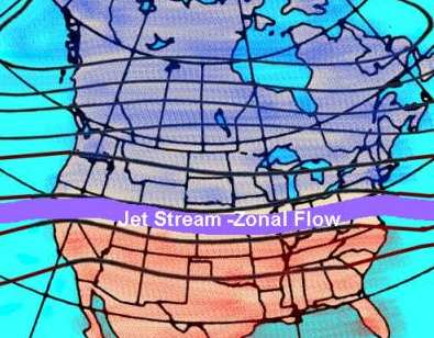
When a long section of the polar front, as seen on continental weather maps, is smooth like the surface of a calm sea, the upper-level winds, including associated jet streams, run generally parallel to the latitude lines, a condition called zonal flow. Under zonal-flow, north-south undulations of the frontal boundary are small, and the surface temperatures across the continent, as seen in the isotherm (lines of equal temperature) pattern on the weather map, layer in zonal (east-west) bands with warm air to the south and cold air to the north.
But like occupants of a small boat riding that calm surface, we may be lulled during persistent zonal flow by a stretch of nearly indistinguishable day-to-day temperature changes, often remaining near the climatological mean for that time of year. Despite the unfounded desires of those living in the mid-latitudes to believe there is a truly "normal" state of weather from which departures are abnormal, such stable zonal patterns are but a temporary state. We live not in a meteorological Camelot, where it never rains til after sundown — or the Tropics where it always rains in late afternoon — but in a region subject to very changeable-weather regimes.
Dominant Zonal Flow Pattern over North America
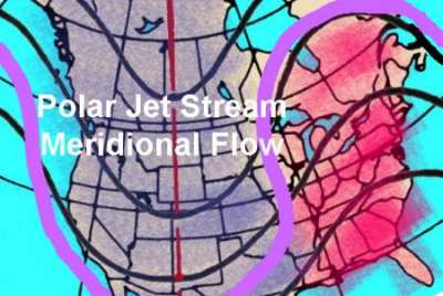
Dominant Meridional Flow Pattern over North America
Thus, when a zonal flow pattern cuts off the exchange of heat between the polar region and the tropics, great thermal contrasts develop across the polar front. And this becomes the zonal pattern's downfall. Eventually, some chink, some small perturbation, develops in the zonal pattern, and a short wave, with initially small north-south extent, arises upon the polar front. If the short wave amplifies (grows in size), it can distort the flow into a new pattern that crosses the latitude lines, a pattern termed meridional. In meridional flow, cold air rushes southward while warm air streams northward.
As the polar-front meridional pattern rises into Rossby waves of deep north-south extent, it severely rocks our "temperature boat." When the wave, and associated jet stream, plunges southward, we find ourselves in a deep upper-level trough with temperatures quite cold below it. When we rise high on the upper-level ridge, or crest of the passing Rossby wave, the surface experiences warm, even hot, temperatures.
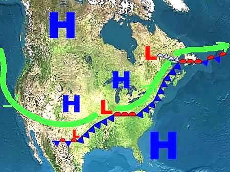
Often, the intense temperature changes brought by the meridional flow are expressed by frontal patterns associated with a surface low-pressure system: warm air moving northward behind the warm front; cold air descending southward behind the cold front. Not only are cyclonic storms spawned in the vicinity of the peak jet stream winds (called jet streaks), but they are often pushed rapidly eastward by the jet stream above.
Jet Stream (green line) associated with Polar Front and Cyclone Family
So when you look at a weather map with the polar jet stream position drawn on it, you can generally tell what type of weather you will be having. If north of the jet, it should be relatively cold, if south, warmer conditions should prevail. And, if the jet stream is flowing overhead, look for stormy weather to dominate.
Learn More From These Relevant Books Chosen by The Weather Doctor
Williams, Jack: The Weather Book, 1997, Vintage Books, ISBN 0-679-77665-6.
Written by Keith C. Heidorn, PhD, THE WEATHER DOCTOR,
November 1, 2005 A version of this material was previously published by Keith Heidorn on Suite 101: Science of the Sky, 2002
For More Weather Doctor articles, go to our Site Map.
I have recently added many of my lifetime collection of photographs and art works to an on-line shop where you can purchase notecards, posters, and greeting cards, etc. of my best images.