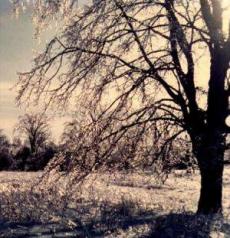
Last night, a thin wedge of a major winter storm crawled across the county. For ten hours the rains fell, but these were not ordinary rains, for when they struck, the water began to freeze. By morning, the freezing rain had deposited several centimetres of clear ice on all exposed surfaces. The in its aftermath, the skies. When dawn broke, the first rays of the sun struck the tops of the leaf-less maples along the ridge to the west, shining back in a dazzling light. As the sun rose further, its brilliance reflected and refracted off ever more of the crystal garden which covered the countryside. Barbed wire fences sparkled like diamond necklaces. Weeds rising from the snow resembled the stems of crystal goblets. Rough wood shone while gentle breezes played branches like wind chimes; stronger gusts breaking long ice chains, sending them tinkling and crashing as they hit the ground.
Periods of freezing rain like this one may fall in any winter storm crossing eastern North America. When the fall of freezing rain persists and ice accumulates, meteorologists classify the storm as an ice storm. Ice storms transform roads into huge skating rinks and leave downed power lines and broken trees in their wake. However, like a heavy snow storm, the damage and inconvenience are often tempered by dazzling beauty.
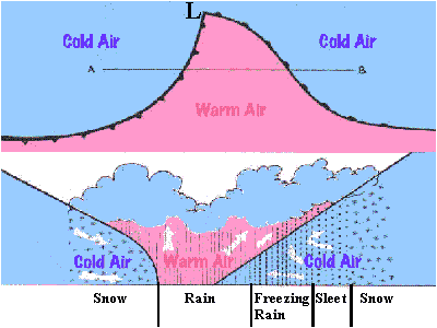
Residents of the eastern United States and Canada may experience freezing rain any time between late October and early May. Storm systems that produce freezing rain generally move across eastern North America from the southwest bringing warm, moist air from the Gulf of Mexico into collision with the very cold Arctic air of a high-pressure ridge to the north.
(For details on the Great Ice Storm of 1998 in the southeastern Canada and northeastern US, see The Great Ice Storm of 1998)
Ice storms most commonly develop along a line stretching from northern Texas to Newfoundland in slow-moving low-pressure systems where there is a large temperature difference between the warm Gulf air and cold Arctic air. Local accumulations of ice may be heavy if the storm stalls over a region for an extended period. Ice storms lasting 12 hours or more generally produce ice accumulations several centimetres thick and affect an area that may range from a few square kilometres to areas covering several states/provinces. The typical ice storm swath is 50 km (30 mi) wide and 500 km (300 mi) long. Ice storms generally warrant major headlines only one year in three.
Ice storms may be comprised of either glaze ice or rime ice. Meteorologists classify transparent and homogeneous ice forming on vertical and horizontal surfaces as glaze. Glaze ice resembles ice-cube ice in apperance. Its amorphous, dense structure helps it cling tenaciously to any surface on which it forms. In contrast, if the ice is milky and crystalline, like sugar, it is termed rime. Rime ice is less dense than glaze ice and clings less tenaciously, therefore damage due to rime is generally minor compared to glaze ice.
Ice storms typically begin with snow and strong easterly winds conditions well ahead of an approaching warm front. The snow, however, changes briefly to sleet and then to rain that freezes on impact, coating all exposed surfaces with a growing layer of ice.
(Often, freezing rain is mistakenly called sleet. Technically, however, sleet is composed of already frozen droplets — ice pellets — whereas freezing rain is still liquid until it hits a surface, freezing after impact. Freezing rain may often be mixed with sleet.)
Freezing Rain Formation
In advance of the warm front of an ice storm, warm, moist air moving in from the warm sector overruns the surface cold air ahead to produce the characteristic vertical temperature layering (a low-level temperature inversion of warm air above and cold below) of the pre-warm front atmosphere. As this air rises in altitude over the cold air, it cools and its vapour begins to condense. By the time it reaches the upper levels of the clouds, its temperature has dropped below freezing, and much of its condensing vapour forms into ice crystals.
In this very moist environment, the ice crystals quickly grow into snowflakes. Now too heavy to remain suspended in the air, they begin to fall into the air below. If the temperature of this air is below freezing (0oC = 32oF), the flakes remain frozen and fall to the ground as snow. However, if the air layer is sufficiently warm and deep, the snowflakes melt and continue their descent as raindrops. To reach the ground as
freezing rain, however, the raindrops must be supercooled as they fall through a cold air layer near the ground before striking any surface.
[Supercooling of the water drops means that the temperature of the water in the raindrops must fall below 0oC (32oF) without freezing. Although we commonly speak of 0oC as water's freezing point, water, especially in the droplet form, rarely freezes at this temperature. Pure ice, on the other hand, melts at 0oC, thus, this temperature should be more correctly called the melting point of ice.) The temperature of freezing will vary with the size of the water droplet and the concentration of any impurities in it. Very small droplets of pure water may not freeze spontaneously until the temperature has fallen to around -40oC (-40oF).]
Whether freezing rain forms from the cold rain or not depends critically on the characteristics of the surface cold air layer. If the layer is too thick or too cold, it will refreeze the rain into ice pellets (sleet). If the cold layer is too warm or too shallow, the rain will continue to the ground as normal rain and will not freeze unless the temperature of the ground or some other surface it contacts is well below freezing. Often small temporal or spatial differences in air temperature and in droplet size result in freezing rain mixed with sleet, snow or non-freezing rain.
The sensitivity of freezing rain formation to the temperature of this lower air layer makes precise forecasting of formation, amount and ice accumulation rate difficult, particularly since sites measuring the vertical temperature distribution are few and widely spread across the affected region.
In most cases of glaze formation, the temperatures of the air, the rain water, and the surface are at or slightly below 0oC, especially in those events where icing is extensive. Glaze ice usually forms when the air temperature near the surface is in the narrow range of -4oC to 0oC (25oF to 32oF).
Once the water droplet strikes a surface, the violent impact triggers a rapid
transformation of the supercooled liquid water to ice.
For heavy glaze ice formation, the rain should fall rapidly as large, slightly supercooled drops, and the rate of freezing on the surface must be slower than the rainfall rate. With small drops and rapid freezing, the resulting ice is rime ice having a more crystalline, sugar-like texture and lacking the transparency of glaze.
Freezing Rain Impacts
When transportation depended on foot power and beasts of burden,moving along dirt or gravel roads, glaze storms were generally considered more inconvenience than hazardous, except perhaps for those who travelled through wooded areas where falling branches and trees were a danger. Pavement and the automobile brought new travel hazards to both drivers and pedestrians. On relatively, smooth horizontal surfaces such as road pavement and sidewalks, glaze ice forms rather uniform, smooth slippery sheets which do not break when weight is applied to the ice. For drivers, the consequences of icing can be serious, for stopping distances on glaze ice are ten times greater than on dry pavement, and double that on packed snow.
Power and communication systems using overhead lines are perhaps hardest hit by ice storms, as the great ice storm of 1998 in New England and Quebec attests. Hanging wire cables collect ice until the cable breaks or the rain stops. Diameters of these ice-coated cylindrical cables may reach five centimetres, adding a weight of 15 to 30 kilograms per metre (10-20 pounds per foot) to the wire. Lines not broken directly under the ice's weight may succumb to the combined forces of ice and wind, or by trees and branches falling across them. Even days after the storm has abated, lines may break when they react to the sudden change in their load as the ice falls from them. Vibrations, often violent, may also occur as the ice falls, snapping weak points in the line under the added strain.
Freezing rain, however, affects more than just human technology. Animals and plants -- both wild and domestic -- may be killed or injured by ice accumulation. Ice damage to trees rivals disease and insects as destructive agents. Like power cables, tree branches and trunks collect ice in vast quantities. Conifers are the most resistant trees owing to their great flexibility, tapered shape, and lack of trunk branching — evolutionary adaptations which permit them to survive winters in heavy snow regions. A 15-m (50-foot)conifer can accumulate as much as 45,000 kg (99,000 lb) of ice during a severe storm.
Deciduous trees exhibit a wide range of vulnerability to ice. Elms and fruit trees are among the most vulnerable while oak and beech are among the most tolerant of ice loading. In general, younger deciduous trees are better able to survive than older ones due to their more supple nature and limited branching. Multiple large branches in a tree generally leads to more breakage; heavy ice accumulation on a multi-branched trunk may even cause a tree to split in two.
Icing damages plants by sealing leaves, stems and buds from the air, thereby suffocating these parts. Similarly, ice sheets formed over snow surfaces, should they persist, may suffocate or poison overwintering species such as winter wheat.
Animals active in the winter must also cope with the effects of an ice storm. Many animals starve when they are unable to reach seeds, buds, or other food locked in the ice. Deer, for example, find it difficult to browse when young shoots become encased in ice. Birds unable to find a sheltered perch during the storm may have their feet frozen to a branch or their wings covered in ice making them unable to fly. Grouse buried in snow drifts are often encased by the ice layer and suffocate.
While a walk through a forest after an ice storm may give the impression of large-scale destruction amid crystalline beauty, an ice storm also provides several vital functions. The same mechanical action that downs branches also releases seeds, promotes regeneration, prunes dead or dying branches, and indirectly provides nesting and sleeping cavities for birds and other animals.
Although ice storms are generally disliked by most of the population, they provide weather watchers with hours of entertainment as each additional look reveals new beauty. One of the most awesome sights I have ever witnessed was the ice-encrusted, mixed deciduous woods atop the Niagara Escarpment near Milton, Ontario back-lit by the setting sun. As the sun's rays emerged from below the cloud base, the surrounding ebony cloud deck provided the perfect backdrop for the dazzling crystal ice clinging to the trees.
Learn More From These Relevant Books Chosen by The Weather Doctor
For More Weather Doctor articles, go to our Site Map.
I have recently added many of my lifetime collection of photographs and art works to an on-line shop where you can purchase notecards, posters, and greeting cards, etc. of my best images.


 Last night, a thin wedge of a major winter storm crawled across the county. For ten hours the rains fell, but these were not ordinary rains, for when they struck, the water began to freeze. By morning, the freezing rain had deposited several centimetres of clear ice on all exposed surfaces. The in its aftermath, the skies. When dawn broke, the first rays of the sun struck the tops of the leaf-less maples along the ridge to the west, shining back in a dazzling light. As the sun rose further, its brilliance reflected and refracted off ever more of the crystal garden which covered the countryside. Barbed wire fences sparkled like diamond necklaces. Weeds rising from the snow resembled the stems of crystal goblets. Rough wood shone while gentle breezes played branches like wind chimes; stronger gusts breaking long ice chains, sending them tinkling and crashing as they hit the ground.
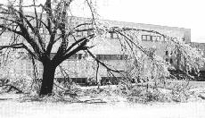 Periods of freezing rain like this one may fall in any winter storm crossing eastern North America. When the fall of freezing rain persists and ice accumulates, meteorologists classify the storm as an ice storm. Ice storms transform roads into huge skating rinks and leave downed power lines and broken trees in their wake. However, like a heavy snow storm, the damage and inconvenience are often tempered by dazzling beauty.
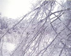 Ice storms most commonly develop along a line stretching from northern Texas to Newfoundland in slow-moving low-pressure systems where there is a large temperature difference between the warm Gulf air and cold Arctic air. Local accumulations of ice may be heavy if the storm stalls over a region for an extended period. Ice storms lasting 12 hours or more generally produce ice accumulations several centimetres thick and affect an area that may range from a few square kilometres to areas covering several states/provinces. The typical ice storm swath is 50 km (30 mi) wide and 500 km (300 mi) long. Ice storms generally warrant major headlines only one year in three.
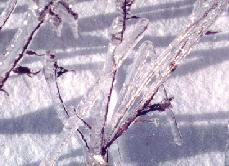 Ice storms may be comprised of either glaze ice or rime ice. Meteorologists classify transparent and homogeneous ice forming on vertical and horizontal surfaces as glaze. Glaze ice resembles ice-cube ice in apperance. Its amorphous, dense structure helps it cling tenaciously to any surface on which it forms. In contrast, if the ice is milky and crystalline, like sugar, it is termed rime. Rime ice is less dense than glaze ice and clings less tenaciously, therefore damage due to rime is generally minor compared to glaze ice.
 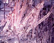 Ice storms typically begin with snow and strong easterly winds conditions well ahead of an approaching warm front. The snow, however, changes briefly to sleet and then to rain that freezes on impact, coating all exposed surfaces with a growing layer of ice.
 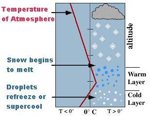 Whether freezing rain forms from the cold rain or not depends critically on the characteristics of the surface cold air layer. If the layer is too thick or too cold, it will refreeze the rain into ice pellets (sleet). If the cold layer is too warm or too shallow, the rain will continue to the ground as normal rain and will not freeze unless the temperature of the ground or some other surface it contacts is well below freezing. Often small temporal or spatial differences in air temperature and in droplet size result in freezing rain mixed with sleet, snow or non-freezing rain.
 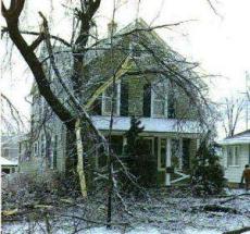 When transportation depended on foot power and beasts of burden,moving along dirt or gravel roads, glaze storms were generally considered more inconvenience than hazardous, except perhaps for those who travelled through wooded areas where falling branches and trees were a danger. Pavement and the automobile brought new travel hazards to both drivers and pedestrians. On relatively, smooth horizontal surfaces such as road pavement and sidewalks, glaze ice forms rather uniform, smooth slippery sheets which do not break when weight is applied to the ice. For drivers, the consequences of icing can be serious, for stopping distances on glaze ice are ten times greater than on dry pavement, and double that on packed snow.
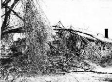 Power and communication systems using overhead lines are perhaps hardest hit by ice storms, as the great ice storm of 1998 in New England and Quebec attests. Hanging wire cables collect ice until the cable breaks or the rain stops. Diameters of these ice-coated cylindrical cables may reach five centimetres, adding a weight of 15 to 30 kilograms per metre (10-20 pounds per foot) to the wire. Lines not broken directly under the ice's weight may succumb to the combined forces of ice and wind, or by trees and branches falling across them. Even days after the storm has abated, lines may break when they react to the sudden change in their load as the ice falls from them. Vibrations, often violent, may also occur as the ice falls, snapping weak points in the line under the added strain.
 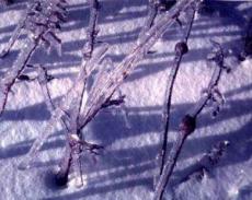 Freezing rain, however, affects more than just human technology. Animals and plants -- both wild and domestic -- may be killed or injured by ice accumulation. Ice damage to trees rivals disease and insects as destructive agents. Like power cables, tree branches and trunks collect ice in vast quantities. Conifers are the most resistant trees owing to their great flexibility, tapered shape, and lack of trunk branching — evolutionary adaptations which permit them to survive winters in heavy snow regions. A 15-m (50-foot)conifer can accumulate as much as 45,000 kg (99,000 lb) of ice during a severe storm.
 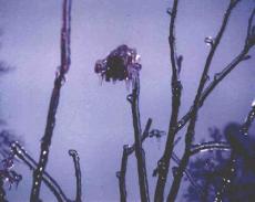 Animals active in the winter must also cope with the effects of an ice storm. Many animals starve when they are unable to reach seeds, buds, or other food locked in the ice. Deer, for example, find it difficult to browse when young shoots become encased in ice. Birds unable to find a sheltered perch during the storm may have their feet frozen to a branch or their wings covered in ice making them unable to fly. Grouse buried in snow drifts are often encased by the ice layer and suffocate.