Break Out: Arctic Outflow Winds on the Pacific Coast
Winters along the northern Pacific coast of North America -- particularly British Columbia and the Alaskan Panhandle -- are much milder than its latitude (49-62 deg N) would indicate. The prime factor for the moderate temperatures is the influence of Pacific Ocean waters. The thermal inertia -- the slow response of the great water volumes to solar and atmospheric heating -- of the Northern Pacific waters results in a moderating influence on air temperatures that produces a small annual temperature range (and with seasonal extremes coming later than at interior sites). As a result, winter temperatures at sea-level stations on the mainland shoreline and many offshore islands average only a few degrees off the freezing mark.
But a few times each winter, frigid arctic air bursts out from the interior mainland, spilling out through the mountain gaps and rushing through fjords, to chill coastal areas with bitter gale-force winds. These outbursts are called arctic outbreaks or arctic outflows.
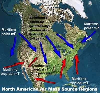
Each winter, the region of interior Alaska, the Yukon Territory and portions of northern British Columbia and Alberta become spawning grounds for frigid, arctic continental air masses: cold, dry and dense. Under nearly sunless skies for much of the winter, the spawning ground receives little heat input at the surface. The surface, however, radiates its heat away very effectively -- ice and snow are excellent heat radiators despite their cold temperature -- and thus its temperature falls, then falls some more as the days pass, chilling the air in contact with it to bitter temperatures often less than minus 40 oC/F.
Arctic air masses are very dry as well as cold, having few clouds and an extremely low water vapour content (absolute humidity). The low water vapour content further permits the loss of heat from the surface and the air above because water in vapour form is a very effective greenhouse gas (the liquid water that forms cloud droplets behaves similarly in retarding radiative heat loss). The lower the water content, the more radiative heat is lost directly to space.
Eventually, these arctic air masses become large enough in size to vacate their spawning ground and push southward, carrying their "cold" toward the equator. Because of their great cold, these air masses are very dense and thus push surface pressures to high values (generally 103.0 kPa and higher).
In the eastern portions of the source region, arctic outbreaks slide across the Prairie Provinces heading toward collisions with warm, moist air travelling north from the Gulf of Mexico over eastern North America, from the western foothills of the Rockies to the Great Lakes, New England and southern US states. But these are not the arctic outbreaks of interest to those living on the Pacific Coast, for they are effectively blocked by the western mountain ranges and are further impeded from moving coastward by the push of the upper atmosphere's prevailing westerly wind belt.
By similar mechanisms, arctic cold air masses also build within the inter-mountain valleys of the ranges from the Rocky Mountains to the Coastal Range. These cold masses may have formed there or may have slipped in when "young" from northern arctic regions. Settling into British Columbia's interior valleys, the air is trapped between the mountains, and many continue to grow colder. Eventually, most of these air masses mix with mild, moist Pacific air flowing in from the coast and dissipate. A few, however, become so large and heavy that they overcome the elevations of the coastal mountains and cascade like a broad waterfall across the coast, flooding over ocean waters.
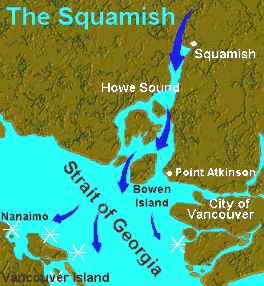
The broad arctic air flood is channelled down the coastal river valleys and through the fjords, usually producing gale-force arctic outbreak winds. Racing like rivers rushing down to the sea at speed often as high as 110 km/h (70 mph) with extremes to 185 km/h (115 mph), outbreak winds can be very damaging. Some even earn themselves a distinctive name. The most well-known arctic outbreak wind on the British Columbia coast bursts out of Howe Sound, past Bowen Island and onto the Strait of Georgia. Locals called it the Squamish after the small town that lies at the head of the sound's inlet.
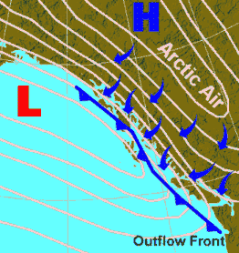
The arctic outbreak front signals the advancing boundary of the cold air. While the air pressure may not drop prior to the outbreak front, as usually happens with cyclone-associated cold fronts, it jumps rapidly with the outbreak front's passage, signifying the arrival of the dense, cold air. This cold front is often associated with the heaviest weather.
Arctic outbreaks bring extreme weather to the continental coast, coastal waters and the offshore islands, particularly those small islands in the Georgian Basin between the continent and Vancouver Island. Common conditions associated with arctic outbreaks include gale or storm force winds, moderate to heavy snowfalls and squalls, and over the waters, severe icing, high waves, rough seas and poor visibility.
Sea Smoke off Antarctic Waters Photo Courtesy of NOAA/US Dept of Commerce
Visibility is reduced by the snow showers and squalls, and by sea smoke, which forms when air with temperature below -14 oC (10 oF) cross warm sea waters. Generally, sea smoke is confined to a layer above the sea surface a metre or two (3 to 7 ft) in depth, but it may be much deeper and thick enough to reduce visibility to near zero.
On western continental shores and over the ocean water, snow flurries induced by the outbreak front will end shortly after it has passed, and clear skies generally prevail throughout the remainder of the outflow period. Strong, and often chaotic, offshore winds dominate the strong outflow period as the cold air pushes through the rugged terrain and around topographical obstacles. Therefore, the outflow winds can produce heavy and unpredictable local sea states which can be hazardous to mariners around the rugged coast.
Along the eastern shore of Vancouver Island and on the smaller islands off its inner coast, arctic outbreaks can form sea effect snow squalls similar to the lake effect snows found along the lee shores of the Great Lakes. The frigid arctic air moving across the relatively warm sea waters receives heat and moisture from below that enhance convective cloud formation in the cold air mass. These clouds then produce snow showers when they reach the islands. Prolonged snowfalls associated with arctic outbreaks often account for the only significant snow accumulation that the lower elevations on southern and central Vancouver Island see during a winter.
Should the arctic air encounter extensive moisture moving over the coastal region from an offshore storm system, snowfall may be extremely heavy, accumulating to great depths similar to that which fell during Victoria's Big Snow of 1996.
And should a large frigid air mass become firmly entrenched over the southern British Columbia Interior, it may persist for days. Persistent cold air flow off the continent onto the offshore waters and island bring another outflow: a stream of discouraging words from the region's residents unaccustomed to such wintery conditions.
Learn More From These Relevant Books Chosen by The Weather Doctor
For More Weather Doctor articles, go to our Site Map.
I have recently added many of my lifetime collection of photographs and art works to an on-line shop where you can purchase notecards, posters, and greeting cards, etc. of my best images.


 Should the arctic air encounter extensive moisture moving over the coastal region from an offshore storm system, snowfall may be extremely heavy, accumulating to great depths similar to that which fell during Victoria's Big Snow of 1996.


 Winters along the northern Pacific coast of North America -- particularly British Columbia and the Alaskan Panhandle -- are much milder than its latitude (49-62 deg N) would indicate. The prime factor for the moderate temperatures is the influence of Pacific Ocean waters. The thermal inertia -- the slow response of the great water volumes to solar and atmospheric heating -- of the Northern Pacific waters results in a moderating influence on air temperatures that produces a small annual temperature range (and with seasonal extremes coming later than at interior sites). As a result, winter temperatures at sea-level stations on the mainland shoreline and many offshore islands average only a few degrees off the freezing mark.