| Home | Welcome | What's New | Site Map | Glossary | Weather Doctor Amazon Store | Book Store | Accolades | Email Us |
 | |||||||||||||||||||||||||||||||||||
Weather Almanac for September 2009WEATHER SATELLITES AND TROPICAL STORMSOver the last century and a half, a handful of inventions from outside the discipline of meteorology have provided major stepping stones for the development of weather forecasting. The first, and perhaps foremost in my opinion, was the telegraph and its connecting networks. They allowed the gathering of weather observations from around a large area for use in near real time to construct synoptic weather charts. Similarly, wireless communications — voice radio or data transmission — sped up the process and provided for the inclusion of sites not on linked to a ground telegraph network, such as ships at sea. Radio technology also became instrumental in collecting vertical profiles of the atmosphere via the radiosonde.
During the first half of the 20th Century, at least three tropical storm events made an important impact on US history. The first was the Galveston Hurricane of 1900 (yes, I know technically this was the last year of the previous century) which took as many as 10,000 lives, the greatest death toll by natural disaster in the US. The second was the 1935 hurricane, which struck the Florida Keys and took over 400 lives. The third, the Great New England Hurricane, struck in 1928 and left 680 dead in its wake and widespread damage. What I take as a common element from these three “modern era” storms is that for a critical time prior to their striking the US coast, these storms were “lost” or mislocated in their position offshore which, in part, hampered adequate warnings on the part of US Weather Bureau. I add two related event in the western Pacific Ocean to this list: the encounter of the American Pacific Naval Fleet under the command of Admiral William F. “Bull” Halsey with two typhoons within six months. Each inflicted heavy damage to the fleet and a significant loss of life. In each case, had satellite reconnaissance been available, many lives would undoubtedly have been saved. Because tropical cyclones form at sea and often spend much of their existence over remote oceanic areas (particularly in the Pacific Basin), detection and continual monitoring of tropical storms have long posed serious problems to the storm forecaster. With the advent of weather satellites, and particularly the geostationary satellites, the problem of quick detection and continuous monitoring of these storms has largely been solved.  In the remaining portions of the Almanac, I look at some of the history and accomplishments of satellite meteorology as it views tropical storms across the global oceans. The BeginningsEarly in its mandate, NASA had identified weather forecasting as the most promising application of space-based observations. The TIROS (Television Infrared Observation Satellite) program was NASA’s first project to determine if satellites could be useful in the study of the Earth’s weather. Therefore, the TIROS Program’s first priority was the development of a meteorological satellite information system. According to NASA: “The goal was to improve satellite applications for Earth-bound decisions, such as ‘should we evacuate the coast because of the hurricane?’.”
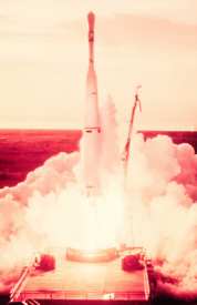
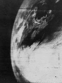
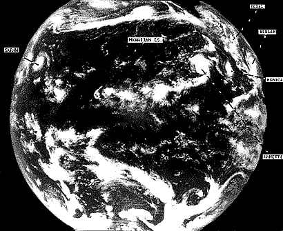
The first dedicated satellite for weather observation TIROS-1 obtained earth orbit on 1 April 1960 and operated for 78 days. A polar-orbiting satellite, TIROS-1 proved that weather observations from space could be a useful tool to meteorologists. Our story of weather satellites observing tropical storms, however, really begins with the launching of TIROS-3 on 12 July 1961. TIROS I also detected a tropical cyclone in the waters of the South Pacific north of New Zealand, an area which had to rely on ship and aircraft reports to indicate the formation and presence of storms at sea.
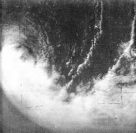
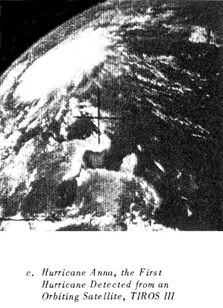
Although TIROS-3 lost one of its camera’s twelve days after launch, the other provided excellent imagery during the remaining days of the satellite’s mission (NASA deactivated it on 28 February 1962). TIROS-3 officially became the first weather satellite to observe a hurricane when it snapped images of Hurricane Anna on 21 July 1961. (Back analysis suggests that TIROS-3 may have observed early stages of the storm four days earlier.) The potential for hurricane observation by satellite became apparent when TIROS-3 sent back images of other hurricanes that season. In September its images showed the classic hurricane structure of Betty and Carla, one of the most intense and destructive hurricanes ever to strike the US Gulf Coast.
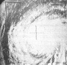
Hurricane forecasters used TIROS-3 to track Hurricane Debbie (6-16 September) in its early development when it formed near the Cape Verde Islands outside the range of the reconnaissance aircraft. Initially they had assumed a storm path based on climatology but through the satellite images determined it actually took a more northerly path. Debbie never approached North America, crossing over the Azores before reaching the Irish Coast. TIROS-3 imagery next detected tropical storm Esther, perhaps already at hurricane strength on 10 September, two days prior to its detection by aircraft: the first tropical storm to be initially detected by satellite. In the summary of the 1961 Hurricane Season published in the March 1962 issue of Monthly Weather Review, Gordon E. Dunn noted: “Some of the weather satellite potential in hurricane detection and tracking was demonstrated in 1961.” TIROS-4 launched on 8 February 1962 obtaining the best images to date, and the US Weather Bureau initiated an international facsimile transmission network to share the imagery with weather services around the world. TIROS-5 and TIROS 6 (launched 19 June and 18 September, respectively in 1962) both played important roles in the 1962 Atlantic hurricane season. In fact, NASA moved up the launch of TIROS-6 by two months in order to assist TIROS-5 in helping produce accurate storm forecasts during that hurricane season. In a posthumous article published in 1965, Harry Wexler, considered the father of weather satellites, wrote: “The TIROS satellites disclosed the existence of storms in areas where few or no observations previously existed, revealed unsuspected structures of storms even in areas of extensive observational coverage, depicted snow fields over land, ice floes over water, and temperature patterns on land and ocean as well as temperatures of tops of cloud layers.” The TIROS satellites began continuous coverage of the Earth’s weather in 1962, and meteorologists worldwide used their images in weather analyses and forecasts. The program's success with a variety of instrument types and orbital configurations led to the development of more sophisticated meteorological observation satellites. The TIROS spacecraft series began a long series of polar-orbiting meteorological satellites. NASA followed TIROS with the TOS (TIROS Operational System) series, and then the ITOS (Improved TIROS) series, and later the NOAA series of satellites. These were the mainstay of weather observations until the GOES series came into operation in 1975. Following the success of TIROS, NASA, the Environmental Science Services Administration (under which the US Weather Bureau was administered) and the National Meteorological Center initiated the ESSA Satellite Program. Like TIROS, the nine ESSA satellite’s primary objective was to provide cloud-cover photography. ESSA particularly targeted hurricanes and cyclones from their earliest development and movement to their dissipation. Over a period of seven years, ESSA satellites transmitted thousands of images back to Earth, many enabling forecasters to predict hurricane/typhoon movements.
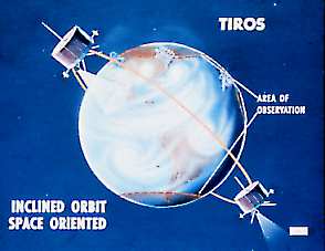
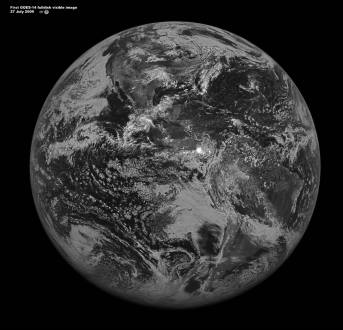
The Geostationary SatellitesThe polar (orbits paralleling the meridians) and oblique (orbits crossing the meridians) orbiting satellites, while extremely useful in weather observation, had one major shortcoming. They did not provide continuous and full coverage of storms, capturing only swaths of the storm as they passed overhead and providing no coverage for extended periods as the satellite’s orbital view swept across the globe. The development and deployment of geostationary satellites solved this. Science fiction author and futurist Sir Arthur C. Clarke first put forward the concept of geostationary satellites for communications well before the first useful artificial moons were launched. He described the concept in a paper titled "Extra-Terrestrial Relays — Can Rocket Stations Give Worldwide Radio Coverage?", published in Wireless World in October 1945. Geostationary satellites are placed in an orbit high above the Earth’s equatorial region at approximately 35,800 km (22,200 miles). Though the satellites are actually racing around the planet at great speed, they do so in step with the rotation of the planet’s surface below and thus remain over the same point at all times. The drawback to such orbits is that detail about the polar regions are poor or absent, but for the purposes of tropical storm detection and monitoring, such orbits are perfect. The ATS-1 (Applications Technology Satellite-1) obtained the first full hemisphere images of Earth in December 1966. ATS-1 was not in a geostationary orbit and drifted slowly westward over the tropical zones but it provided the biggest picture coverage to date with each scan.
For the past 35 years, the GOES (Geostationary Operational Environmental Satellite) system has provided crucial images for forecasters around the globe. The first geostationary weather satellite (GOES-1) was launched on 16 October 1975. The advantages of geostationary orbits proved themselves extremely useful to weather forecasters, and GOES-1 quickly became a critical part of the US National Weather Service. The latest of the NASA/NOAA geostationary weather satellites, GOES-14 was launched on 27 June 2009 as GOES-O. Upon reaching a geostationary orbit on 7 July, it was redesignated GOES 14. After testing, NASA scientists will place it in a standby orbit until needed. The first GOES-14 visible full disk image, taken on 27 July 2009 at 2:00 pm EDT, showed little tropical activity in the Atlantic Ocean and two tropical waves located in the East Pacific Ocean with a low probability of becoming a tropical cyclone.
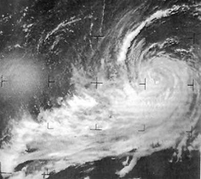
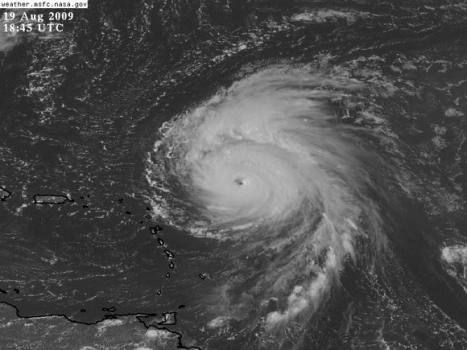
Conditions were quite different a few days later. On 17August 2009, GOES-14, returned its first full-disk thermal infrared (IR) image. In the left-hand side of the image, we can see Hurricane Bill. Tropical Storms Ana and Claudette are also visible in the western Atlantic Ocean and Gulf of Mexico, respectively. Three days later Bill was a Category 4 storm on its way to Bermuda.
More Than Cloud ImageryWhile the first weather satellites returned only images using the visible portion of the electromagnetic spectrum, succeeding satellites began viewing the Earth and its atmosphere in other wavelengths as well. Visible imagery is mostly constrained to the daylight hours. The addition of infrared imagery overcame the need for sunlight, and thus observations of sky conditions could continue through the night.
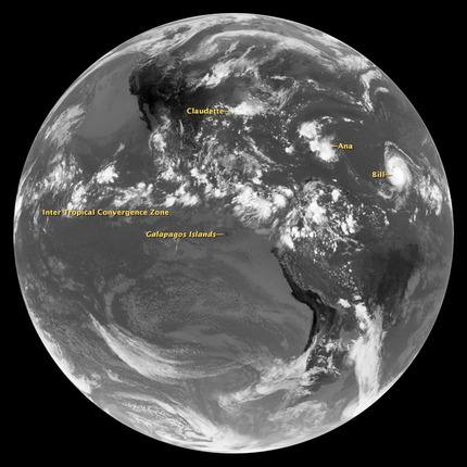
I have not the space to describe each new development in satellite sensing of weather in detail, but in this sidebar article I discuss a few of the more useful techniques now employed. Research continues to seek new and improved remote sensing systems to fly on satellites for the purpose of strengthen the prediction and tracking of hurricanes. NOAA and NASA are planning the next generation of satellites (GOES-R) that they expect to bring key improvements in predicting severe weather, including hurricanes. GOES-R observations should result in longer lead times for both storm watches and warnings, and they should better define the area under threat from hurricanes and other dangerous weather. The first launch of the GOES-R series satellite is currently scheduled for 2015. No More SurprisesKerry Emanuel, author of Divine Wind: The History and Science of Hurricanes, has written, “Tropical cyclone detection rates have been close to 100% globally since around 1970, when global satellite coverage became nearly complete.” 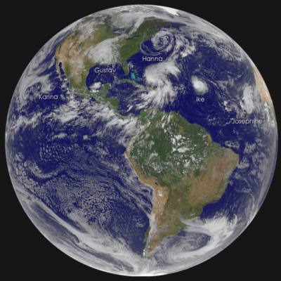 September 3, 2008 GOES image acquired at 1:45 PM EDT that shows five tropical cyclones.
|
|||||||||||||||||||||||||||||||||||
 |
 |
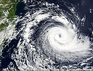
Hurricane Catarina in the South Atlantic |
Hurricane Catarina in the South Atlantic |
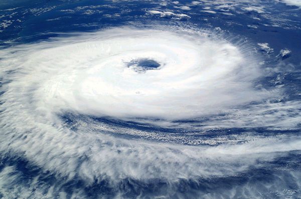
Satellite imagery and remote sensing from both geostationary and polar-orbiting satellites currently provide great assisted in the operational forecasting of tropical by nearly pinpoint location of a storm’s position and intensity. “Being able to predict the path of a hurricane with reasonable certainty and only evacuating the areas at risk saves communities roughly a million dollars per mile,” remarked Thomas Renkevens, User Services Coordinator from NOAA’s National Environmental Satellite, Data and Information Service. As a result, coastline and island populations in the tropical storm zones should no longer fear the surprise approach of one of the greatest storms on earth.
 |
To Purchase Notecard, |
Now Available! Order Today! | |
 |
 |
Now |
The BC Weather Book: |


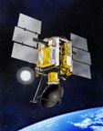
 Following the Second World War, products of the war machine opened new avenues of meteorological observation and analysis with the rise of radar, digital computers and rocketry. The latter led to Earth-orbiting satellites for weather observation, which are the central focus of this Almanac, with particular emphasis on their role in detection and tracking of tropical storms.
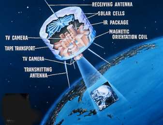
 In the five decades since the TIROS-1 launch, weather satellites have carried more and more sophisticated remote sensing devices that allow meteorologists to delve into the anatomy of tropical storms. The results derived from experiments using these sensing techniques have provided improved tools for tropical storm forecasters, and, consequently, tropical storm forecasts and warnings have improved dramatically. Since the beginning of the space age, more than 200 weather satellites have been launched by nations around the world to monitor weather and many have the ability to keep a weather eye on those deadly tropical storms that roam the world’s oceans.