Weather Almanac for October 2005
WHEN WEATHER GOES BAD:
HURRICANE KATRINA

August 29, 2005: the date happened to be my 58th birthday and it appears that it will be one I will always remember, though not for the usual reasons.
Anyone who loves nature, and the many powerful forces that are part of its majesty, take the risk that the beauty one sees in a given area of interest may turn bad. Dogs, crocodiles, tigers, etc. can kill; it is in their nature. The sea, the rocks of the Earth and the weather too can become killers, though they do so with no intent. People, other life forms and property just happened to get in their way. So it was with the Category 4/5 hurricane we named Katrina.
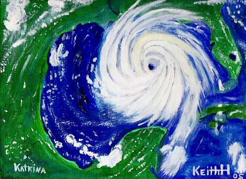
Peaceful From Above
Hurricane Katrina Dominates the Gulf
28 August 2005
Original Oil Painting by Keith C. Heidorn
I look at severe storms from many perspectives: a lover of the power and awe of a storm's fury and its images; a scientist who wonders about why and how and what will come next; and a consultant who has opinions on how we humans can cope with the forces nature throws at us. And above this, I also look at the impacts of severe storms from a compassionate perspective. I have know at very close hand what violent weather can do . . . although I have never been subject personally to the weather's most violent fits (tornadoes or powerful tropical storms).
But I am not totally untouched by Katrina though I dwell thousands of miles away, and I don't mean those secondary effects of higher gasoline prices and potentially higher insurance rates. No, it is more personal. I have a friend and classmate from my days at the University of Michigan who lives in New Orleans. Bob Zabrecky, aka Bob Breck, works as one of the top weathercasters in that city and lives north of the downtown and south of Lake Pontchartrain. I hope he and his family came through it all right, though I imagine he, as a dedicated meteorologist, stayed to the last moment to ensure his listeners were as well informed as they could be. (An email from him confirms that statement.)
In their book on tornadoes Under the Whirlwind, authors Arjen and Jerrine Verkaik include an essay "Magnificent or Monstrous" that articulates the dilemma of those of us who take a strong interest in severe storms: "...do we view them as destructive, unwanted threats or as rare, beautiful treasures of nature?" They further write (though written about the tornado, please substitute hurricane or any similar natural disaster here if you wish): "It [the tornado] is a mirror to our own limitations and vulnerability, a lesson in humility and the grander principles in nature."
In Perils of a Restless Planet, Ernest Zebrowski, Jr warns us about the dangers of natural disasters: "Natural disasters, on the other hand, are by nature unpredictable; they kill and destroy because they catch people by surprise. We grasp at the little straws Mother Nature supplies."
Obviously, catching us by "surprise" is the key here. To not be caught by surprise, the Dutch have put much thought and engineering into the construction of the dikes that hold back the North Sea and the waters of two large rivers, the Rhine and the Meuse that wind their ways through Switzerland, Germany, France and Belgium before they reach the Netherlands and the sea. Like New Orleans, most of the Netherlands lies beneath sea level. The last major flooding threat occurred there in January/February 1995. Believing the situation to be critical, the authorities decided on evacuation. In a few days, some 250,000 people, 300,000 head of cattle, a million pigs, and millions of poultry birds were removed from the danger zone. The dikes held, the water level peaked just short of their tops, and the potential catastrophe was averted. Luck or sound planning? Perhaps both, though I lean heavy on the planning. In the case of New Orleans, there appears to have been neither extensive planning nor luck.
On the other hand, Katrina's coming was not unheralded. The US National Hurricane Center had issued Hurricane Watches for much of the effected area days in advance and warnings when appropriate. The thought that so many were caught in the storm's fury with that much warning sends a chill up my spine. What would have happened with no warning, or but minutes warning?
But we go on and we move on. My mother asked me "Should New Orleans be rebuilt?" My answer is yes, but with the proviso that we use the massive knowledge along with the great wealth in the hands of the United States. The nation learned from the Chicago fire, the San Francisco earthquake, the Galveston hurricane and other natural disasters, and they rebuilt more wisely. But why does it take such a great devastation to move to actions often foresee decades before? The United States has known about the flooding threat to New Orleans for at least 68 years and the potential threat of flooding and hurricane for many decades. Why has the nation undertaken to rebuild Germany, Japan and now Iraq yet shirks its duty at home? That is the second great tragedy of this storm.
A Quick Look at Katrina
It has been only about a month since Hurricane Katrina hit the Gulf Coast after crossing south Florida days before. As I write this piece (days before it will be posted), Hurricane Rita is passing the Florida Keys and headed into the Gulf, destination as yet unknown. May the powers of nature spin it away from the Louisiana–Mississippi–Alabama coasts.
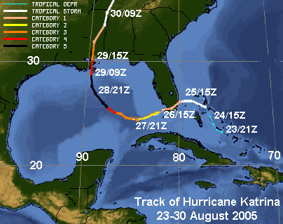
Tracking Chart for Hurricane Katrina
Data courtesy the US National Hurricane Center
As we look at Katrina without much extra analysis so close to the event, here are some of the facts about the storm courtesy of the US National Climatic Data Center (for full report, click here: [http://www.ncdc.noaa.gov/oa/climate/research/2005/katrina.html])
"Hurricane Katrina was one of the strongest storms to impact the coast of the United States during the last 100 years. With sustained winds during landfall of 140 mph (225 km/h) — a strong category 4 hurricane on the Saffir-Simpson scale — and minimum central pressure the third lowest on record at landfall (920 mb [27.17 inches Hg]), Katrina caused widespread devastation along the central Gulf Coast states of the US. Cities such as New Orleans, LA, Mobile, AL, and Gulfport, MS bore the brunt of Katrina's force..."
Hurricane Katrina developed as the twelfth tropical depression of the 2005 season near the southeastern Bahamas on 23 August. It strengthened into Tropical Storm Katrina the next day, then moved slowly first along a northwesterly path then a westerly track through the Bahamas. A few hours before crossing south Florida at around 6:30 (AM) EDT on 25 August, Katrina strengthened to become a Category 1 hurricane, making landfall between Hallandale Beach and North Miami Beach, Florida, with wind speeds of approximately 80 mph (130 km/hr) and gusts of above 90 mph (145 km/hr). The storm then moved southwest across the tip of the Florida peninsula.
Given that Katrina spent only seven hours over land, its strength was not significantly diminished. It quickly re-intensified to hurricane strength shortly after moving over the warm waters of the Gulf of Mexico. Katrina moved almost due westward then gradually turn to the northwest and north in the days that followed. Atmospheric and sea-surface conditions were conducive to rapid intensification, and Katrina attained "major hurricane" status on the afternoon of the 26th. As early as three days before Katrina pulverized the Gulf Coast, the National Hurricane Center warned that New Orleans lie in the Category 4 hurricane's path.
Continuing to strengthen and move northward during the next 48 hours, Katrina, now Category 5, reached maximum wind speeds on the morning of Sunday 28 August at 175 mph (285 km/h) with minimum central pressure that afternoon of 902 mb (26.64 inches Hg).
Katrina was a strong Category 4 hurricane as it made landfall on the morning ( 6:10 AM CDT) of the 29th. Wind speeds at Grand Isle, Louisiana measured approximately 140 mph (225 km/h) with a central pressure of 920 mb (27.17 inches Hg) — the third lowest on record for a landfalling Atlantic storm in the US. Winds gusted to over 100 mph (161 km/hr) in New Orleans, just west of the eye. As the hurricane made its second landfall on the Mississippi/Louisiana border, wind speeds were approximately 125 mph (201 km/h). Gusts of over 80 mph (130 km/hr) were recorded in Mobile, Alabama and 90 mph in Biloxi, Mississippi.
Storm surge from Mobile Bay led to inundation of Mobile causing imposition of a dusk-to-dawn curfew. Large portions of Biloxi and Gulfport, Mississippi slipped underwater as a result of a 20-to-30-plus foot (6.1 to 10 metres) storm surge which flooded these cities as Gulf of Mexico floodwaters spread several miles (kilometres) inland.
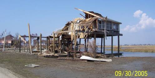
Storm Surge Damage from Hurricane Katrina
photo courtesy Dr. John Lipscomb, Jr., P.Eng.
As Katrina came ashore on 29 August, rainfall rates exceeded 1 inch/hour (2.5 cm/hour) across a large area of the coast. Precipitation analysis shows that rainfall accumulations exceeded 8-10 inches (100-200 mm) along much of the hurricane's path and to the east of the track.
Breaks in the levees that separate New Orleans from surrounding lakes worsened the loss of life and property damage. At least 80% of New Orleans was under flood water on 31 August with some parts under 20 feet (6.1 metres) of water, largely due to levee failures from Lake Pontchartrain. The combination of strong winds, heavy rainfall and storm surge led to breaks in the earthen levee after the storm passed.
From the Gulf states (principally Louisiana and Mississippi), the total loss of life is still unknown but has officially pushed over a thousand. Damage estimates at this time are staggering, in excess of $200 billion and will likely climb before the region is restored to some semblance of normal. In Florida, initial estimates suggest 11 deaths and from $600 million to $2 billion in damages.
The Aftermath
As Katrina sped northward into the Tennessee Valley then south of the lower Great Lakes dumping heavy rainfall along its course. Rainfall amounts exceeded 2-4 inches (50-100 mm) across a large area from the Gulf Coast to the Ohio Valley.
The cleanup continues and soon the rebuilding will start, but residents of the northern Gulf Coast do so while looking over their shoulders. Hurricane season has two-plus months to go and statistically, the warm waters of the Gulf of Mexico spawns many last season storms. We pray none decide to follow Katrina's path.
I hope all who read this are offering as much support as they can. If you have the resources, help organizations like the Red Cross pay for their efforts. You may need them in the future.
Learn More About Hurricanes From These Relevant Books
Chosen by The Weather Doctor
- McQuaid, John and Mark Schleifstein: Path of Destruction: The Devastation of New Orleans and the Coming Age of Superstorms, 2006, Hachette Book Group USA, ISBN:031601642X.
- Sheets, Bob and Jack Williams: Hurricane Watch : Forecasting the Deadliest Storms on Earth, 2001, Vintage Books; ISBN: 037570390X.
- Zebrowski, Ernest Jr and Judith A. Howard: Category 5: The Story of Camille — Lessons Unlearned from America's Most Violent Hurricane, 2005, ISBN 0472115251, Hardcover, 304 pages.
Written by
Keith C. Heidorn, PhD, THE WEATHER DOCTOR,
October 1, 2005
The Weather Doctor's Weather Almanac : When Weather Goes Bad: Hurricane Katrina
©2005, Keith C. Heidorn, PhD. All Rights Reserved.
Correspondence may be sent via email to: see@islandnet.com.
For More Weather Doctor articles, go to our Site Map.
I have recently added many of my lifetime collection of photographs and art works to an on-line shop where you can purchase notecards, posters, and greeting cards, etc. of my best images.
Home |
Welcome |
What's New |
Site Map |
Glossary |
Weather Doctor Amazon Store |
Book Store |
Accolades |
Email Us
|


|


