Weather Almanac for December 2005
NEWFOUNDLAND'S WRECKHOUSE WINDS

Last year (2004), the Canadian Oxford English Dictionary added one new word that happened to be a weather word. That word was Wreckhouse winds, defined as "extremely strong winds which blow across Cape Ray from the Long Range Mountains in Newfoundland."
Though Newfoundland is a hotbed for colourful terms to describe weather conditions, such as silver thaw, mauzy, misky, loggy, dwigh and scad, this particular term is not of local origin. Though a colourful term, Wreckhouse winds actually describes dangerous winds in a specific place: Wreckhouse, Newfoundland, and likely originated with Environment Canada weather warnings.
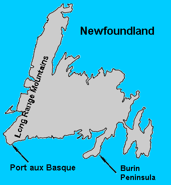
The Wreckhouse region lies along the southwest coast of Newfoundland between Cape Ray and St. Andrew's, north of Port aux Basques and within the valleys and gulches of the Codroy Valley below Table Mountain. A stretch of the Trans-Canada Highway now crosses the region, but it once was the roadbed for the Newfoundland Railway, and that is where our story begins.
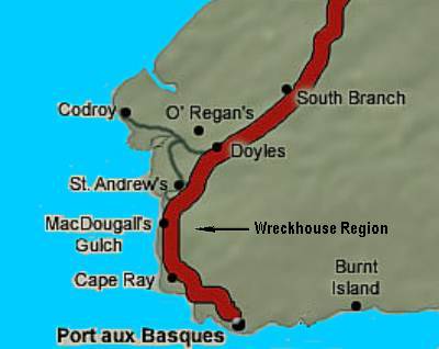
Wreckhouse Region of Southwestern Newfoundland
The Wreckhouse Phenomenon
Strong winds have always been a danger and part of Newfoundland's daily life. Newfoundland/Labrador ranks second among Canada's provinces and territories in the number of days annually with at least 1 hour's wind speed at or greater than 40 km/h (25 mph) and third for the annual average wind speed. So windy places on the island are far from rare.
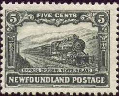 Prior to the coming of the railroad, most transportation around the island, affectionately known as "The Rock," was by boats moving along the coastline. Travel across the interior was uncommon until the 1880s when the Newfoundland Railway, the longest narrow-gauge railroad in North America, was built. It initially ran from St John's up the Avalon Peninsula in 1893, but later became a trans-island railway by crossing the northern island in a great arc that terminated at the ferry landing at Port aux Basque. The first passenger train crossed the island in June 1898, and regular passenger service continued until July 1969. The last freight ran in June 1988. Prior to the coming of the railroad, most transportation around the island, affectionately known as "The Rock," was by boats moving along the coastline. Travel across the interior was uncommon until the 1880s when the Newfoundland Railway, the longest narrow-gauge railroad in North America, was built. It initially ran from St John's up the Avalon Peninsula in 1893, but later became a trans-island railway by crossing the northern island in a great arc that terminated at the ferry landing at Port aux Basque. The first passenger train crossed the island in June 1898, and regular passenger service continued until July 1969. The last freight ran in June 1988.
In January 1900, a powerful storm struck the southwest region of Newfoundland. As the winds howled through the Table Mountains, Passenger Train No. 1 was headed to Port aux Basque. As it steamed through the Wreckhouse area, the gale blew the unsuspecting No. 1 completely off the tracks. Though no lives were lost, the mail and all the baggage were when the mail car caught fire.
After a number of similar mishaps and train delays over the following decades, the Reid Company, which had built the railway, suggested the roadbed be relocated to a less windy location. Their proposal was not accepted by the Newfoundland Government who balked at the cost, forcing the Reid Company to find alternative means to deal with the wind problem. (For readers not familiar with Newfoundland, it was not a province of Canada at this time, being an independent country from 1854 until 1949.)
So, for many years, the Reid Company simply coped with the winds along this section of track and accepted having occasional trains blow from the tracks. During the early 1930s, however, the Newfoundland Railway managers became aware of a local farmer and trapper named Lockland "Lockie" MacDougall (or "Lauchie" as some sources spell it). MacDougall had been born in the Wreckhouse region in 1896 where his family had set down roots in the area during the 1870s and would live there his entire life. According to their reports, Lockie had a weather sense that gave him the ability to read the signs of an approaching storm and the intense winds that accompanied it.
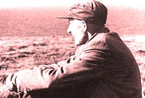
Lockland "Lockie" MacDougall
Photograph courtesy National Archives of Canada
The Newfoundland Railway decided it was worth a shot and agreed to pay him as an observer — a "human wind gauge" — the premium sum of $20 a month to warn the nearby Port-aux-Basques rail office of the onset of extreme winds. This allowed the railway managers to halt trains before they reached the dangerous Codroy Valley section of track. They then held east bound trains in the shelter of the railyard and west-bound traffic in the safer regions in the Codroy Valley.
Reportedly, on one occasion the conductor of a train decided to ignore Lockie's "forecast" and continued through the valley. When 22 cars of that train were blown off the tracks by the Wreckhouse winds, McDougall's stature rose and he became a local legend. He provided the warnings until his death in 1965. His wife Emily then continued the service until 1972 when she moved way. Lockie is credited with delaying hundreds of trains over the years because of treacherous wind conditions and likely saved many lives and much property.
The legend of Lockie McDougall lives on the Wreckhouse region and is commemorated by a bronze plaque at the Marine Atlantic Terminal in Port aux Basques: "This plaque is dedicated to the memory of Lauchie McDougall (1896-1965). McDougall had extraordinary skills in determining wind velocities � through this area. Often called the �human wind gauge,' McDougall provided this service to the railway for over 30 years." For some time, his empty home stood along the Trans-Canada Highway, the Environment Canada remote anemometer rising beside it to monitor the Wreckhouse winds.
When the railway closed, commercial road traffic increased along the Trans-Canada Highway that parallels the old railbed. Transport trucks, however, are even more vulnerable to strong winds than railcars, and many have been toppled or pushed into the ditch over the years. During the stormy Newfoundland winter, drivers along this highway often face the fury of the Wreckhouse winds and decide whether to delay their journey or push through and hope for the best.
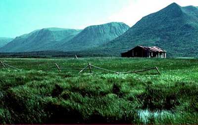
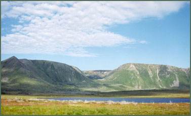
Wreckhouse Region of Southwestern Newfoundland
Photographs courtesy of Geological Survey of Canada, Natural Resources Canada
Although Environment Canada and other forecast providers issue special wind forecasts and warnings for the Wreckhouse region, that was little comfort to many residents of southwestern Newfoundland recently as they faced the prospect of traversing the Wreckhouse to obtain surgical and obstetric health services at Corner Brook hospitals.
Steve McKenzie, who has operated ambulance services in rural Newfoundland for more than 20 years, knows blizzards in the Codroy Valley area are often too risky for drivers even in emergency situations. "We're at the mercy of Mother Nature out here, there's no more than that to it...It's legendary in this area. It's like living in a flour sack. You can't see sideways, you can't see out through your front windshield. It's just amazing."
Transportation is not the only thing vulnerable to Wreckhouse winds. Homes and farm buildings in the Codroy Valley often feel the wrath of Wreckhouse's powerful winds, losing siding and roofs.
The Causes of the Wreckhouse Winds
We know Newfoundland is generally a windy place, but what makes the Wreckhouse region so special?
 The first factor is that strong winds are common in southwest Newfoundland during any time of the year; however, they become more frequent and of higher velocity during the winter and spring when strong Atlantic storms slam into the island. When intense storm systems approach Newfoundland from the south (often as coastal Nor'Easters), the circulation around the low pressure centre commonly brings strong southeasterly winds ahead of it. Along the southern Newfoundland coast from west of the Burin Peninsula toward Port aux Basques, those southeasterly gales converge along the coastline, channelled by the interior highlands. As a result, the wind gusts over land often exceed the wind speeds over open waters. The first factor is that strong winds are common in southwest Newfoundland during any time of the year; however, they become more frequent and of higher velocity during the winter and spring when strong Atlantic storms slam into the island. When intense storm systems approach Newfoundland from the south (often as coastal Nor'Easters), the circulation around the low pressure centre commonly brings strong southeasterly winds ahead of it. Along the southern Newfoundland coast from west of the Burin Peninsula toward Port aux Basques, those southeasterly gales converge along the coastline, channelled by the interior highlands. As a result, the wind gusts over land often exceed the wind speeds over open waters.
As the winds approach the southwestern corner of the island, they meet the Long Range Mountains, the highest range on Newfoundland. This mountain range forms a barrier to the wind flow that forces the air to accelerate over the ridge line and through the valleys and gulches, particularly around Table Mountain, an impressive 518-metre (1700ft) mountain with a rather flat summit where the American military set up an air strip and radar station during World War II. The air flow around and against the terrain produces gap winds which accelerate like water through a hose nozzle. Gale to hurricane-force winds sweep downslope from the ridge summits through the narrow valleys and stunted forest at speeds that can gust in excess of 160 km/h (100 mph), the equivalent to a Category 2 hurricane. It is at the end the Codroy Valley that the flat, barren-land of the Wreckhouse region, north of Port Aux Basques, is located.
Hike Through the Wreckhouse
Today, the Newfoundland Railway bed has become the Newfoundland T'railway, the Province's gateway for the Trans Canada Trail. A 24-km (15 mile) section of that T'railway, the Wreckhouse Trail runs from Port aux Basques to MacDougall's Gulch. Running along through the west facing slopes of the Long Range Mountains, the hiker can get a chance to view, but hopefully not experience, the home of the Wreckhouse Winds.
The Wreckhouse T'railway
Photograph courtesy of Newfoundland T'Railway Council
A final Newfoundland note. Leave it to those ingenious Newfies to take something bad and turn it good. Now, not all Wreckhouse winds are bad air. Three Newfoundland musicians Michelle Cheramy, Flute, Sean Rice, clarinet and saxophone and Maureen Volk, piano, have formed a musical ensemble that explores the classical repertoire for the flute and clarinet. Their name? The Wreckhouse Winds.
Photographs courtesy of Newfoundland T'Railway Council/Geological Survey of Canada, Natural Resources Canada/National Archives of Canada
Written by
Keith C. Heidorn, PhD, THE WEATHER DOCTOR,
December 1, 2005
The Weather Doctor's Weather Almanac Newfoundland's Wreckhouse Winds
©2005, Keith C. Heidorn, PhD. All Rights Reserved.
Correspondence may be sent via email to: see@islandnet.com.
For More Weather Doctor articles, go to our Site Map.
I have recently added many of my lifetime collection of photographs and art works to an on-line shop where you can purchase notecards, posters, and greeting cards, etc. of my best images.
Home |
Welcome |
What's New |
Site Map |
Glossary |
Weather Doctor Amazon Store |
Book Store |
Accolades |
Email Us
|


|


