| Home | Welcome | What's New | Site Map | Glossary | Weather Doctor Amazon Store | Book Store | Accolades | Email Us |
 | |||||||||||||||||||||
Weather Almanac for August 2005FLASH FLOODOften in late summer rainfall seems to be in short supply as lawns and crops whither under oppressive heat. Then one day, the situation does an about-face and it is a situation of "water, water everywhere" as the heavens burst forth in torrential rains. And with such short-term, intense rains comes a great danger: flash floods. Summer rainfall across much of North America generally falls in intense showery bursts rather than long, steady rains, and often the monthly total accumulates on just a few days during the month. While the hit and miss aspects of summer rainfall can be maddening to the farmer or gardener since much of the rainfall runs off the land rather than soaking in, large volumes of rain falling in a short time can be quite dangerous. The potential for flash flooding is high during these situations. At times, these flash floods turn deadly. In the United States, flood-related deaths usually exceed all annual weather-related deaths except for periods of high heat and extreme cold.
FloodsFlooding, in general, is the condition when water rises to overflow its natural or artificial confines — usually a stream, river, or other body of water — or fills low-lying terrain. It can be caused by a short-term precipitation event, long-term rainfall accumulation, rapid snowmelt, the breaking of debris or ice dams, storm surges, or tsunamis. Meteorologists and hydrologists distinguish six basic types of flooding: regional floods, flash floods, ice-jam floods, storm-surge floods, dam-failure floods, and mudflow floods. The traditional type regional flooding arises when days of heavy rains or rapid snow melt cause rivers and streams to overflow their banks, allowing water to move onto the surrounding flood plain. Such floods usually build and recede over a span of days or longer. With modern analysis and forecasting tools, such floods are usually well foreseen, minimizing the potential for human fatalities, though the death of wild and domesticated animals and destruction of property cannot always be avoided.
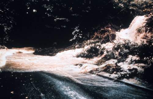
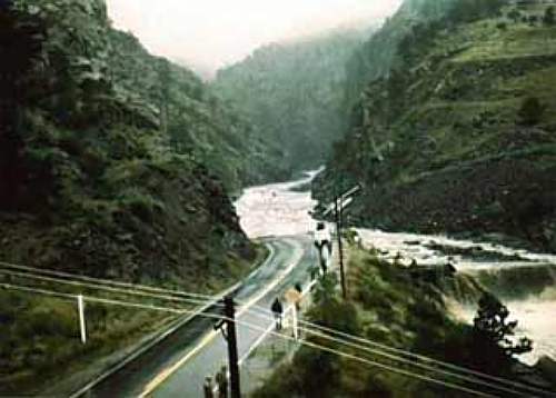
Flash flooding, on the other hand, commonly result from short, intense rainfalls over a small area, occurring over a few hours, usually six or less. Flash floods may also occur when heavy snowfall is followed by rapid melting and perhaps additional rainfall. The potential for flash flooding can often be predicted but not with the accuracy in time or space, or the long lead time, of traditional flooding warnings. Flash FloodsFlash floods occur in regions where the fall of rain exceeds the underlying surface's ability to remove it by absorption into the undersurface. In mountainous terrain, flash floods are of greatest hazards in small stream channels or canyons which drain a large area that is often devoid of vegetation. Often, the worst-case situation occurs when a thunderstorm stalls over a small patch of mountainous terrain with steep drainage channels and a rocky or frozen surface and dumps many centimetres of rain over a short time. Unlike other weather threats, flash floods are often initiated by human alterations to the nature of the landscape. As a result, flash-flood forecasting is a hybrid of disciplines, calling for knowledge of hydrology and topography as well as meteorology. By their very nature, flash floods are highly local events, which often makes it impossible to pinpoint their occurrence far in advance. However, meteorologists can often spot large-scale patterns that could yield extreme rainfalls that might cause flash flooding some 12 to 24 hours in advance. In addition to the dangers of rapidly rising waters, flash floods may carry heavy debris as they speed downslope. These roaring torrents contain boulders and plant debris — mostly tree trunks, limbs, and branches — followed by a liquefied mass of sediment and organic matter in the swift surge. Debris torrents are of particular concern in lowlands surrounded by high, steep mountains and in regions where extensive clearcut logging or surface mining has stripped vegetation which would absorb much of the rainfall. Since flash floods often strike with little warning in a small area, they can catch people unaware of the impending danger. It is important to be aware of flood hazards wherever you live, especially if you live in a low-lying area, near water, or downstream from a dam of any type. Very small streams, gullies, creeks, culverts, dry streambeds, or low-lying ground that appear harmless in dry weather can quickly flood in an intense rainstorm.
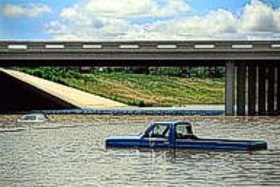
Even urban and suburban areas are at high risk from flash flooding. There, rain, falling on impenetrable concrete and asphalt surfaces, exceeds the storm sewer capacity to remove the water. Such flooding is often short term — the water draining quickly once the rain slows or stops — but it can be especially dangerous to drivers and pedestrians. Flash Flooding and VehiclesFlash floods kill more Americans annually, about 100 per year, than tornadoes, hurricanes, or lightning, and statistics show about sixty percent die in vehicle-related accidents. The majority of those deaths occur when victims are trapped in a vehicle swept away by rapidly flowing flood waters, even in urban areas. Urban flooding can quickly turn streets into swiftly moving streams where motorists struggle to control their vehicles. Most drivers — and pedestrians — underestimate the power of moving water. At a walking speed of 6 km/h (4 mph), flowing water exerts a force of 66 pounds/square foot against any object. A depth of only 15 cm (6 inches) can sweep you off your feet. A typical flood moves at 20 km/h (12 mph), giving nine times the force, and flash floods may exceed 95 km/h (60 mph) in narrow gaps.
The water's force is one factor that pushes vehicles off the road. Another is the vehicle's buoyancy: they will float. We consider cars heavy objects, but for each 30 cm (1 ft) rise in water level, their downward weight on the road decreases by around 680 kg (1500 pounds). At a depth of only 60 cm (2 ft), about up to the door level, moving water can easily sweep a car or light truck off a flooded roadway. Some road safety tips to consider when flooding dangers are present or impending:
Some Notable North American Flash FloodsOne of the most notable and deadly floods in American history was the great Johnstown (PA) flood of 1889. On 30 May 1889, a severe rainstorm descended on the Johnstown area and produced 150-200 millimetres (6-8 inches) of rain over a 24-hour period, enough to make Stony Creek and Little Conemaugh River flood over the banks. During the early hours of the following morning, the South Folk Dam collapsed and unleashed 20 million tons of water. A wall of water reaching 21 metres (70 ft) high swept down the river valley toward Johnstown, carrying away bridges, houses, livestock, and people. By early afternoon, the floodwaters had rushed intoJohnstown, crushing houses and downtown businesses. In 10 minutes, the city was completely wiped out, and over 2,200 people died.
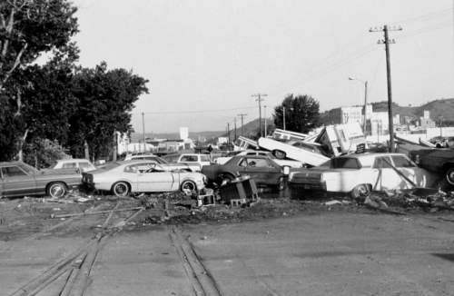
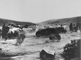
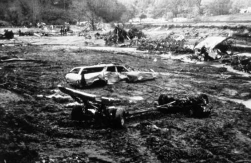
The next major flash flood occurred on 14 June 1903 at Heppner, Oregon, the state's most deadly natural disaster which took 236 lives. A strong thunderstorm brought heavy rain and hail over the the barren rocky hills in the basin of Willow Creek, a normally peaceful stream flowing through the town center of Heppner. (No rainfall measurements for this storm exist because the flood completely destroyed the weather-observing station, drowning the observer and his entire family.) At about 5 pm, the resulting flash flood, surging as a 12-metre (40-ft) wall of water, swept away the entire town in minutes, drowning nearly 220 residents. One-third of the town's structures were destroyed. Thirty-two kilometres (20 miles) downstream, the towns of Lexington and Ione were next. However, warnings to Ione prompted an immediate evacuation, and residents were able to escaped to high ground. The wall of water washed away 150 homes there. In the United States, the 1970s was the nation's worst decade for flash flooding. Three flash flood incidents took over 100 lives each. The first occurred on 26 February 1972 when a slag-pile dam collapsed under pressure of torrential rains (75-100 mm [3-4 inches]) overnight at Buffalo Creek, West Virginia. The rushing waters swept away houses and cars and caused 125 fatalities and $100 million in damages. On 9 June 1972, an afternoon thunderstorm complex stalled over the small drainage basin of Rapid Creek in the Black Hills of South Dakota. Over five hours, the system dumped around 380 mm (15 inches) of rain causing a debris flow downstream toward Rapid City. The debris temporarily clogged a spillway, backing up the waters which were suddenly released when the dam broke. The mass of water sent a flash flood across Rapid City. The flood killed 237 people, one of the deadliest flooding disasters in US history, and caused $164 million in damage. Four years later, a deadly flash flood swept down through Big Thompson Canyon in north-central Colorado, taking at least 139 lives. On the evening of 31 July, 1976, a tremendous thunderstorm formed over the Continental Divide near the headwaters of the Big Thompson River. In three hours, the storm dumped 300 mm (12 inches) of rain into the canyon. Sweeping 3-metre (10-ft) boulders before it, the wall of water raced down the canyon slope toward the highway and campgrounds filled on this night. Those in cars and campers in the torrent's path had no chance of survival. In two hours, the Big Thompson Canyon flood killed 145, including six persons whose bodies were never found, demolished 418 houses, damaged another 138, and destroyed 152 businesses. The damage estimate exceeded $40 million. The most significant flash flood in Canada resulted from the passage of Hurricane Hazel over the Toronto Metropolitan region. When Hazel crossed Lake Ontario late on the 15 October 1954, the ground was already saturated. The storm dumped around 210 mm (8.27 inches) of rain, most falling on the Humber River basin. On October 16, the Humber River's flow was four times greater than previously recorded. The torrent rushing down the Humber River struck with great force, completely shearing several bridges from their pilings. Where the swollen river met the floodplain, it quickly swept away nearly everything in its path. Where the Humber and Etobicoke Creek merged, the waters rose 6 metres (19.7 ft) in an hour. The debris from washed-out bridges diverted the river's wild, rushing waters onto Raymore Drive, carrying off a full block of one- and two-story cottages and the lives of 32 sleeping occupants. Sixty other families were left homeless, and 366 metres (1200 ft) of the street had disappeared. Heed the WarningsAdvances in flood science and forecasting abilities have greatly decreased the number of flash flood-related deaths in the past decades, but the system is not perfect as many such flood happen over small areas and more people venture out into rough terrain. Both the American and Canadian weather services offer watches and warnings when the potential for flash flooding exists. But it is also wise to be cautious when walking, cycling or driving in potential hazard spots such as streambeds and mountainous terrain. A few minutes may be all you have to save your life. The US National Weather Service will issue the following when conditions warrant: Flash Flood Watch: Indicates that flash flooding is a possibility in or close to the watch area. Those in the affected area are urged to be ready to take action if a flash flood warning is issued or flooding is observed. These watches are issued for flooding that is expected to occur within 6 hours after the heavy rains have ended. Flash Flood Warning: A flood warning issued for life/property threatening flooding that will occur within 6 hours. It could be issued for rural or urban areas as well as for areas along the major rivers. Very heavy rain in a short period of time can lead to flash flooding, depending on local terrain, ground cover, degree of urbanization, amount of man-made changes to the natural river banks, and initial ground or river conditions. Dam breaks or ice jams can also create flash flooding. Urban/Small Stream Flood Advisory: Alerts the public to flooding, which is generally only an inconvenience (not life-threatening) to those living in the affected area. Issued when heavy rain will cause flooding of streets and low-lying places in urban areas. Also used if small rural or urban streams are expected to reach or exceed bankfull. Some damage to homes or roads could occur.
Environment Canada issues severe weather warnings and watches and advisories to the public via the media, weather outlets and Weatheradio Canada. A flash flood alert may be released as part of a severe thunderstorm alert. Weather Watch: Alerts you that conditions are favourable for the development of severe weather. Watch the skies and listen for updated watches and possibly weather warnings. Weather Warning: alerts you that severe weather is occurring or that hazardous weather is highly probable. Severe thunderstorm or tornado warnings may be issued less than one hour in advance. Other weather warnings may be issued six to twelve hours in advance. Weather Advisory: means actual or expected weather conditions may cause general inconvenience or concern, but do not pose a serious enough threat to warrant a weather warning. An advisory may also be used when conditions show signs of becoming favourable for severe weather when the situation is not definite enough or too far in the future to justify a warning. Learn More From These Relevant Books
|
|||||||||||||||||||||
 |
To Purchase Notecard, |
Now Available! Order Today! | |
 |
 |
NEW! Now |
The BC Weather Book: |