| Home | Welcome | What's New | Site Map | Glossary | Weather Doctor Amazon Store | Book Store | Accolades | Email Us |
 | |||||||||||||||||
Weather Almanac for October 2004THEY CALLED IT HAZELThe year was 1954, and early in the year American weather officials agreed to continue the use of female names to distinguish Atlantic tropical storms and hurricanes, following a fairly successful use of the practice the preceding year. They proposed to repeat the 1953 list of names for 1954. Six hurricanes had arisen in 1953. Carol, the strongest hurricane (Saffir-Simpson Category 4), passed New England offshore before entering the Canadian Maritime Provinces and becoming extratropical. Seven hurricanes would develop in 1954 (this does not includes one very late season storm that formed in 1954 but became a hurricane in 1955). Carol of 1954 would not be as strong as Carol of ‘53, but its associated winds, rains and storm surge striking the American East Coast would cause sixty deaths and property damage estimated at $281 million ($1.93 billion in 2003 dollars), with more than half of that damage in North Carolina. At the time, it was the most expensive hurricane in US history. As a result, weather officials decided to retire the name of Carol, the first to be retired.
At the US Weather Bureau office in Miami — the center for hurricane forecasting at the time — chief forecaster Grady Norton sensed this storm might be the most dangerous storm of the year. Against the advice of his doctor, he continued to put in 12-hour days plotting and analyzing Hazel's course. The day, 9 October, Hazel took its deadly turn northward toward the major Carribean islands, Norton suffered a severe stroke and died a few hours later, leaving the Bureau meteorologists scrambling to continue his work. Norton's death cannot be directly attributed to Hazel, but by the time the storm itself had died along the eastern shores of Hudson Bay, three nations would be counting fatalities totalling perhaps more than 1000: Haiti (400-1000), the United States (95) and Canada (83). Crossing the CarribeanAfter gaining hurricane strength near the Windward Islands, Hazel sauntered westward toward 75oW along a line a couple hundred kilometres off the Venezuela coast. Late on 8 October, Hazel's winds reached 115 knots (213 km/h). On the 9th, the storm turned northeastward following a serpentine route that would cross the southeastern Bahamas on the 13th. Now a Category 4 storm, Hazel headed toward the Windward Passage separating Cuba from Haiti. Striking Haiti on the early morning of the 12th, Hazel devastated the nation with howling winds reaching 120 knots (222 km/h), and torrential rains and a high storm surge. Several small towns were almost totally demolished and the larger cities sustained severe wind damage. As in the impacts of Hurricane Jeanne in 2004, the incessant rains quickly rushed into the rivers and flash floods rolled downstream, destroying villages, bridges and road, homes and business, and crops. The death toll estimates ranged from 600 to 1000 people, and about 40% of the coffee trees and 50% of the cacao trees were destroyed, staggering the economy of this poor nation. After recovering from tussling with Haiti's western mountains that weakened the storm slightly, Hazel regained strength and forward speed as it crossed the southeastern-most Bahamian islands, particularly Great Inagua Island. Hazel now turned northwestward aiming toward the American coastline with the Carolinas in the bull's eye. Not So Fine In Caroline-aRevitalized, Hazel was again a Category 4 hurricane, and struck the US coast on 15 October. The eye passed about 152 km (95 miles) east of Charleston, South Carolina at 8 AM, the hurricane's fringes first making contact with the coast near North Island, SC. About two hours later, Hazel struck land at the South Carolina – North Carolina border, the third hurricane to affect North Carolina this season. The resulting storm surge was the greatest in North Carolina annals: 5.5 m (18 ft) above mean low water at Calabash, striking at the exact time of the highest lunar tide of the year. According to the report from the Raleigh Weather Bureau office: "All traces of civilization on that portion of the immediate waterfront between the [SC-NC] state line and Cape Fear were practically annihilated."
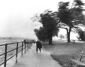
Winds caused major damage all across the eastern sections of North Carolina. They broke, toppled, uprooted, and tossed countless trees across the eastern state. In some sections, the number of trees littering the highways was estimated at hundreds per mile. Pine forests appeared as if scorched by fire. Roofs and television aerials took the hardest hit, but many radio transmission towers, billboards and drive-in theaters were also heavily damaged. Along the western quadrants of the hurricane, heavy rains and subsequent flash flooding caused even greater damage through the western Carolinas (and northward into Canada). As much as 300 mm (12 inches) of rain fell in the region; ten North Carolina climate stations set 24-hour total precipitation records that day. Before the flood waters receded, damage to property and dislocation of much of the state's population would increase the infamy of Hazel. After Hazel's passing, 20 people were reported dead or missing in the two Carolinas and property damage estimated at $441 million (2003$). At Myrtle Beach SC, 80 percent of the waterfront development, 273 houses, were destroyed. Ocean Drive SC lost 450 houses, and Cherry Grove Beach SC, 300 of 450 houses. Almost all coastal homes and buildings in Brunswick County NC were severely damaged or washed away. Long Beach NC (now Oak Island) lost 352 of 357 buildings; Holden Beach NC lost all 200. Damage to North Carolina's beach resorts alone exceeded $247 million (2003$). North To Canada
During its sprint northward, Hazel continued to dump tropical rains along its western track, totals as high as 300 mm (12 inches). And with its winds continuing to blow strong at or near hurricane strength, Hazel toppled trees and flooded communities through Virginia and all the way up to the Canadian border. Wind gusts to 87 knots (160 km/h) were recorded from numerous locations in Virginia, Maryland, Pennsylvania, Delaware and New Jersey, and as far inland as upstate New York. By 11 pm on the 15th, Hurricane Hazel had reached and crossed the waters of Lake Ontario, still sporting sustained winds as high as 52 knots (112 km/h). Its traverse across American soil left 95 dead and damage estimated at $281 million, or $1.93 billion in 2003 dollars. Hurricane Hazel in OntarioIn southern Ontario, the autumn's rainfall preceding Hazel's arrival had been unusually heavy. When Hazel crossed Lake Ontario on the 15th, Toronto residents had already suffered through several days of heavy rain and wind, and the ground was saturated. The cold front that had produced the latest round of rains had stalled not far to the east of Toronto on the morning of the 14th. Now Hazel pushed its way into the cold air over the city. Refreshed by the encounter with the colder air, Hazel's winds remained strong, hammering the city with gales as high as 59 knots (110 km/hr). Such winds can cause widespread damage and took their toll on trees and property. But the big hammer of Hazel came as rain. When the extremely moist tropical air met the thick body of cold air extending into the upper atmosphere, 300 million tonnes of moisture were wrung out of the quickly passing air over the region.
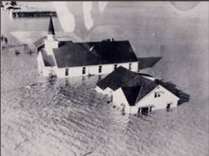
Hazel took direct aim at the heart of Toronto as it roared past at 43 knots (80 km/h). The combined effect of Hazel and the extratropical low that had been in the region resulted in precipitation totals for the period from 7:00 AM Thursday (October 14) to midnight Friday (October 15), of around 210 mm (8.27 inches). Hydrologists from Environment Canada have estimated that 90% of the rain falling on the Humber River basin, the western of two river basins passing through Toronto to Lake Ontario, left as runoff. The Humber basin received the highest rainfall during the storm. On October 16, the Humber River's flow was four times greater than previously recorded. The torrent rushing down the Humber River struck with such force that several bridges were completely shorn from their pilings. When the Humber entered Lake Ontario, the river flow was so strong, that the bodies of several missing persons were eventually found across the lake on the shores of New York State. The raging flood waters destroyed 20 bridges and damaged many others including bridges over the Humber at Bloor Street, Dundas Street, Old Mill, and Albion Road. Where the swollen river met floodplain, it quickly inundated the flat land, sweeping away nearly everything in its path. In the suburb of Weston where the Humber and Etobicoke Creek merged, the waters rose 6 metres (19.7 ft) in an hour when the debris from washed out bridges diverted the river's flow onto the floodplain near Raymore Drive. The wild, rushing waters ripped Raymore Drive houses from their foundations, sweeping away a full block of one- and two-story cottages and the lives of 32 sleeping occupants. Sixty other families were left homeless, and 366 metres (1200 ft) of the street had disappeared. The flooding of a trailer park in Woodbridge by the Black Creek and cottages and trailers in Long Branch by Etobicoke Creek accounted for the losses of 20 and 7 lives, respectively. The five-man pumper crew from the Lambton-Kingsway Fire Department perished when the raging river swept their vehicle away. One body was never recovered. Floodwaters across Toronto killed 81 people and left about 1900 families homeless. Many areas of the watersheds of the now-swollen Don River, Humber River Etobicoke Creek and Mimico Creek had been drained and developed following the war. As a result flood damage was high across the region. Total damage was estimated at $C25 million ($C150 million in 2003 dollars). Major flooding damage from Hazel was not confined to the metropolitan Toronto area. Forty kilometres (25 miles) north of the city lies a tract of once-swampy land that borders the Holland River which flows northward to Lake Simcoe. Now drained and known as Holland Marsh, the 4050 hectare (10,000 acre) tract is rich, productive farmland. The water table is naturally high and the land is kept dry by a system of dikes, but with the intense rainfall from Hazel, the accumulating waters quickly breached the dikes and engulfed the low farmland. Over 3000 residents abandoned their homes to the rising waters. To make matters worse, the yet-to-be harvested vegetables floating in the floodwaters rotted, giving the region a terrible stench, mostly from rotting onions, for weeks following the storm. Hazel, The AftermathWith Hazel's last wild fling over southern Ontario, the storm was almost spent. It continued to race northward, reaching the southeastern shores of Hudson Bay about 24 hours after drenching Toronto. Turning eastward across northern Quebec, the weakening low moved out over the Atlantic and was last recognized as a low pressure cell north of Scandinavia. Hazel's legacy over its eleven-day lifetime from birth near Granada included a deadly punch at Haiti, a swift strike on the United States from the Carolinas north to Lake Ontario, and a deluge of the Toronto region. Hazel tallied between 800 and 1200 deaths, countless injuries, destruction of trees, vegetation and crops, and damage to property conservatively estimated at $461 million ($3.16 billion in 2003 dollars). For its fury run, Hurricane Hazel was "honoured" by having its name retired, the second storm to achieve the distinction, following Hurricane Carol. NOAA's National Hurricane Research Division ranks Hazel the 13th most intense storm ever to strike the United States, following several unnamed storms in the 1900s, Andrew, Camille, and Carla, Donna and Hugo. Learn More From These Relevant Books
|
|||||||||||||||||
 |
To Purchase Notecard, |
Now Available! Order Today! | |
 |
 |
NEW! Now |
The BC Weather Book: |


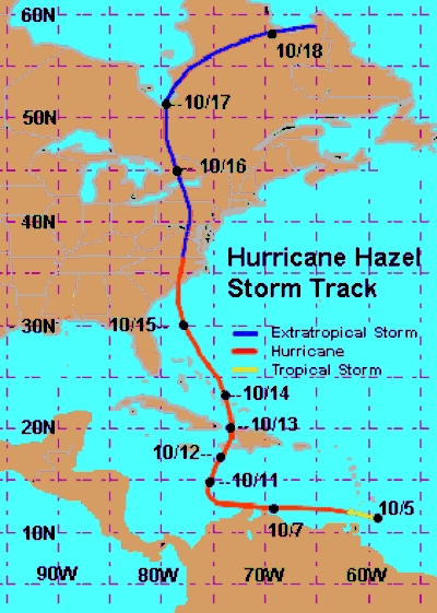 On 5 October, five weeks after Carol lost its hurricane status, a Hurricane Hunter aircraft identified a newly formed tropical storm just east of Grenada in the Windward Islands. It was given the name Hazel. Hazel rapidly gained strength and was declared a hurricane later that day.
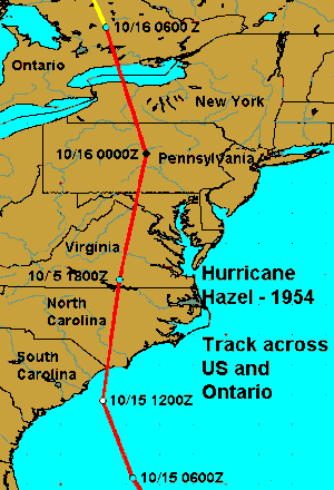 Reported wind speeds, measured and estimated, ranged from 85 to 130 knots (158-241 km/h) along the North Carolina coast, and estimated between 113 to 130 knots (209-241 km/h) from Myrtle Beach SC, to Cape Fear, NC. As the storm moved inland, winds continued to howl, at Raleigh-Durham Airport the winds gusted to 78 knots (145 km/h). Fayetteville NC recorded 96 knots (177 km/h) gusts.