| Home | Welcome | What's New | Site Map | Glossary | Weather Doctor Amazon Store | Book Store | Accolades | Email Us |
 | |||||||||||||||||||
Weather Almanac for April 2000FIRST EYE IN SPACE
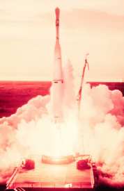
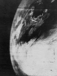
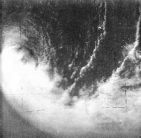
April 1, 1960 was no joke to the global meteorological community. In fact, we can now see it was one of the defining days in the history of weather science when the science began a dramatic leap forward in the understanding of weather on Earth. On this date at 6:40 AM EST, a three- stage Thor-Able rocket system rose from its Cape Canaveral (now Cape Kennedy) launch pad and successfully place a satellite named TIROS I into earth orbit. (TIROS is the acronym for Television and Infra-Red Observation Satellite.) TIROS I began transmitting pictures of clouds and landmarks almost immediately back to earth, the world's first dedicated weather satellite. Anyone under the age of about 45 likely takes for granted the satellite weather information that fills the media today. But when the first picture was released showing the clouds associated with a large storm system, located in southern Canada around the Gulf of St Lawrence and stretching across the northeastern United States, many of us viewed it with fascination and delight. Here for the first time, we could see exactly what weather looked like from that proverbial step-back.
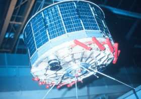
Project TIROS had its birth in May 1958 when the US Committee on Meteorological Satellites began its initial planning sessions. Two months earlier, the President's Science Advisory Committee had reported: "The satellite that will turn its attention downward holds great promise for meteorology and the eventual improvement of weather forecasting." Project TIROS began as a Defense Department project (most early space projects were under the military umbrella) but was transferred to the young, civilian NASA program in April 1959. In October of that year, Wisconsin Senator Wiley, buoyed no doubt by some preliminary clouds photographs from the Explorer satellites, proposed the United States orbit an international weatherman satellite to collect and distribute weather data to the nations of the world. Less than six months later, his proposal became reality. By today's standards, the design of the satellite would be considered crude and the photographs from it coarse, but for the late 1950s, all was state-of-the-art in electronics and video camera design. Weight was still a premium on American launch vehicles and the age of electronic miniaturization was just unfolding driven by the need to fit within size and weight restrictions for space payloads.
TIROS I orbited the Earth every 99.19 minutes at an average height of about 830 km (515 miles). The equatorial orbit ranged from 48 degrees North latitude to 48 degrees South, roughly from Montreal, Canada to Santa Cruz, Argentina; from Le Havre, France to South Africa; from northern Manchuria to New Zealand. At its orbital limits, the satellite could see obliquely to about 55 degrees latitude with the wide-angle lens camera. The two cameras were positioned parallel to the satellite's spin axis and thus looked down on the Earth for roughly only a quarter of its orbit and out toward space or tangent to the Earth for the remaining time. And photographs could only be taken of the sunny side of the planet. The TIROS Project intended its first two satellites to be research satellites only, but as soon as the first pictures were processed and relayed to the US Weather Bureau's National Meteorological Center in Suitland, Maryland, meteorologists saw almost immediately the powerful tool they now had. This caught the project team and Weather Bureau unprepared to handle the volume of information it was receiving from TIROS and to effectively distribute it. Photos came into the Bureau office at a rate of 4000 per week, swamping the scientists charged with analyzing and cataloguing them. Bureau officials quickly asked Congress for an emergency appropriation of $36,000 to handle the classification and index work. Among the first uses of the TIROS I photographs was the conformation of the changing state of the pack ice in the Gulf of St Lawrence and St Lawrence River from April 1-3. Then the satellite's orbit drifted away from the region and the area was not seen again until the ice had melted for the summer. The brief glimpse showed, however, the value of satellite observations in supplementary and eventually replacing aerial reconnaissance.
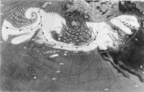
The research experiment was a huge success. US Weather Bureau Chief Francis W. Reichelderfer proclaimed "the spectacular operation of TIROS I had opened a new era in weather surveillance." To which prominent Bureau meteorologists Dr Sigmund Fritz and Dr Harry Wexler added: "TIROS has revealed a large degree of organization in cloud systems over much of the earth's surface. The most striking patterns are the spiral cloud formations associated with large storms, some as much as 1500 miles in diameter...." "It is well known from radar observations that hurricanes are characterized by bands of clouds which spiral inward around a storm center. Although some suggestions have been made that extratropical cyclones also contain bands, over oceans, now as a direct result of TIROS, we see that the spiral-banded cloud structure also exists around well developed extratropical storms..." The initial system had drawbacks for routine weather analysis, however. The nature of TIROS's orbit did not always provide coverage for the day's most interesting or critical weather situation. Forecasters and analysts had to use what they were given rather than what they needed — a far cry from today's full and multifaceted coverage. Only about 20 percent of the earth's surface was visible on any given day and some areas at higher latitudes were never seen. And of course, only daytime pictures were available. Photographs received directly from TIROS were often greatly distorted because of the camera view angles. Early photographs were hand-adjusted before transmission and then re-adjusted by those plotting the weather maps to account for the particular map projection being used. Later, the photographs were adjusted using computer techniques and a composite cloud map or nephanalysis, as they were termed, produced from a series of single images were transmitted by facsimile along data transmission lines to regional weather offices and research centres around the country and the world.
Less than three months after the launch of TIROS I, there was general agreement among the meteorological community that weather satellites could furnish useful information on the distribution of clouds over the earth and provide surveillance of developing storms and storm movement, particularly in data-sparse regions such as the oceans. On November 23, 1960, TIROS II, the second of the ten TIROS satellites was launched. The era of weather satellites as operational observation tools had begun and in the forty years since, scientists have used weather and other earth-viewing satellites to better understand the processes of weather, oceans and life on our planet. On March 29, 1962, Dr Woodrow C. Jacobs opened his report on Meteorological Satellites to the US Senate Committee on Aeronautics and Space Sciences with these words: "The successful launching of TIROS I on April 1, 1960, marked the introduction of an entirely new concept into the thinking of meteorologists throughout the world." The TIROS series would give rise to other meteorological satellite systems over the years such as the Nimbus, ESSA and GOES series. In late 1966, the first geostationary weather satellite ATS-1 would show us our next marvelous view of Planet Earth, a full disk photograph which I would marvel at as much as I had the first TIROS pictures. From the geostationary satellites of the GOES series, cloud motion loops would next reveal to us how weather systems actually moved across the planet. Learn More From These Relevant Books
|
|||||||||||||||||||
 |
To Purchase Notecard, |
Now Available! Order Today! | |
 |
 |
NEW! Now |
The BC Weather Book: |


 The addition of colour and higher resolution cameras would further enhance the beauty of the atmosphere in motion and bring out details my thirteen year-old mind would never have imagined on that day in 1960. Today on the fortieth anniversary of the launch of TIROS I, we take such images for granted. But on April 1, 1960, the first changed forever how we would view the Earth.