| Home | Welcome | What's New | Site Map | Glossary | Weather Doctor Amazon Store | Book Store | Accolades | Email Us |
 | |||||||||||||||||||||||
TIROS I: First Eye in the Sky
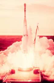
The launch of the world's first weather satellite TIROS I at 0640 EST on April 1, 1960 opened a new era for weather science and humanity's appreciation for the beauty of the global Earth. On 1 April 2010, we mark the 50th anniversary of that monumental launch. Project TIROS, for Television and Infra-Red Observation Satellite, had its birth in May 1958 when the US Committee on Meteorological Satellites began its initial planning sessions. Two months earlier, the President's Science Advisory Committee had reported: "The satellite that will turn its attention downward holds great promise for meteorology and the eventual improvement of weather forecasting." Project TIROS began as a Defense Department initiative (most early space projects were under the military umbrella) but was transferred to the young, civilian NASA program in April 1959.
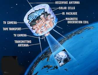
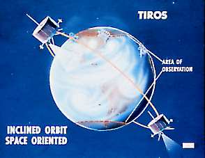
The TIROS I satellite was launched from Cape Canaveral (now Cape Kennedy), Florida on a three-stage Thor-Able rocket system. It achieved a nearly circular, prograde orbit at an angle of 48 degrees to the equatorial plane. TIROS I orbited the Earth every 99.19 minutes at between 796 km (495 statute miles) at perigee and 867 km (539 miles) at apogee. Once stabilized, the orbit gave the satellite coverage of the earth between approximately 48 degrees N latitude and 48 degrees S latitude: roughly from Montreal, Canada to Santa Cruz, Argentina; from Le Havre, France to South Africa; from northern Manchuria to New Zealand. At its orbital limits, the satellite could see obliquely to about 55 degrees latitude with its wide-angle lens camera. TIROS I was a nearly cylindrical, 18-sided satellite, 57 cm (22.5 inches) high, about 107 cm (42 inches) across and weighing 121 kg (267 pounds). It carried two small vidicon tube cameras measuring 7.62 cm (3 inches) long and 3.8 cm (1.5 inches) in diameter, one with a wide-angle lens, the other a low resolution camera. The wide-angle camera covered a surface area 1130 to 1300 kilometres square (700-800 miles square) with a resolution of about 320 m (0.2 miles). The wide- angle lens extended the photographic coverage to around 55 degrees N and S, but the outer limits of the coverage were often at a strongly distorting, oblique angle. A picture scan took approximately 10 to 30 seconds to complete.
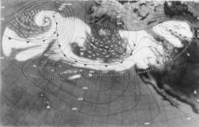
The sides of the satellite were covered with 9620 solar cells which charged the internal nickel- cadmium batteries that ran the cameras, data storage tape recorders, communications equipment and command system. TIROS had three spin-stabilizing rockets, four transmission antennas and one receiving antenna. The satellite was spin-stabilized, spinning on its axis about 12 times per minute. The spin of the satellite acted as a gyroscope to keep the satellite from tumbling randomly through space as it orbited the earth. It also kept the satellite's spin axis pointed toward the same spot in space during each orbit. The two cameras were placed looking out one "end" of the satellite, parallel to its spin axis, both looking the same direction. Because the satellite's spin axis pointed into space, the Earth was only in the camera's view for less than half an orbit. Of that time, only about half of the views were at an angle which gave meaningful pictures, the remaining were too tangential to be of practical use. Thus, only about a quarter of the orbital period provided potentially useful photographs. The spin was oriented so that the cameras pointed toward the Earth on the sunlit side and away from it on the dark side. Therefore, only about 20 percent of the Earth was visible to the cameras on any given day and only when the surface was sunlit. Areas at higher latitudes were invisible to TIROS I. The prograde orbit if TIROS I caused it to drift slowly westward from day to day, causing the orbital plane of the satellite to rotate 360 degrees relative to the stars every 75 days. This and other influences on the orbit slowly brought different latitudes on the photographic perimeter into view and caused others to drop from view until the next cycle repeated. The changing view angle for pictures presented a major problem in perspective and interpretation for eventual users. Rather than a simple circular or rectangular snapshot, the shape of the area of coverage was often wildly distorted. To make the photographs useful to researchers and operational meteorologists (forecasters and analysts), the raw data were rectified into a less distorted view format. Initially, this was done largely by hand and thus was very time consuming. Later, computer programs were used on the data to produce usable pictures and maps.
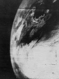
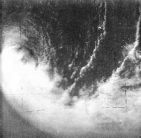
Series of pictures were combined onto a large-scale map to produce a cloud map known as a nephanalysis. These were transmitted via facsimile lines to regional weather offices and research centres around the world. TIROS I and the follow-up TIROS II were intended only to be research satellites, but it was quickly realized that the photographs could furnish useful information on clouds and ice cover and provide surveillance of the development and movement of storms, particularly in data-sparse regions. Among the first uses of the TIROS I photographs was the conformation of the changing state of the pack ice in the Gulf of St Lawrence and St Lawrence River from April 1-3. Then the satellite's orbit drifted away from the region, and the area was not seen again until the ice had melted for the summer. The brief glimpse showed, however, the value of satellite observations in supplementary and eventually replacing aerial reconnaissance.
On June 17, 1960, a failure by the command system to switch off the high resolution camera when it pointed into space led to an excessive drain on the batteries. On June 29, 1960 after 1302 orbits over 78 days, TIROS project managers retired TIROS I. During its lifetime it had generated nearly 23,000 pictures of the Earth and its cloud cover, of which 60 percent had useful information. Indeed, TIROS I generated so many images that they overwhelmed the project organization. Photos came into the Weather Bureau office at a rate of 4000 per week, swamping the scientists charged with analyzing and cataloguing them. Bureau officials quickly asked Congress for an emergency appropriation of $36,000 to handle the classification and index work. The TIROS program continued with the successful launch of TIROS II on November 23, 1960. Eight more TIROS satellites would eventually be launched over the next five years before giving way to more sophisticated satellite systems. TIROS VII and TIROS IX remained operational until 1974. Learn More From These Relevant Books
|
|||||||||||||||||||||||
 |
To Purchase Notecard, |
Now Available! Order Today! | |
 |
 |
NEW! Now |
The BC Weather Book: |