When you hear the word thunderstorm
in the daily weather forecast, you automatically think of thunder and
lightning accompanied by rain, often as a drenching cloudburst, and
wind, gusty at times. Not all thunderstorms are wet, however,
particularly in western North America from the Mexico-Arizona border
north into British Columbia and the Canadian Prairies. And that worries
those watching for or fighting wildfires. These thunderstorms are
called dry thunderstorms.
When I say that no rain
is falling from the thunderstorm, what I really mean is that no rain
falling from the thunderstorm reaches the earth's surfaces. Through
most of the life of any thunderstorm, rain falls within the
thundercloud and often descends below the cloud base. But in a dry
thunderstorm, the rain never wets the ground below, even if we can see
it exit the cloud. What has happened to that moisture?
Simply
put, it evaporated on its descent to the surface. We can see evidence
of this if we look under the towering cloud and see streaks or wispy
areas below the base that never reach the ground, a condition know as virga.
How far below the cloud the virga extends depends on two main factors:
the dryness of the air below cloud base and the size of the raindrops.
Small drops falling through dry air disappear quickly through
evaporation. Even hail can melt and evaporate before reaching the
surface, and larger drops can evaporate if the air is dry enough.
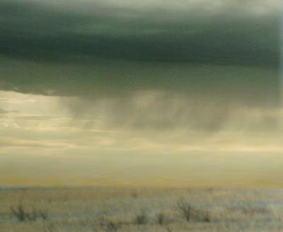
Virga from dry thunderstorm over the prairies. Photo Courtesy NOAA, US Dept of Commerce
Dry
thunderstorms are more frequent in the western regions of the continent
where the air near the surface is often desert-dry and the cumulonimbus
cloud base is high in altitude. That region is also the most
susceptible to grass and forest fire dangers.
Although dry
thunderstorms produce no surface rain, they do produce cloud-to-ground
lightning and gusty, erratic winds. And this is what wildfire watchers
and fighters fear, for lightning hitting trees can spark a blaze at
anytime, but often the rain extinguishes it before it burns out of
control. But lightning from a dry thunderstorm will not only set timber
ablaze, it can often fan the flames with the associated winds.
Large
fires may even generate their own thunderstorms, and these are
frequently dry. The clouds associated with fire-generated thunderstorms
are termed pyrocumulonimbus clouds (pyro meaning
"fire"). Here is how they form. The heat generated by the fire,
combined with moisture driven from the forest and soil and evaporated
from any standing water bodies, can initiate the formation of cumulus
clouds above the fire zone. When proper atmospheric conditions surround
these clouds, some may erupt into pyro-thunderstorms
(fire-generated). Often, any rainfall from a pyro-thunderstorm is
quickly evaporated in the dry air above the fire zone and thus never
reaches the ground.
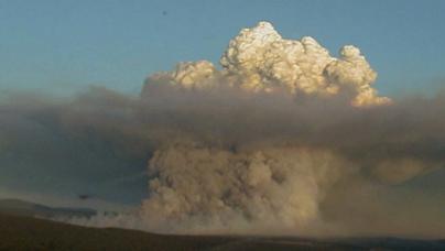
Pyrocumulus Cloud. Courtesy: US National Interagency Fire Center
When such storms arise rapidly, firefighters term it a blow up,
a very dangerous situation to firefighters and property owners alike.
Pyro-thunderstorms can drastically change conditions facing
firefighters, including the ignition of additional fires from its
lightning. Thus, pyro-thunderstorms are feared because of the rapid
changes they can make to the nature of the fire and the direction of
the fire's movement. Inflow and outflow winds associated with the
storms add oxygen to the mix and can suddenly push the flames in a
different direction causing them to jump ahead as burning embers are
carried to regions not currently burning. Such conditions can trap
firefighters and is a prime cause of death and injury among the
firefighters. (For more on fire weather, see my article Fire Weather.)
Away
from dry forests in agricultural lands, dry thunderstorms popping up
during drought or dry times are a tease to farmers and others dependent
on rains. Many a hope of rain has been raised by distant flashes and
rumbles, but in passing, only the sound and the fury arrive and none of
the expected rainfall.
Learn More From These Relevant Books Chosen by The Weather Doctor
Williams, Jack: The Weather Book, 1997, Vintage Books, ISBN 0-679-77665-6.
For More Weather Doctor articles, go to our Site Map.
I have recently added many of my lifetime collection of photographs and art works to an on-line shop where you can purchase notecards, posters, and greeting cards, etc. of my best images.