| Home | Welcome | What's New | Site Map | Glossary | Weather Doctor Amazon Store | Book Store | Accolades | Email Us |
 | |||||||||
The DerechoSolar summer— that quarter of the year when solar heating reaches its maximum potential in the Northern Hemisphere — begins on May Day, and thereafter, April's showers become bold thunderstorms. We associate many storm elements with severe thunderstorms. Lighting and thunder, gusty winds, hail, flash floods, and tornados are the most well-known features, but we cannot forget downbursts — and their little brothers, the microbursts — gustnadoes, heatbursts and derechos. The derecho (pronounced Deh-RAY-cho) is a violent, widespread windstorm emanating from long-lived thunderstorm complexes. Derechos produce damaging, straight-line winds of 100 to 160 km/h (60 to 100 mph) that are strong enough to down trees and power lines. They rush across a region along paths tens of kilometres (miles) wide and hundreds of kilometres (miles) long. Derecho damage is continuous and non-random over a large area. Gustavus Hinrichs coined the term in the 1880s when he served as Director of the Iowa Weather Service. Derechos are straight-line winds in contrast to the circular winds of tornadoes. For this reason, Hinrichs named them from a Spanish word meaning "straight ahead" as a contrast to "tornado," which derives from the Spanish for "turning." To be classified as a derecho, the storm must produce winds in excess of 93 km/h (58 mph) over a path at least 450 km (280 miles) long. When a derecho strikes, its damaging winds, often gusting to 250 km/h (155 mph), may blow for several hours. Thus, the dangers associated with derechos arise from both the strength and duration of the wind. Derecho widths vary from 80-480 km (50-300 miles), thus, they are also large spatial events, affecting areas as great as 2000 km2 (780 mi2), rivalling the area covered by a hurricane. Much of our current understanding of the nature of derechos and their formation has only been gained in the past couple of decades. Recent advances in weather science and technology, such as doppler radar and detailed satellite imagery, have enabled meteorologists to peer into the core of severe storms and unravel many of their secrets.
Derechos arise from extratropical MCSs when squall-line thunderstorms create a sustained series of downbursts as they advance. These cold downbursts blast outward from the squall line striking, then hugging, the surface as the storm advances. Derechos most commonly form along nearly stationary fronts lying approximately west-east that separate very warm, moist, and unstable air on the south from a relatively cool, dry air to the north. The derecho typically moves eastward along the front, veering toward the warm air mass to the south (or right). Severe-storm researchers distinguished between two types of derechos, progressive and serial, which differ in their formation process and peak season of occurrence. Progressive derechos generally emerge in the spring and summer spawned by the abundant solar energy that heats the surface and the lower atmosphere. These are the most common type, accounting for about three quarters of all derechos. Progressive derechos do not depend on strong synoptic or dynamic forcing of convection. Almost all progressive derechos form on the cool side of a semi-stationary front. They often manifest as bow echoes on weather radars, forming a bulge in the center of a squall line. Typically, conditions found ahead of the bow-echo arch include high winds, small hail, and the chance of weak tornadoes. When the bow echo bulge reaches 80-320 km (50-200 miles) wide, the derecho has been born. Once formed they can race across the landscape at 65 km/h (40 mph) and are self-sustaining. 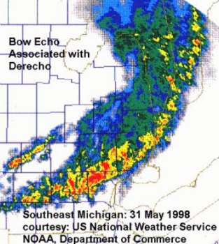 Radar image of derecho moving through southeast lower Michigan 31 May 1998 |
|||||||||
 |
To Purchase Notecard, |
Now Available! Order Today! | |
 |
 |
NEW! Now Available in the US! |
The BC Weather Book: |


 Derechos are members of a group of weather phenomena known as mesoscale-convective systems (MCSs) —
large, organized weather systems comprised of a number of individual thunderstorms. MCSs evolve from
isolated thunderstorm cells or from a small cluster of thunderstorm cells, but at times, they simply burst forth
fully formed from the outset. MCSs typically arise in the late afternoon or evening, lasting from two to
twenty hours. They are associated with regions of very heavy rains and often spawn squall lines, bow echos
and derechos. MCSs are most common in the Plains, Midwest and Ohio Valley States. About 80 percent of
all derecho events spawn tornadoes; however, less than half produce more than two tornadoes over their
lifespan.
Derechos are members of a group of weather phenomena known as mesoscale-convective systems (MCSs) —
large, organized weather systems comprised of a number of individual thunderstorms. MCSs evolve from
isolated thunderstorm cells or from a small cluster of thunderstorm cells, but at times, they simply burst forth
fully formed from the outset. MCSs typically arise in the late afternoon or evening, lasting from two to
twenty hours. They are associated with regions of very heavy rains and often spawn squall lines, bow echos
and derechos. MCSs are most common in the Plains, Midwest and Ohio Valley States. About 80 percent of
all derecho events spawn tornadoes; however, less than half produce more than two tornadoes over their
lifespan.