| Home | Welcome | What's New | Site Map | Glossary | Weather Doctor Amazon Store | Book Store | Accolades | Email Us |
 | |||||||||
Microbursts and HeatburstsLast month, I introduced a large-scale thunderstorm phenomenon known as the derecho. This month, I will look at two very localized thunderstorm events: the microburst and the heretofore rare heatburst. You likely have heard of microbursts, strong, damaging winds which strike the ground and often giving the impression a tornado has struck. They frequently occur during intense thunderstorms and have been linked to several aviation disasters. Heatbursts, on the other hand, are more rare and likely will only make the news as a weather oddity due to the sudden rise in temperature that mark their occurrence. Both, however, have similar origins, downward moving air from a thunderstorm's core, and affect only a rather small area. Microbursts
A downburst, Fujita explained, was a straight-direction surface wind in excess of 62 km/hr (39 mph) caused by a small-scale, strong downdraft from the base of convective thundershowers and thunderstorms. Later investigations into the phenomena led him in 1981 to define two sub-categories of downbursts: the larger macrobursts and small microbursts.
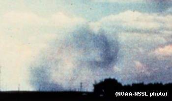
Downbursts of all sizes descend from the upper regions of severe thunderstorms when the air accelerates downward through either exceptionally strong evaporative cooling (a dry downburst) or by very heavy rain which drags dry air down with it (a wet downburst). When the rapidly descending air strikes the ground, it spreads outward in all directions, like a fast-running faucet stream hitting the sink bottom.  When the microburst wind hits an object on the ground such as a house, garage or tree, it can flatten the buildings and strip limbs and branches from the tree. After striking the ground, the powerful outward running gust can wreak further havoc along its path. Damage associated with a microburst is often mistaken for the work of a tornado, particularly directly under the microburst. However, damage patterns away from the impact area are characteristic of straight-line winds rather than the twisted pattern of tornado damage.  Microbursts are a particular threat to aircraft because they can force the aircraft rapidly to the ground or push either the tail or nose of the aircraft downward, causing the pilot to loose control, but in the past were generally undetectable because of their small size. Today, doppler radar allows a better fine-scale coverage of wind fields around airports. Microbursts are not only hazardous to aircraft, they can also overturn boats on lakes, or quickly fan a forest fire into a raging inferno. HeatburstsAnother "burst" that may drop from a thunderstorm is the heatburst. If you have experienced thunderstorms, then you are likely quite familiar with the cold wind gusts flowing from the thundercloud that frequently bring welcome relief from oppressive summer heat. Most thunderstorms produce these cool gusts of wind, but occasionally, a very hot, blast of air descends instead, an event known as a heatburst. Meteorologists are still unclear on the exact mechanism behind the heatburst. However, storm researchers believe they originate in the highest levels of tall thunderstorm clouds and are similar in nature to the dry microburst. Here is the suspected scenario for the occurrence of the majority of heatbursts. As the sun sinks in the evening sky, its heating of the ground surface first diminishes, then ceases altogether. Without the solar heating to lift them, the warm, moist, rising columns of air that fuel the thunderstorm cell terminate, thus shutting off the storm's main core updraft. Without the updraft, raindrops in the storm's upper levels can no longer be held aloft, and the storm begins to collapse. The raindrops drop into the cool, dry air entering the storm from its rear where they evaporate, further cooling the air. This mass of cold air is now very heavy relative to the air around it and plunges rapidly earthward. Usually, this sequence of events produces an outburst of cold air from the storm. However, should the plunging air drop from a very high altitude, say over 6100 metres (20,000 feet), it warms significantly by compression (like the air inside a bicycle pump) during the descent. Such compressional warming makes the air lighter — more buoyant — which should arrest its descent, but in this instance, the downdraft's momentum is too great to be halted, and the air slams into the surface, spreading outward as a hot, dry gust of wind. Any tall, dying storm can produce a heatburst if sufficient evaporation takes place high in the cloud, so heatbursts can also form late at night and in the early morning. A heatburst's intensity depends on the initial size of the collapsing storm and the degree of warming before the air hits the ground. Heatbursts are considered unusual events, but no one really knows how frequently they may actually occur. Many likely strike in the vast, open lands of mid-continent from Texas to the Canadian Prairies but are never detected due to the scattered population and lack of weather instruments in the region to observe them. When they are experienced, the surface temperature rise can be dramatic. One heatburst, caught in the Oklahoma Mesonet weather-observing network on May 22, 1996, spiked the temperature from 31 to 39 oC (88 to 102 oF) over 25 minutes. As the temperature rose, wind gusts reached 170 km/h (105 mph) within the ten-county coverage area. Several other, smaller heatbursts have been caught by the Mesonet over the past three years. Another heatburst was caught by instruments in the San Angelo, Texas area shortly after midnight on 14 August 2002. The following is extracted from the US National Weather Service report on the incident: The heatburst developed when a decaying thunderstorm complex slowly dissipated over the region....The temperature observed at 12:35 AM on the 14th was 75 degrees F [23.9 oC], with a south wind at 31 mph [50 km/h] gusting to 40 [64 km/h] with a relative humidity of 62 percent. The observation at 1:05 AM reported the temperature jumped to 94 degrees F [34.4 oC], winds northwest at 15 [24 km/h] gusts to 40 [64 km/h] with a relative humidity of 19%. The event ended by 1:30 AM, the temperature fell back to 73 degrees F [22.8 oC], winds south at 31 mph [50 km/h], relative humidity at 66 percent. The phenomenon is not just for the American continent. A reported heatburst occurred in Melilla, Spain on 23 July 2001 beginning at 8:24 AM. In this event, the temperature jumped from 24 to 41 oC (75 to 106 oF) in five minutes. The wind during the heatburst gusted to 70 km/h. A second burst occurred around ninety minutes later with temperature rising 15 C degrees (27 F degrees) in a short period. Microburst photograph, courtesy NOAA Photo Library, NOAA Central Library; OAR/ERL/National Severe Storms Laboratory (NSSL). Learn More From These Relevant Books
|
|||||||||
 |
To Purchase Notecard, |
Now Available! Order Today! | |
 |
 |
NEW! Now Available in the US! |
The BC Weather Book: |


 Famed University of Chicago storm researcher Dr Ted Fujita (who also developed the Fujita Tornado
Damage Scale) first coined the term downburst to describe strong, downdraft winds flowing out of a
thunderstorm cell that he believed were responsible for the crash of Eastern Airlines Flight 66 accident at
John F. Kennedy Airport in New York on June 24, 1975.
Famed University of Chicago storm researcher Dr Ted Fujita (who also developed the Fujita Tornado
Damage Scale) first coined the term downburst to describe strong, downdraft winds flowing out of a
thunderstorm cell that he believed were responsible for the crash of Eastern Airlines Flight 66 accident at
John F. Kennedy Airport in New York on June 24, 1975.  Macrobursts are downbursts with winds up to 188 km/h (117 mph) which spread across a path greater than 4
km (2.5 miles) wide at the surface and which last from 5 to 30 minutes (a situation still much smaller and
shorter than the derecho). The microburst, on the other hand is confined to an even smaller area, less than 4
km (2.5 miles) in diameter from the initial point of downdraft impact. An intense microburst can result in
damaging winds near 270 km/hr (170 mph) and often last for less than five minutes.
Macrobursts are downbursts with winds up to 188 km/h (117 mph) which spread across a path greater than 4
km (2.5 miles) wide at the surface and which last from 5 to 30 minutes (a situation still much smaller and
shorter than the derecho). The microburst, on the other hand is confined to an even smaller area, less than 4
km (2.5 miles) in diameter from the initial point of downdraft impact. An intense microburst can result in
damaging winds near 270 km/hr (170 mph) and often last for less than five minutes.