| Home | Welcome | What's New | Site Map | Glossary | Weather Doctor Amazon Store | Book Store | Accolades | Email Us |
 | |||||||||||||||||||
The Arctic Mirage:
|
|||||||||||||||||||
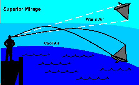 |
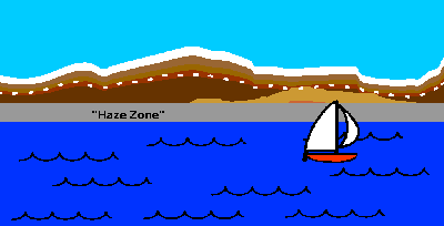
The arctic or superior mirage is quite the opposite phenomenon from the desert or inferior mirage, which is familiar to all highway travelers as an apparent pool of water lying on the roadway disappearing as it is approached. Under conditions favorable for viewing a desert mirage, the light rays from the sky are bent upward in a curve away from the surface by hot, light air near the ground and to the eye of the observer. The arctic mirage, on the other hand, occurs when the light rays are refracted downward by cold, dense air near the earth into an arc bending toward the observer. (In the diagrams accompanying this article, the dark lines indicate the actual light ray path and the white dashed lines the path our mind thinks it sees.)
The refractivity of air -- a measure of the air's ability to bend the path of light rays -- is dependent upon its density, and the density of air is inversely related to its temperature (decreasing as temperature increases). The atmospheric conditions for producing the arctic mirage occur when cool air adjacent to the surface underlies warm air. When the air temperature increases with altitude, the condition is known meteorologically as a temperature inversion.
When the temperature of the lower atmosphere increases with altitude at a rate of 11.2 C° per 100 metres (6.0 F° per 100 ft), the refractive capacity of the air is great enough to cause the path of light rays to bend in an arc equal to the curvature of the Earth. This curvature can present an observer with the image of a flat horizon receding to infinity. A temperature gradient greater than 11.2 C° per 100 m causes light ray paths to exceed the curvature of the Earth, and thus the horizon would appear to be raised upward giving the Earth's surface a saucer-shaped appearance. Under this latter condition, images of objects located at or below the normal optical horizon, such as mountains, glaciers, cliffs or sea-ice rise (loom) into the field of vision, overcoming the normal visual restrictions of the curvature of the Earth.
The normal viewing distance at the surface of the earth depends upon the height of the object being observed and the height of the observer. Disregarding atmospheric effects on light rays, the curvature of the earth restricts the distance one can see from the surface. For example, a beach or small iceberg rising 3.0 to 3.7 m (10 to 12 ft) above the sea surface can be seen from the surface at a distance of no more than 19.2 km (12 miles) through a clear, normal atmosphere. A mountain peak of 914 metres (3,000 feet) would disappear at 115 kilometres (72 miles) distant, one 1520 m (5,000 ft) tall at 150 km (94 miles).
The maximum viewing distance under arctic mirage conditions, on the other hand, is limited only by the light absorption of the atmosphere. Near sea level, the transmission of light is generally of sufficient quality to enable the naked eye to potentially see objects at a distance of up to 400 km (250 miles). However, when the refracting layer is at the upper boundary of a very deep cold layer, the thinner air may permit more light to be transmitted, thus making visibility in excess of 400 km possible.
 |
| The Arctic Mirage allows seeing objects over the horizon. Scale is greatly exaggerated. |
Under arctic mirage conditions, instances of atmospheric visibility extending 320 km (200 miles) have been reported. In 1937 and 1939, W.H. Hobbs documented several occasions during which objects were sighted at distances well in excess of those possible under normal viewing conditions. One significant arctic-mirage sighting occurred on May 24, 1909 when Commander Donald B. MacMillan observed and clearly recognized Capes Joseph Henry and Hekla in Grant Land from his position on Cape Washington on the north Greenland coast 320 km (200 miles) away.
Captain Robert A. Bartlett, master of the Effie M. Morrissey, reported one of the most extraordinary accounts of extended visibility under arctic mirage conditions on July 17, 1939. His ship was positioned midway between the tip of south Greenland and Iceland. The air was calm and the sea smooth when, at 4 PM, with the sun to the southwest, a mirage appeared in the direction of southwest Iceland. Among the known landmarks sighted by the captain and the mate was the 1,438 m (4,715 ft) high Snaefells Jökull glacier. Captain Bartlett remarked that during his forty years sailing in the Arctic, he had seen many arctic mirages but none so singular as this one nor one so well-checked for position and distance.
Bartlett wrote: "If I hadn't been sure of my position and had been bound for Reykjavik, I would have expected to arrive within a few hours. The contours of the land and the snow-covered summit of the Snaefells Jökull showed up unbelievably near." The apparent distance of those landmarks was judged to be 40 to 50 km (25 or 30 miles) distant; however, from ship's actual recorded position, they were located 536 to 560 km (335 to 350 miles) away! Without the influence of the arctic mirage, the Snaefells Jökull should not have been visible beyond 150 km (94 miles).
The arctic mirage can thus cause polar explorers to underestimate the distance of landmarks in new lands, and these distances may be miscalculated by as much as three to five hundred kilometres (two to three hundred miles). Professor Hobbs noted several such errors in various expedition records and attributed the mislocation of landmarks to the influence of the arctic mirage. Indeed, several explorers claimed to "discover" large surface features that we now know do not exist. What they were likely seeing were minor surface features enhanced by superior mirage conditions, either the arctic mirage variety or the Fata Morgana effect, to look like mountains.
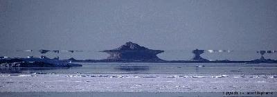 |
©1999, Jack Stephens Images, All Rights Reserved. Used with permission. |
For example, in 1818, Sir John Ross observed and named the "Crocker Mountains" in the Canadian Arctic, which he estimated to be 50 km (30 miles) away from his position in Lancaster Sound and appeared to block his way to finding the Northwest Passage. No such physical landmark has ever been found to exist. Hobbs hypothesized that Ross had actually seen the snow capped heights of North Somerset Island looming up from their actual position 320 km (200 miles) distant.
Interestingly, in 1913 the aforementioned Captain MacMillan lead an expedition to locate Crocker Land and the Crocker Mountains. As the expedition approached Ross' coordinates for the mountains, MacMillan wrote: "There can be no doubt about it. Great heavens, what a land! Hills, valleys, snow-capped peaks extending through at least 120 degrees of the horizon." They pushed forward across the arctic ice for 50 km (30 miles) inland and found...NOTHING! Crocker Land and the Crocker Mountains had been mirages!
Did Ross and MacMillan both actually see the distant heights of North Somerset Island? Or did they see a display of the Fata Morgana which they interpreted as mountain peaks?
Similarly, in 1841 Captain Sir James Clark Ross viewed, from east of Ross Island off Antarctica, mountains he named the "Parry Mountains" that appeared to be about 40 km (25 miles) distant No actual mountains exist at that position; however Hobbs believes that Ross may actually have seen, under arctic mirage conditions, the distant high range that includes Mt Albert Markham and Mt Hamilton, which are nearly 500 km (300 miles) further along the same sight line.
The strong effects of the arctic mirage on what the peoples of the Arctic regions have seen around them has had profound influences on the oral legends and histories of the native communities. H.L. Sawatzky and W.H. Lehn studied the legends and sagas of the Celts and Vikings, as well as Greek and Roman mythologies and commentaries, and theorized that the arctic mirage contributed greatly to the early European view of the northern world regions and influenced the early exploration of the north Atlantic and Arctic Oceans.
In ancient European accounts, the belief was widely expressed that the world was either flat or saucer shaped, having a definite rim beyond which lay the dreaded abyss. Could arctic mirage conditions have influenced this belief that the Earth's surface was flat or saucer shaped?
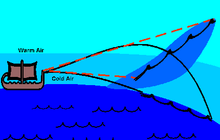 |
| Superior Mirage can give the impression the horizon tilts upward, giving a saucer shape. Scale is greatly exaggerated. |
As we have seen, under certain, rather common weather conditions, the bending of light rays can give the impression that the Earth's surface is flat or turned up rather than its true rounded downslope. But can that illusion be strong enough to influence the world view of whole populations?
There are many convincing accounts of this illusion from polar explorers searching for the Northwest Passage and trekking to the Pole. But we also have this fascinating account from the Canadian west. David Thompson explored the region during the period 1784-1812. In his Narrative of His Explorations in Western Canada, he presents this striking account of the saucer illusion:
"What is called Mirage is common on all these Lakes but frequently [sic] simply an elevation of the woods and shores that bound the horizon....While the mirage is in full action, the scenery is so clear and vivid, the illusion so strong as to perplex the Hunter and Traveller; it appears more like the power of magic than the play of Nature.... On one occasion...the ice between me and the Isle appeared of a concave form, which, if I entered, I would slide into its hollow, sensible of the illusion, it had the power to perplex me. I...advanced slowly, as if afraid to slide into it...."
Without terrestrial landmarks for orientation, the impact of a saucer-like horizon cause by an arctic mirage would be more profound at sea, and could account for some early concepts of the shape of the Earth. The Vikings, for example, believed there lay a land in the far north called Ultima Thule. In this land at the edge of the world, they believed, all the ocean waters flowed back into the earth to regenerate through underground channels all the world's rivers and streams. Such a funneling of waters suggests an upturned landscape for the waters to run off of. Indeed, it is believed that the word Thule is of Celtic origin and means "to raise" or "to raise oneself." A reference to an arctic mirage upturn of the horizon? Viking mariners also believed in massive and deadly whirlpools and sea walls associated with the approach to Ultima Thule. Were these oral legends also the result of an arctic mirage influence?
Although the arctic mirage provided an image of the northern oceans that discouraged the exploration of unfamiliar waters, it may also have furnished the primary incentive for ancient mariners to investigate those waters and to discover new territories. The Vatna glacier in Iceland rises 2000 metres (6,557 ft) above the sea. Its distance to the Faeroe Islands of the Celts is 385 km (240 miles) to the southeast. Given the reports from modern mariners such as Captain Bartlett, it is very possible the Celts could sight the glacier from the Faeroes under atmospheric conditions conducive to the arctic mirage. And in these regions, the season when storms are least frequent -- the summer -- is most conducive to the formation of arctic mirages and to sailing currachs away from the protection of the coast.
Once veteran seafarers realized that certain weather conditions could aid in their travels, the arctic mirage probably served as a navigational aid as well. Remember, these were the days before compasses and knowledge of latitude/longitude grid systems. The Vikings were known masters of using landmarks for marine navigation as they left the protected Norwegian fjords and raided distant lands to the south.
 |
Perhaps the best illustration comes from the initial migration of the Norse from Iceland to Greenland. In 874 the Norse Vikings settled in Iceland, probably discovering the island using knowledge of its location obtained from the recently conquered Celts. A century later, a former Norse chieftain Erik the Red was banished from Iceland following a feud that had resulted in manslaughter. Erik was well aware of the Viking sagas that told of voyages to a land in the northwest ocean and the persistent legends of something neither water nor sea ice beyond the northwestern horizon. So, when Erik and his entourage set sail around 982 from the northeast corner of Iceland in search for a place to live, they headed almost directly northwest. In this direction, a voyage covering 300 km (186 miles), would be the shortest distance between Iceland's northwest coast and Greenland. To reach Greenland on this course, however, his ships would face contrary winds and currents only to arrive at a coastline protected by sea ice. Once reaching the coast, they then would have to turn southward and travel several hundred hard kilometres before they would eventually reach the fjord country of southern Greenland, where the Eastern and Western Settlements were ultimately established.
If Erik had piloted his ships southwestward initially, following the push of known favorable winds and currents, he would have easily reached the south coast of Greenland. What, then, persuaded him to select the northwest route? Under normal atmospheric conditions, the coast of Greenland is not visible from Iceland, even taking into account their highest coastal elevations. But under arctic mirage conditions, mountains on the Greenland coast can become visible from the cliffs of Iceland. Erik probably gleaned such navigational information via the sagas and discussions with other mariners, and thus knowing that a land existed along that heading, steered directly for the landmark.
Voyages from Greenland by the Vikings to the coast of North America where they established the Vineland Colony were likely further aided by the arctic mirage. From the 2,226-m (7,300-ft) peak of Hrafnsgnipa on the western Greenland coast to the 2166-m (7,100-ft) coastal mountains of Cape Dyer on Baffin Island in the Canadian Arctic is 440 km (274 miles). Viewed from the Hrafnsgnipa peaks, the Cape Dyer heights are only slightly out of normal visual range. The distance required for a sighting between a 2,226-m elevation and a 2166-m peak, as determined by normal curvature restrictions, is 411 km (257 miles). Thus, an arctic mirage need only improve viewing distance by ten to fifteen percent to allow a sighting. Such an improvement in sighting distance would not require more than an average mirage condition. And if the mirage effect was strong could have given the impression that these lands were much closer.
Once the connection between Greenland and the Canadian Arctic islands had been made, the link between Europe and North America was completed. The discovery of North America and eventual colonization by a Viking band lead by Erik's son Lief, now a millennium past, would follow quickly.
For details on mirages, their causes and properties, see
Mirages in the Weather Phenomenon and Elements Section.
The Inferior Mirage: Not Just For Deserts Anymore in the Weather Elements and Phenomena Section,
The Superior Mirage: Seeing Beyond in the Weather Elements and Phenomena Section,
and
Did Those Mountains Grow Overnight? in the Weather Almanac Section.
 |
To Purchase Notecard, |
Now Available! Order Today! | |
 |
 |
NEW! Now |
The BC Weather Book: |


