| Home | Welcome | What's New | Site Map | Glossary | Weather Doctor Amazon Store | Book Store | Accolades | Email Us |
 | |||||||||||||||||||||||||||||||||||||||||||||||||||||||||||||||||||||||||||||||||||||||||||||||||||||||||||||||||||||||||||||||||||||
Dreaming of A White Christmas?When Bing Crosby crooned "I'm dreaming of a white Christmas", in the movie Holiday Inn in 1942 and later that year on a massive hit record, I am sure he had no idea that he was changing the way North Americans, as well as folks around the world, looked at the holiday season. As a result, I think the most asked question of meteorologists — at least during the later months of the year — is: "Are we going to have a white Christmas?" Well...., perhaps the second most asked most behind: "Will it rain/snow?" In Irving Berlin's first version of the song White Christmas, he had the singer be a Southern Californian nostalgic for the cold crisp snowy Christmas season back in his native New England. The opening verse was later dropped. But there are many Americans and quite a few Canadians who would share with his sentiments, even if a New England Christmas as depicted by Currier and Ives was not exactly their dream. These folks know full well that the deck is stacked against them for seeing a white Christmas live.
There are many possible ways to define a white Christmas including:
In Canada, senior climatologist at Environment Canada David Phillips used for his definition in the probability calculation: A white Christmas has at least 2 cm of snow on the ground on December 25th. The American definition is close, but because they still use Imperial units, their definition in the analysis is: A white Christmas has a snow depth of at least 1 inch on the ground at 7 AM on December 25th. I am not sure why Phillips picked 2 cm rather than 2.5 cm which would have been close to the 1 inch equivalent (1 inch = 2.54 cm), but the whole concept is arbitrary anyway. In neither case could one go cross-country skiing easily over the river and through the woods with that little snow, and I would imagine a sleigh would have tough going in only 1 inch or 2 cm of snow. As we shall see, other definitions are defined as well in the specific national analyses. A Canadian White ChristmasThe analysis of likelihood of a white Christmas for Canada is provided courtesy of my friend Dave Phillips who supplies us all with great weather trivia all year long. (I love his Weather Trivia Calendar and look forward to his top Canadian Weather Stories which come out yearly.) Dave compiled 45 years of weather data for cities all across Canada to determine the probability for a white Christmas. He also added a special definition for a perfect Christmas: A perfect Christmas requires a light snow fall during Christmas day with at least 1 cm further accumulation and at least 2 cm of snow on the ground as the day begins. I will only look at the likelihood of a white Christmas in this piece, but Dave has filled our Christmas weather stocking with much more, including the greatest Christmas Day snowfalls. For his full analysis, visit the Environment Canada site. From his analyses, he presents the map given below: 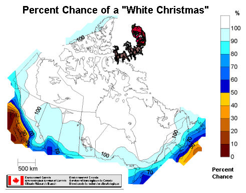 Here is a brief table of the probabilities for major Canadian cities. For a more complete list, go to the Environment Canada probability chart.
For those that think Canada is always cold and snowy, the chart shows that for many major population centres, the odds of a white Christmas are less than 50/50, especially for residents of Greater Vancouver and Victoria (20 percent chance). I lived in Victoria for 14 Christmases and none were white that I recall. This is ironic because we had a record 124 cm (48.8 inches) of snow fall between December 21 and 29, 1996 and yet Christmas Day was green in the city! Coastal Nova Scotia does not fair much better, being white only about 40 percent of the time. For much of the northern tier of Canada, however, the odds are a near certainty for a white Christmas. Four major cities had a perfect record of white Christmases over the last 30 years in the study record: Quebec City, Quebec; Thunder Bay, Ontario; Yellowknife, Northwest Territories and Iqaluit, Nunavut. The North Pole, as represented by Alert is a sure bet, though a long shot for a perfect Christmas at 9 percent according to Phillips. Alert shares a low probability of a perfect Christmas with Windsor, Ontario; Calgary, Alberta; and Victoria and Vancouver, British Columbia. Sault Ste Marie, Ontario is the place to be for a perfect Christmas since it receives a fair amount of lake-effect snowfalls. The greatest Christmas Day snowfall in Canadian meteorological records in a major city accumulated 32.8 cm (12.9 inches) in Montreal in 1966. A US White ChristmasThe report on the probability of a white Christmas in the United States was written by meteorologists Neal Lott, Tom Ross, and Matthew Sittel with the National Climatic Data Center (NCDC). The database used in the study was the previous climate normals period 1961-1990. (I can find no similar analysis using the latest normals.) The analysis from the National Climate Atlas of the statistical probability (in percent) of at least one inch of snow on the ground on Christmas Day can be visualized in the map given below for the contiguous states. (Probabilities are high for most of Alaska and nil for Hawaii, except at the higher elevations of Mauna Loa. 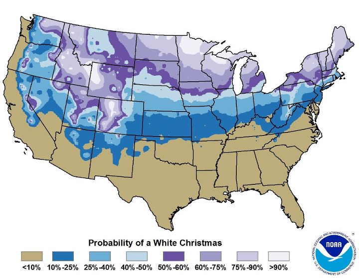 Probability (in percent) of a snow depth of at least one-inch on the morning of December 25th, based on the 1971-2010 climate normals |
|||||||||||||||||||||||||||||||||||||||||||||||||||||||||||||||||||||||||||||||||||||||||||||||||||||||||||||||||||||||||||||||||||||
Probabilities for a White Christmas(Probabilities based on 1961-1990 Normals | |||
| City | Probability | City | Probability |
| ANCHORAGE AL | 90 | FLAGSTAFF AZ | 56 |
| DENVER CO | 50 | WASHINGTON DC | 13 |
| CHICAGO IL | 40 | TOPEKA KS | 23 |
| PORTLAND ME | 83 | BOSTON MA | 23 |
| DETROIT MI | 50 | MINNEAPOLIS MN | 73 |
| ST LOUIS MO | 23 | HELENA MT | 67 |
| OMAHA NE | 44 | CONCORD NH | 87 |
| ATLANTIC CITY NJ | 7 | BUFFALO NY | 57 |
| NEW YORK NY | 10 | FARGO ND | 83 |
| CINCINNATI OH | 11 | CLEVELAND OH | 50 |
| PORTLAND OR | 0 | PHILADELPHIA PA | 10 |
| PITTSBURGH PA | 33 | PROVIDENCE RI | 37 |
| RAPID CITY SD | 47 | NASHVILLE TN | 13 |
| SALT LAKE CITY UT | 53 | BURLINGTON VT | 77 |
| RICHMOND VA | 7 | SEATTLE WA | 7 |
| SPOKANE WA | 70 | ELKINS WV | 35 |
| MILWAUKEE WI | 60 | CASPER WY | 47 |
For a more extensive list, you can go to the NOAA publication from which these analyses were taken: "Will We Have a White Christmas?" The analyses in this report give probabilities for two other Christmas Day scenarios: At least five inches of snow on the ground and at least ten inches.
A second analyses looking at the full period of record for a given station (rather than just the 1961-1990 climatological normals period) yields this map for the historical frequency (in percent) that a snow depth of at least one-inch was observed on the morning of December 25th (in the past). As with the previous map, the highest frequencies have been in northern and mountainous areas of the nation.
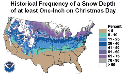
From a study of 275 first order NOAA Weather Service locations across the country, NCDC climatologists found the greatest snow depth on the ground on Christmas Day occurred in 1902 at Kalispell Glacier Airport in Montana: 125 inches (318 cm). The largest accumulation of snow, 29 inches (73.7 cm), fell on Christmas Day, 1929 at Valdez, Alaska.
 The analyses presented here are based on what happened in the past and are only odds for a white Christmas based on that data set. As Christmas Day approaches, the actual chance for a white Christmas depends on the actual weather situation just before and during Christmas Day. And the odds are also affected by other prevailing weather cycles, such as the presence of an El Niño or La Niña event. Will global warming decrease the odds? In some locations, most definitely, but perhaps it will increase the odds in other regions and only slightly reduce them in many. And for many who travel, the thoughts of a newly white landscape can be worrisome.
As I now live in a more northerly location and at higher elevation, I am actually hoping for a perfect Christmas.
NOAA map for probability of a white Christmas updated December 2010 with new climate normals. Unfortunately, I have been unable as yet to find updated versions of similar charts.
 |
To Purchase Notecard, |
Now Available! Order Today! | |
 |
 |
NEW! Now Available in the US! |
The BC Weather Book: |


 So what are the odds of a white Christmas? Of course, for any given year, the probability can be altered by the current weather pattern prevailing during late December, but the use of climatology allows a first guess. If over the last 100 years, there have been 20 Christmases deemed "white," then the probability is one in five or 20 percent. Now that figure may be optimistic since it is acknowledged that the first half of the 20th Century was colder than most of the later decades across the North American continent, and perhaps the most recent climate normals should be used to determine a probability. Thankfully, the good data-crunching climatologists at Environment Canada and the US National Climate Data Center have done the analysis for me. (Though they don't totally agree on the best database to use, so we have to take cross-border comparisons loosely.) They differ slightly on the definition of what constitutes a white Christmas.