| Home | Welcome | What's New | Site Map | Glossary | Weather Doctor Amazon Store | Book Store | Accolades | Email Us |
 | |||||||||||||||||||||||||||||||||||||||||||||||||||
Applying The Barometer To Weather WatchingYou have a barometer. How can you use it as a weather watching aid? Here are a few tips, not an exhaustive list because I know there are others that might be interesting that I have not included. Watching Weather
While waiting and watching the skies for other weather signs, you might think about the current sea-level pressure reading. If it is lower than about 1000-1004 mb, your current weather is likely influenced by a low-pressure system. (I'll use millibars (mb) here for pressure since many barometers are so scaled. For kPa, divide by 10; hPa are also used and are equivalent to mb. For other units, see Barometers for Weather Watching.) If it is higher than say 1020 mb, high pressure is the likely local weather influence. For pressures above or below these limits, the more extreme the influence of storminess or clear skies. In between it is hard to say from the local sea-level pressure reading whether high or low pressure dominates, you may be within a transition zone. 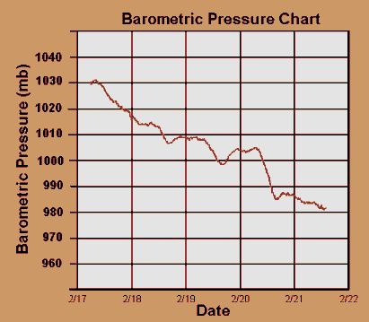 After an hour or more, take another reading. How has the pressure changed? Consider both how many millibars it changed and the direction of change. Has it risen, fallen, or remained unchanged? By how much has it changed? Barely, some, quite a lot? This change with time is what is referred to as the pressure tendency. If there has been no change, likely the weather you are seeing is not changing much unless there has been a significant change in temperature or solar radiation. Unfortunately, this is not a hard rule because a number of weather changes can occur with very small or no observable pressure changes — an isolated shower, for example. The following table gives terms used to describe pressure tendencies over a three-hour period. For the one-hour observation period, divide the table value by 3. You likely won't see the pressure reverse direction during the hour unless a front has passed over you.
The more rapid and extreme the pressure change over a few hours, the more extreme the weather change you can expect. This is particularly true with wind changes. If the pressure is changing by more than 1 mb/hour and if the tendency is downward, expect more stormy weather on the way. If an upward and quick change, storminess is moving out and clearing may be coming in the very near future although it may be quite windy. The speed of the wind depends on the local pressure gradients, which is the change in pressure over a distance. The greater the gradient, the stronger the wind. The pressure tendency is not always a good predictor of the absolute wind speed, but it can tell you how the wind is likely to change over the next few hours. For example, a strong wind can blow even when the local pressure remains fairly constant. This situation suggests a strong pressure gradient that may be unchanging with time or a pressure pattern that is not moving or doing so very slowly. In such cases, the wind speed may remain high for some time. A similar minimal pressure-change situation occurs when winds are light or changing very slowly, suggesting that they will continue to remain light. However, when winds are light (Beaufort Number 3 or less) and the pressure begins to change rapidly — 1 mb or more per hour — expect strong winds to develop shortly. The direction of the pressure change is not important for estimating wind speeds, only its magnitude. The direction does indicate if stormier weather is on its way (dropping pressure) or if clearing is in store (increasing pressure). As a general rule of thumb, the following table gives the likely Beaufort Scale wind speed expected for a given pressure tendency over land and over water. Such winds will likely also be gusty, so peak winds can be significantly higher.
When the pressure drop is moderate or rapid, the region will likely be coming under the influence of an approaching or deepening low pressure system, and therefore a greater likelihood for precipitation. Moderately or rapidly rising pressure usually presages fairer skies and drier weather ahead as a high pressure cell approaches or builds. Such is not always the case, because regional quirks may alter the picture. A prime example is in the snowbelt regions surrounding the Great Lakes when increasing pressure from an arctic high pressure system push strong, cold winds across the relatively warm lake waters to bury the lee shores in snow. If you are experiencing weather conditions that indicate a cold front is approaching, look for a change in the direction of the pressure tendency. Generally, pressure will fall prior to the front and rise rapidly as the cold front passes. Warm front passages are usually marked by pressure tendencies that stop falling and level out or begin to rise slowly after the front has passed. The more you watch how weather patterns develop in a specific region, the more you begin to see tell-tale signs in the weather patterns and their sequences. This improves your ability to forecast the coming weather and prepare you to see various weather phenomena. As Yogi Berra said, "You can see a lot by looking." As we extend our determination of pressure tendencies over three-, six- and twelve-hour periods, the more we can deduce about the weather to come. Many electronic barometers include an encoded forecast scheme that looks at the pressure history to produce a simple forecast for either fair weather, increasing cloudiness, precipitation likely, or clearing weather. In many situations and regions, this simple forecast scheme can be reasonably accurate over a six to twenty-four hour period. Here are some simple rules.
Finally, you likely have heard media meteorologists refer to an intense storm system as a bomb or a weather bomb. The strict definition for such a phenomenon is an extra-tropical low-pressure system whose central pressure falls at an average rate of 1 mb per hour for 24-hours, or 24 mb or more over a 24-hour period. Such rapid development can lead to some wild and dangerous weather. Sometimes at a given location, the passing of a deep storm system and its replacement with a strong high pressure cell can result in a pressure increase of 24 mb or more, and while not technically a bomb, the winds can be fierce during the period. Learn More From These Relevant Books
|
|||||||||||||||||||||||||||||||||||||||||||||||||||
 |
To Purchase Notecard, |
Now Available! Order Today! | |
 |
 |
NEW! Now Available in the US! |
The BC Weather Book: |


 In a previous