The devastation wrought by Hurricane Katrina in 2005 may have been the most deadly and damaging storm to strike the United States in a century (the deadly part depending on the final death toll which, at this writing, stands at 1,132). When all tallies are completed, the storm will be the costliest in US history and likely the third deadliest, at least since 1900.
Peaceful From Above Hurricane Katrina Dominates the Gulf 28 August 2005 Original Oil Painting by Keith C. Heidorn
New Orleans and the Louisiana coast are, however, no strangers to the forces of hurricane winds leaving death and destruction behind. On average, since 1871, a tropical storm/hurricane can be expected somewhere within the state every 1.2 years, and a hurricane makes landfall about every 2.8 years. From 1900 to 2004, Louisiana has taken 27 direct hits from hurricanes, the fourth most frequently hit state behind Florida, Texas and North Carolina. Great storms to ravage the Pelican State prior to 2005 include Georges (1998), Andrew (1992), Camille (1969), Betsy (1965), Audrey (1957), the August Hurricane of 1940, the September Hurricane of 1915, the Cheniere Caminanda Hurricane of 1893, the Isle Dernieres Hurricane of 1856, and the Racer's Storm of 1837. Estimates of the pre-Katrina total death toll from tropical storms in the state may be as high as 3000.
In fact, Katrina might not be the deadliest hurricane to hit the state. In 1893, the Cheniere Caminanda Hurricane of early October hit a region still reeling from a hurricane strike in early September. This storm, so named after the town Cheniere Caminanda where 779 died, struck suddenly on 1 October. Estimates of winds at 100 mph (160 km/h) and a measured pressure of 28.65 in Hg (970.2 hPa/mb) in the storm (though not necessarily the eye) would rank it as a Category 2 hurricane (Safir-Simpson Scale). The estimates of fatalities have been given as high as 2000, though most lists of deadly US natural disasters do not include it.
The first hint of severe tropical weather in the territory of Louisiana was recorded by a Spaniard named Panifo de Narvaez exploring the Florida coast. Bad luck seems to have dogged de Narvaez. Forced to abandon his Florida mission due to hunger and unfriendly natives, he took his five boat flotilla and 250 men (David Ludlum in his book Early American Hurricanes 1492-1870 cites 400) westward along the northern Gulf coast. On 23 October 1527 (Ludlum gives the date as 2 October 1528), while they passed the mouth of the Mississippi, a severe tropical storm caught the flotilla and tossed them like driftwood in the severe weather. Only ten of the shipwrecked party survived.
An Early Hit on New Orleans
The French settled New Orleans in 1718 as La Nouvelle-Orl�ans, named in honour of Philip II, Duke of Orl�ans, the regent and ruler of France at the time. French fur trappers and traders had camped along the bayou for at least a decade before the official founding of the settlement. The original site occupied a rare piece of natural high ground along the flood-prone lower Mississippi. It sat adjacent to a Native American trading route and portage between the Mississippi and Lake Pontchartrain. In early 1722 Nouvelle-Orl�ans became the capital of French Louisiana, replacing Biloxi.
New Orleans itself has faced the tropical storm threat from its earliest days, and hurricanes have played a major role in the city's history and lore. A great hurricanes struck the city in September 1722, almost completely destroying the city's fragile existing infrastructure. This hurricane is the first tropical storm to strike the region for which there are adequate first-hand accounts.
The Great Hurricane of 1722
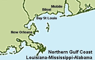
The storm's history, as reconstructed from past accounts, suggests it may have moved through the Lesser Antilles on 11 September (note that the dates used here are based on our current calendar, the actual dates on the calendar in use at the time were 11 days earlier), then made landfall somewhere west of the mouth of the Mississippi on the 23rd. This position placed the Gulf Coast from Mobile to the river mouth in the dangerous right frontal sector of the storm. In addition, this section of the Gulf Coast is particularly susceptible to storm surge damage because it makes a "corner" in the coastline. That is, the angle made by the Mississippi Delta with the rest of the Gulf coast is nearly ninety degrees which can amplify surge waters pushed shoreward by an east wind.
Information on the storm has been presented by David Ludlum in his book Early American Hurricanes 1492-1870 and is drawn from contemporary accounts in a letter from De L'Orme to French officials at home and in the journal of Diron D'Artaguiette. This essay is based on those reports.
The storm struck with a vengeance the evening of 23 September when hurricane-force southeast winds and a high surge struck New Orleans. In 1718, approximately three-foot (one metre) high levees (today they are 17 feet (5.2 m) high) protected New Orleans from both river and tidal overflow, but this proved an inadequate defense as the storm surges were reported to be about 3 ft (1 m) at Bayou St John, 7-8 ft (2.1-2.4 m) at Bay St Louis and 8 ft (2.4 m) in the Mississippi River.
On 23 September, D'Artaguiette wrote: "Toward ten o'clock in the evening there sprang up the most terrible hurricane which has been seen in these quarters." He further remarked: "The ships, the Santo Christe and the Neptune, and two passenger-boats, one of which was used as a powder magazine were damaged and grounded far ashore....It was remarkable that if the Mississippi had been high this hurricane would have put both banks of the river more than 15 feet [(4.6 m)] under water, the Mississippi, although low, having risen 8 feet [(2.4 m)]."
Hurricane force winds lasted 15 hours. Wind observations from two German settlements 30 miles (50 km) north of New Orleans indicate from the wind shifts there that the storm's eye moved inland west of the Mississippi and headed north across the central region of Louisiana. Rainfall and flooding were reported to have lasted for five days.
D'Artaguiette reported the next day:
"The hurricane, continuing until mid-day, has not ceased to rage, but at noon, it having become much calmer, we learned from some people who had just come from the settlement of Srs Trudeau and Coustillas, that the houses there were blown down and the crops lost."
The buildings in New Orleans suffered extensive destruction, though they were not of high grade construction having been hastily constructed when New Orleans was initially selected to be the capital of the Louisiana Company in 1717-18. Thirty six huts were destroyed during the storm, which included the area hospital and the St Louis church.
The impact on the port and the various vessels docked there was major. Ten flat-boats were broken apart and sunk by wind and water as were launches, canoes and pirogues. "In fact," D'Artaguiette noted with finality, "everything in port was lost." Similar destruction was reported from upriver. Three pirogues owed by a man named Poussin, were lost 15 miles (24 km) above New Orleans. He had been caught by the storm coming downriver to sell his lot of fowl, Indian corn and other goods.
Plantation crops along the river shoreline above and below New Orleans were laid low by combination of wind and rain. The flooding also prevented the harvesting of the rice crop. D'Artaguiette lamented: "The loss to the colony, however, will be very considerable, because there was a great deal of rice ready to cut but which is entirely lost."
The bayou between New Orleans and Biloxi was filled with two to three feet (0.6-0.9 m) of water as a result of the storm. Fort St Louis, on the bay, lost all its houses and storehouses when the surge rose "7 or 8 feet [2.1-2.4 m] more than is ordinary and, that it has partially inundated the place" (D'Artaguiette). This storm was also responsible for moving Mobile from its old site 27 miles (43 km) north of the mouth of the Mobile River to its present-day site.
Interestingly, the storm's destruction in New Orleans raised much political bickering, particularly from the older settlements who felt slighted by its choice as the site for the Louisiana Company capital. Their rancour was furthered when a major flood inundated the city three years later.
Leaving the coast, the storm then passed through Central Louisiana. This same storm most likely re-curved northeast and headed into South Carolina, according to Ludlum, as they reported three days of flooding rains around the 27th: the most violent rain "without intermission that the English inhabitants ever knew." (John Bartram, 1766)
Written by Keith C. Heidorn, PhD, THE WEATHER DOCTOR,
October 1, 2005
Learn More About Hurricanes From These Relevant Books Chosen by The Weather Doctor
For More Weather Doctor articles, go to our Site Map.
I have recently added many of my lifetime collection of photographs and art works to an on-line shop where you can purchase notecards, posters, and greeting cards, etc. of my best images.